|
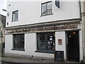
Golden ghost again - Stroud, Gloucestershire
by Martin Richard Phelan
geograph for square SO8505
A slightly different view of the Golden Fleece Inn, 9 Nelson Street in Stroud.... (more)
|
|
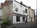
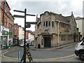
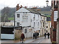
Golden ghost - Stroud, Gloucestershire
by Martin Richard Phelan
for square SO8505
The Golden Fleece Inn, 9 Nelson Street in Stroud. The list of landlords in this... (more)
|
|
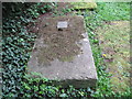
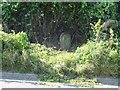
Not the last duellist - Stroud, Gloucestershire
by Martin Richard Phelan
for square SO8505
In a corner of the churchyard to the south-west of St Laurence's Parish... (more)
|
|
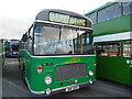
Preserved Bristol RE bus at Stagecoach Bus Depot, Swindon (2))
by David Hillas
for square SU1385
This photo shows Bristol RESL6G with Eastern Coach Works 43-seater bodywork... (more)
|
|
Once the Greyhound - Stroud, Gloucestershire
by Martin Richard Phelan
geograph for square SO8505
The Greyhound Inn, at the junction of Gloucester Street and Lansdown in Stroud,... (more)
|
|
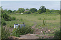
On Toadsmoor Pond - Eastcombe, Gloucestershire
by Martin Richard Phelan
geograph for square SO8804
Toadsmoor Pond is a stretch of water in the Toadsmoor Valley away to the... (more)
|
|
Wonder of Woolies - Stroud, Gloucestershire
by Martin Richard Phelan
geograph for square SO8505
Taken from the junction of King Street and George Street, this is the former... (more)
|
|
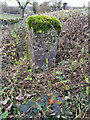
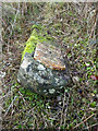
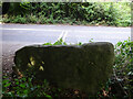
Milestone, A419 (old road)
by James Clarke
for square SO9001
By the entrance to Westley Farm, on the verge of the original route of the road.... (more)
|
|
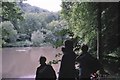
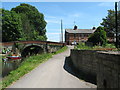
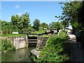
Towpath at Ryeford - Stonehouse, Gloucestershire
by Martin Richard Phelan
geograph for square SO8104
A view from the towpath of the Stroudwater Canal, looking eastwards to Ryeford... (more)
|
|
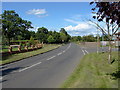
Stroude Road
by Alan Hunt
geograph for square TQ0169
A view along Stroude Road on its way towards Egham. The junction with Hurst lane... (more)
|
|
Stroude Road
by Alan Hunt
geograph for square TQ0069
A view along Stroude Road heading in the direction of Egham.
|
|
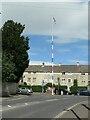
Paganhill maypole, Stroud, from the north-east
by Christine Johnstone
geograph for square SO8305
Currently being used as a flagpole. A plaque near the base reads 'This... (more)
|
|
Paganhill maypole, Stroud, from the south-east
by Christine Johnstone
geograph for square SO8305
Currently being used as a flagpole. A plaque near the base reads 'This... (more)
|
|
Milestone, Cirencester, A419
by Mr Red
for square SO9901
On the Southern verge almost buried in the soil. Near a field gate. The top of... (more)
|
|
Milestone, A419
by Mr Red
for square SO9701
On the southern verge. The milestone must have been canted backwards at an angle... (more)
|
|
Milestone, A419
by Mr Red
for square SO9301
Fallen over, a little East of Beacon Farm. Benchmark represents 187.9 m ASL... (more)
|
|
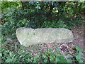
Milestone, Frocester Hill
by Mr Red
geograph for square SO7902
The Bench Mark on top put the ASL at variously 62.7m in 1965 or 203.3ft in... (more)
|
|
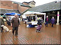
Farmers' market, Cornhill Market Place, Stroud
by Chris Allen
geograph for square SO8505
A large and popular market held in Stroud on Saturdays
|
|
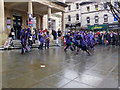
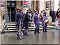
Morris Dancers, Stroud
by Chris Allen
for square SO8505
I didn't expect to see hordes of morris dancers in Stroud on a Saturday... (more)
|
|
Morris dancers, Stroud
by Chris Allen
for square SO8505
In front of Stroud Subscription Room, now home to Tourist Information.
|
|
Morris dancers, Stroud
by Chris Allen
for square SO8505
These were the musicians for a group of blacked-up morris men in front of Stroud... (more)
|
|
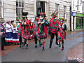
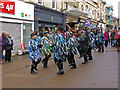
Morris Men - King Street, Stroud
by Chris Allen
for square SO8505
Stroud was full of troups of morris dancers performing in several locations... (more)
|
|
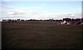
Across the Common - Box, Gloucestershire
by Martin Richard Phelan
geograph for square SO8500
A view across the wide expanse of Minchinhampton Common and like Rodborough... (more)
|
|
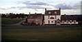
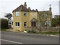
Halfway House as was - Box, Gloucestershire
by Martin Richard Phelan
geograph for square SO8500
This is the Halfway House pub (public house) at Box (OS Explorer 168). It stands... (more)
|
|
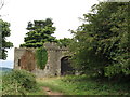
Rodborough Fort corner - Stroud, Gloucestershire
by Martin Richard Phelan
geograph for square SO8404
Standing on Rodborough Common, high above Stroud and its meeting of five... (more)
|
|
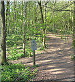
Trees in the afternoon - Randwick, Gloucestershire
by Martin Richard Phelan
geograph for square SO8307
A visit to the sunlit paths of the National Trust-owned Standish Wood, on the... (more)
|
|
Road now where the rails were - Stroud, Gloucestershire
by Martin Richard Phelan
geograph for square SO8304
Tarmac and wheeled vehicles have now replaced the rails and trains which ran... (more)
|
|
Approach to the Dudbridge Station site - Stroud, Gloucestershire
by Martin Richard Phelan
geograph for square SO8304
Photo taken on the approach to Dudbridge Station roundabout and the site of the... (more)
|
|
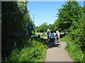
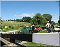
Side by side - Ryeford, Gloucestershire
by Martin Richard Phelan
geograph for square SO8104
Only a few years ago, this sight would have been unthinkable. This Geographer... (more)
|
|
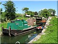
Open again - Ryeford, Gloucestershire
by Martin Richard Phelan
geograph for square SO8104
After many years of dereliction the Stroudwater Canal, enjoyed only by walkers,... (more)
|
|
From dereliction to renovation - Ryeford, Gloucestershire
by Martin Richard Phelan
geograph for square SO8104
Work on the Stroudwater Canal began in 1776 to provide a link with the River... (more)
|
|
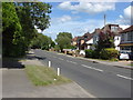
Whitehall Lane, Stroude
by Alan Hunt
geograph for square TQ0069
Looking east along Whitehall Lane from near Whitehall Farm.
|
|
Field off Whitehall Lane
by Alan Hunt
geograph for square TQ0069
The field to the north of Whitehall Lane near Stroude.
|
|
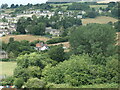
Humphries End
by Christine Johnstone
geograph for square SO8306
Looking westwards across the northern edge of Stroud.
|
|
South side, Central Road, Downfield, Stroud
by Christine Johnstone
geograph for square SO8405
Social housing built between 1921 and 1935 on the site of some allotments.
|
|
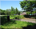
Stone Stile, Lightpill
by Mr Red
for square SO8303
Off the A46 Bath Rd, in the Lightpill area of Rodborough, Stroud. Not on a... (more)
|
|
Stone Stile, Lightpill
by Mr Red
for square SO8303
Off the A46 Bath Rd, in the Lightpill area of Rodborough, Stroud. Not on a... (more)
|
|
Stancombe Toll House, Bisley
by Mr Red
geograph for square SO8906
Currently named "The Old Toll House" by the owners. On Bisley Road,... (more)
|
|
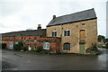
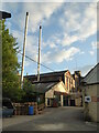
Buildings by Lodgemore Mills, Stroud
by Chris Allen
geograph for square SO8405
An older range of buildings next to Lodgemore Mills. The building on the right... (more)
|
|
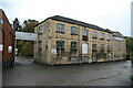
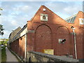
Lodgemore Mills, Rodborough
by Chris Allen
geograph for square SO8405
This is one of the very few working textile mills in the south-west and... (more)
|
|
Lodgemore Mill, Stroud
by Chris Allen
geograph for square SO8405
This is one of the very few working textile mills in the south-west and... (more)
|
|
Lodgemore Mill, Stroud
by Chris Allen
geograph for square SO8405
This is one of the very few working textile mills in the south-west and... (more)
|
|
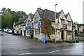
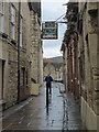
The Clothiers Arms, Stroud
by Chris Allen
geograph for square SO8404
A public house on the A46 Bath Road and overlooking Lodgemore Mill.
|
|
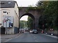
Merrywalks in Stroud
by Steve Daniels
geograph for square SO8405
|
|
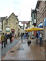
Union Street, Stroud
by Chris Allen
geograph for square SO8505
People going about their business.
|
|
Another closed public house
by Chris Allen
geograph for square SO8505
The Market Tavern, Stroud
|
|
Retreat - is that an instruction?
by Chris Allen
geograph for square SO8505
No, it's a public house in Stroud. The pavement was wet due to recent rain.
|
|
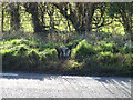
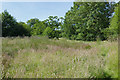
Scrub near Stroude
by Alan Hunt
geograph for square TQ0069
An area of scrubland near the railway line on the footpath from Whitehall Farm... (more)
|
|
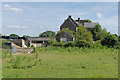
Whitehall Farm, Stroude
by Alan Hunt
geograph for square TQ0069
The derelict farmstead viewed from the northwest.
|
|
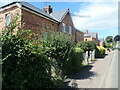
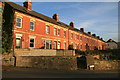
Stroud - terrace houses off Field Road
by Chris Allen
geograph for square SO8504
|