|
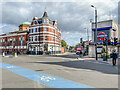
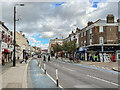
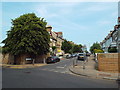
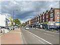
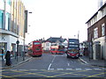
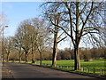
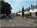
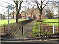
Tooting Bec Road
by Ian Capper
geograph for square TQ2872
Looking along Tooting Bec Road from its junction with Upper Tooting Road/Balham... (more)
|

|
Tooting Bec Common
by Lauren
geograph for square TQ2972
|
|
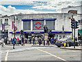
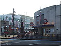
Tooting Broadway Underground Station
by Ian Capper
geograph for square TQ2771
Station on the 1926 Morden extension of the City and South London Railway (later... (more)
|
|
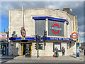
Tooting Bec Underground Station
by Ian Capper
geograph for square TQ2872
Station on the 1926 Morden extension of the City and South London Railway (later... (more)
|
|
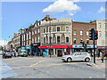
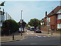
Tooting High Street/Mitcham Road
by Ian Capper
geograph for square TQ2771
Buildings at the junction of Tooting High Street (on the left) and Mitcham Road... (more)
|
|
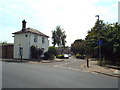
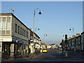
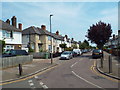
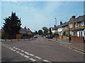
Upper Tooting Road
by Ian Capper
geograph for square TQ2772
Looking along Upper Tooting Road from near its junction with Lynwood Road.
|
|
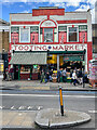
Tooting Market
by Ian Capper
geograph for square TQ2771
Market hall on Tooting High Street, dating from 1930.
|
|
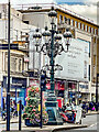
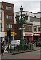
Gaslamp standard
by Ian Capper
geograph for square TQ2771
Late 19th Century gaslamp standard/signpost at the junction of Tooting High... (more)
|
|
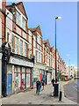
Tooting High Street
by Ian Capper
geograph for square TQ2770
Early 20th Century parade of shops/flats in Tooting High Street.
|
|
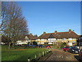
Brodrick Road, Upper Tooting
by Malc McDonald
geograph for square TQ2772
Brodrick Road is a residential street in Upper Tooting, in the suburbs of south London.
|
|
College Gardens, Upper Tooting
by Malc McDonald
geograph for square TQ2772
College gardens is a residential street in Upper Tooting, in the suburbs of sotuh London.
|
|
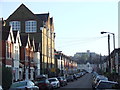
Undine Street, Tooting
by Malc McDonald
geograph for square TQ2771
Undine Street is a residential street close to Tooting Broadway. The taller... (more)
|
|
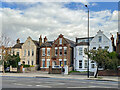
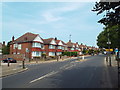
227 - 231 Balham High Road
by Ian Capper
geograph for square TQ2872
Late 19th Century houses in Balham High Road, first marked on the 1895 1:1056 plan.
|
|
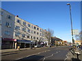
Balham High Road
by Ian Capper
geograph for square TQ2872
Late 19th Century parades of shops/flats in Balham High Road, first marked on... (more)
|
|
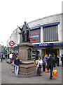
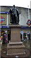
King Edward VII statue, Tooting
by Stephen Craven
for square TQ2771
The statue has pride of place outside Tooting Broadway tube station. Sculptor L... (more)
|
|
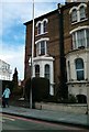
172 Trinity Road, Tooting
by PAUL FARMER
geograph for square TQ2773
The Blue Plaque on the house indicates that Thomas Hardy (1840-1928), poet &... (more)
|
|
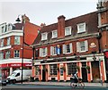
The Castle, Public House, Tooting High Street
by PAUL FARMER
geograph for square TQ2771
|
|
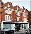
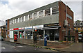
NatWest Bank Tooting High Street
by PAUL FARMER
geograph for square TQ2771
|
|
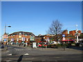
Mitcham Road, Tooting Broadway
by PAUL FARMER
geograph for square TQ2771
|
|
Statue of Edward VII at Tooting Broadway
by PAUL FARMER
geograph for square TQ2771
This statue has Edward VII dressed as... (more)
|
|
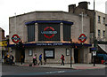
Tooting Bec Underground Station
by Jim Osley
geograph for square TQ2872
Once known as Trinity Road.
|
|
Longmead Road, Tooting Broadway
by Malc McDonald
geograph for square TQ2771
Longmead Road is used as a terminus for bus routes terminating at Tooting Broadway.
|
|
Tooting Broadway station
by Malc McDonald
geograph for square TQ2771
Tooting Broadway station in South London is on London Underground's... (more)
|
|
Garratt Lane, Tooting
by Malc McDonald
geograph for square TQ2771
Garratt Lane, viewed at the Tooting Broadway junction.
|
|
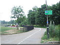
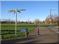
Shared path, Tooting Bec Common
by Malc McDonald
geograph for square TQ2972
This path across Tooting Bec Common is shared by pedestrians and cyclists.
|
|
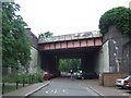
Railway bridge, Tooting Bec Common
by Malc McDonald
geograph for square TQ2973
This railway bridge crosses a path at the entrance to Tooting Bec Common in... (more)
|
|
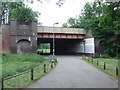
Railway bridge, Tooting Bec Common
by Malc McDonald
geograph for square TQ2972
This bridge carries the railway over a path on Tooting Bec Common in South London.
|
|
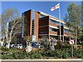
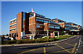
St George's Hospital, Tooting
by Jonathan Hutchins
geograph for square TQ2671
|
|
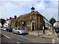
Former St Swithun's Church on the corner of Kellino Street and St Cyprian's Streets
by PAUL FARMER
geograph for square TQ2771
|
|
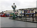
Lamp standard and direction signs, Tooting Broadway
by Jim Osley
geograph for square TQ2771
|
|
Tooting Post Office
by Jim Osley
geograph for square TQ2771
|
|
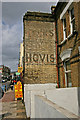
'Ghost sign', Upper Tooting
by Jim Osley
for square TQ2772
|
|
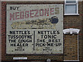
'Ghost sign', Upper Tooting
by Jim Osley
for square TQ2772
|
|
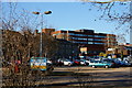
St.George's Hospital, Tooting
by Peter Trimming
geograph for square TQ2671
Looking towards the Atkinson Morley Wing. Note the flag.
|
|
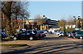
St.George's Hospital, Tooting
by Peter Trimming
geograph for square TQ2771
Looking across the public car park, from Blackshaw Road.
|
|
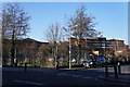
St.George's Hospital, Tooting
by Peter Trimming
geograph for square TQ2771
View across the public car park, from Blackshaw Road.
|
|
St.George's Hospital, Tooting
by Peter Trimming
geograph for square TQ2771
View from Blackshaw Road.
|
|
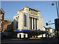
Former cinema, Tooting
by Malc McDonald
geograph for square TQ2771
This bingo hall was built as a cinema which opened in 1931. It is now Grade I listed.
|
|
Manship Road, Mitcham
by Malc McDonald
geograph for square TQ2869
Manship Road is a residential road in Mitcham, in the suburbs of south London.... (more)
|
|
Figge's Marsh, Mitcham
by Malc McDonald
geograph for square TQ2869
A pavement leading to a path across Figge's Marsh in Mitcham, in the... (more)
|
|
Trees in winter, Mitcham
by Malc McDonald
geograph for square TQ2768
Trees in Mitcham on a day in early January. The trees were bare, and were... (more)
|
|
Madeira Road, Mitcham
by Malc McDonald
geograph for square TQ2768
Madeira Road forms part of the route of the A239 road in Mitcham, in the suburbs... (more)
|
|
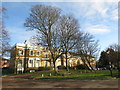
Mitcham town centre
by Malc McDonald
geograph for square TQ2768
A view of Mitcham town centre, taken on a day in early January. Trees were bare... (more)
|
|
London Road, Mitcham
by Malc McDonald
geograph for square TQ2769
London Road in Mitcham forms part of the route of the A217 road.
This image... (more)
|
|
Lidiard Road, near Earlsfield
by Malc McDonald
geograph for square TQ2672
Lidiard Road is a narrow residential street in the suburbs of south London.
|
|
Aldrich Terrace, near Earlsfield
by Malc McDonald
geograph for square TQ2672
Aldrich Terrace is a short residential street in the suburbs of south London.
|
|
Headington Road, near Earlsfield
by Malc McDonald
geograph for square TQ2672
Headington Road is a residential street in the suburbs of south London.
|
|
Fieldview, near Earlsfield
by Malc McDonald
geograph for square TQ2672
Fieldview is a narrow residential street in the suburbs of South London.
The... (more)
|
|
Burntwood Lane, near Earlsfield
by Malc McDonald
geograph for square TQ2672
Burntwood Lane is a residential "B" road in the suburbs of south London.
|
|
Footpath across Cricket Green, Mitcham
by Malc McDonald
geograph for square TQ2768
A public footpath across Cricket Green in Mitcham, in the suburbs of south... (more)
|