Public Tags
Tag: Torness
Other tags: power station:Torness
Showing latest 50 of 1,179 images tagged with Torness tag.
|
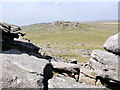
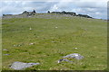
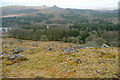
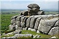
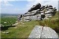
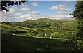
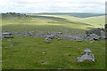
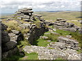
Roos Tor from Great Staple Tor
by Tony Atkin geograph for square SX5476 Roos Tor is the third and last in a line of tors which make a great walk from... (more)
|
|
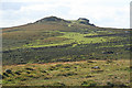
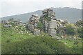
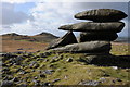
Mary Tavy: Hare Tor
by Martin Bodman for square SX5584 Hare Tor stands on the right with Sharp Tor immediately to its left. Then... (more)
|
|
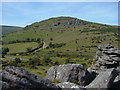
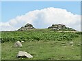
Hookney Tor
by Derek Harper geograph for square SX6981 "Of the tors that reside between the watersheds of the West and East... (more)
|
|
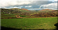
Dart valley around Luckey Tor
by Derek Harper for square SX6872 From Wheal Emma Leat, with Rowbrook the farm across the valley in the centre.... (more)
|
|
Towards White Tors
by Graham Horn geograph for square SX6280 From a point somewhere on the wide col south of Broad Down. The view is roughly... (more)
|
|
Dartmoor: Bench Tor (2)
by Nigel Cox geograph for square SX6971 In the centre mid-distance is the northernmost of one of several scattered... (more)
|
|
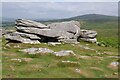
Boulder near Chinkwell Tor
by Derek Harper for square SX7378 Southeast of Chinkwell Tor, with Bell Tor below on the right. Saddle Tor and... (more)
|
|
|
Snow Panorama of four well-known Dartmoor Tors
by Sloop John B for square SX7576 120 degree sweep. Tors, from the pimple on the far left: Hound Tor (20⁰,... (more)
|
|
Sharp Tor, near Dartmeet, Devon
by Edmund Shaw geograph for square SX6873 There are four tors called Sharp Tor, this is the one between Dartmeet and... (more)
|
|
Great Staple Tor from Middle Staple Tor
by Graham Horn geograph for square SX5475 As you round the impressive rocks of Middle Staple Tor, the even more impressive... (more)
|
|
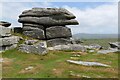
Pil Tor
by Derek Harper geograph for square SX7375 Category: Tors A family enjoys the last minutes of sunshine on a wintry afternoon. Pil Tor is a... (more)
Tags:
Access LandX
Avenue TorX
national park:DartmoorX
top:MoorlandX
top:Rocks, Scree, CliffsX
top:Sport, LeisureX
TorX
top:UplandsX
WalkersX
|
|
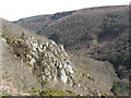
Dart valley below Sharp Tor
by Derek Harper for square SX6872 A view from the Holne Moor Leat. The wood on the right is White Wood; ahead on... (more)
|
|
View from Sheep's Tor
by Graham Horn geograph for square SX5668 It was a reasonably clear day, better than yesterday. The view from the large... (more)
|
|
Ascending Sheep's Tor
by Graham Horn geograph for square SX5668 The ascent of Sheep's Tor from the north is steep. Any excuse therefore... (more)
|
|
Showery Tor
by Tony Atkin geograph for square SX1481 A view of Showery Tor seen from the saddle between Showery Tor and Rough Tor.
|
|
Ilsington: towards Saddle Tor
by Martin Bodman geograph for square SX7576 The B3387 runs beneath the tor. Seen from path to Bag Tor
|
|
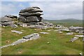
Bell Tor
by Alan Hunt geograph for square SX7377 Bell Tor from Bonehill Rocks with Chinkwell Tor on the summit behind Bell Tor.
|
|
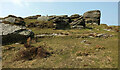
Pew Tor
by Philip Halling geograph for square SX5373 Rock outcrops on Pew Tor on Dartmoor.
|
|
Rocks on Pew Tor
by Philip Halling geograph for square SX5373 Rocks on Pew Tor on Dartmoor.
|
|
Pew Tor
by Philip Halling geograph for square SX5373 Rock outcrops on Pew Tor on Dartmoor.
|
|
Pew Tor
by Philip Halling geograph for square SX5373 Rock outcrops on Pew Tor on Dartmoor.
|
|
Pew Tor
by Philip Halling geograph for square SX5373 Rocks on Pew Tor on Dartmoor.
|
|
Vixen Tor
by Philip Halling for square SX5474 One of the many rocky tor outcrops on Dartmoor. Great Mis Tor can be seen in... (more)
|
|
Top Tor
by Colin Smith geograph for square SX7376 Top Tor has jointed and weathered granite outcrops at the top of Blackslade... (more)
|
|
Towards Widecombe
by Derek Harper geograph for square SX7174 From a lane near Stone Cross, with the lane between Stone Cross and Cockingford... (more)
|
|
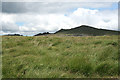
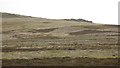
Over Broad Moss towards Langlee Crags
by Richard Webb geograph for square NT9621 The southern tors seen over an area of peat.
Tags:
BogX
type:GeographX
top:Geological InterestX
top:Lakes, Wetland, BogX
top:MoorlandX
top:Rocks, Scree, CliffsX
TorsX
|
|
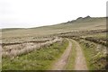
Langlee Crags
by Richard Webb geograph for square NT9622 Some of the tors east of Hedgehope Hill.
|
|
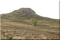
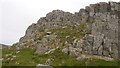
Housey Crags
by Richard Webb for square NT9521 One of the tors east of Hedgehope Hill. It provides a few short rock routes.... (more)
|
|
Rocks west of Doe Tor
by Derek Harper for square SX5384 In truth, Doe Tor sprawls over a fair distance from east to west, with several... (more)
|

|
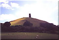
Glastonbury Tor
by Rossographer geograph for square ST5138 The summit of Glastonbury Tor Link
|
|
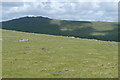
View above Widecombe
by Derek Harper geograph for square SX7176 A summer version of the scene in SX7176 : Field above Widecombe, again with West Hayes the nearest... (more)
|
|
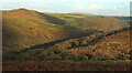
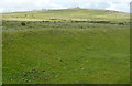
View towards Great Trowlesworthy Tor
by Graham Horn geograph for square SX5864 Taken from near the settlements on Lee Moor. There is a shallow, but wet,... (more)
|
|
Across to Honeybag Tor
by Graham Horn geograph for square SX7179 On the far side of the East Webburn valley are (l-r) Honeybag Tor and Chinkwell... (more)
|
|
Peter Tavy: below Cox Tor
by Martin Bodman geograph for square SX5275 On the bracken-covered western slopes of Cox Tor. With Brent Tor just a pimple... (more)
|
|
Roos Tor from Great Staple Tor
by Graham Horn geograph for square SX5476 An easy walk, but not on our agenda today. The empty interior of Dartmoor looks... (more)
|
|
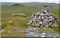
Summit of Higher White Tor
by Graham Horn geograph for square SX6178 It is quite unusual in this area to have a cairn. The summit is usually rocky... (more)
|
|
Green Tor
by Graham Horn geograph for square SX5686 The rocks at the south end of the tor. This is quite a prominent tor from the... (more)
|
|
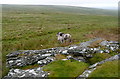
Ponies at Green Tor
by Graham Horn geograph for square SX5686 As we approached the top of Green Tor we disturbed this pony and foal that were... (more)
|
|
Tor on Hayne Down
by Derek Harper geograph for square SX7480 Part of the impressive tor on the western summit of the hill. But the tor is... (more)
|
|
A View of Middle Staple Tor
by Tony Atkin geograph for square SX5475 Looking southwest from Great Staple Tor to the rocky pile of Middle Staple Tor... (more)
|
|
Little Staple Tor
by Tony Atkin geograph for square SX5375 Little Staple Tor is a rocky outcrop on the shoulder of the southern slope of... (more)
|
|
Approaching Longaford Tor
by Tony Atkin geograph for square SX6177 Longaford Tor is the 'rockpile' in the foreground. It's bigger... (more)
|
|
On Great Mis Tor
by Tony Atkin geograph for square SX5676 Great Mis Tor is large as Dartmoor tors go, the summit has its own mini landscape.
|
|
Showery Tor
by Philip Halling geograph for square SX1481 The eyecatching rock outcrop of Showery Tor with Rough Tor in the background.
|
|
Daddy bear, mummy bear and baby bear
by Graham Horn geograph for square SX5375 Also known as Great Staple Tor, Middle Staple Tor and Little Staple Tor. Seen... (more)
|
|
View from Middle Staple Tor
by Graham Horn geograph for square SX5475 Away from the summit rocks this tor consists of gentle moorland and a few... (more)
|
|
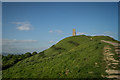
Glastonbury Tor at Midday
by nick macneill geograph for square ST5138 Category: Tors |
|
Sharp Tor
by Stephen Craven geograph for square SX7289 Category: Tors This tor consists of two rock outcrops on the northern slope of the Teign... (more)
|
|
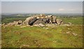
Housey Crags
by Richard Webb geograph for square NT9521 Broken crags, but there is a clean steep face which provides a few routes.
|
|
Glastonbury Tor
by Brian Deegan geograph for square ST5138 Glastonbury Tor is a hill near Glastonbury in the English county of Somerset,... (more)
|