Public Tags
Tag: Vale·of·Aylesbury
Showing images tagged with Vale of Aylesbury tag.
|
Vale of Aylesbury
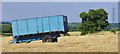
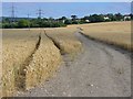
by Colin Smith geograph for square SP8507 Cereal cropping west of Wendover in the fertile Vale of Aylesbury.
Tags:
top:Farm, Fishery, Market GardeningX
type:GeographX
top:LowlandsX
subject:TrailerX
Vale of Aylesbury
|
|
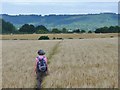
Butler's Cross - Barley Field
by Colin Smith geograph for square SP8407 Cereal crop in the Vale of Aylesbury. The Aylesbury Ring Path crosses this... (more)
Tags:
BarleyX
place:Butlers CrossX
subject:CropX
top:Farm, Fishery, Market GardeningX
type:GeographX
top:LowlandsX
Vale of Aylesbury
|
|
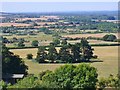
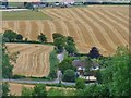
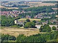
Northfield Grange
by Colin Smith for square SP9413 View from The Ridgeway on top of the Chiltern Hills, looking west over the... (more)
|
|
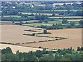
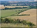
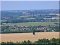
Vale of Aylesbury
by Colin Smith for square SP8408 Flat landscape of fields, hedgerows and woods to the north of Coombe Hill, west... (more)
|
|
Wendover - Wheat Field
by Colin Smith geograph for square SP8608 Cereal crop in the southern fringe of the Vale of Aylesbury.
|
|
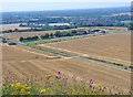
Vale of Aylesbury
by Colin Smith geograph for square SP8507 View from Bacombe Hill in the Chilterns, northwards to harvested cereal fields... (more)
|
|
Ivinghoe - Town Farm
by Colin Smith geograph for square SP9516 Large rectangular fields line the B489 at the foot of Ivinghoe beacon.
Tags:
top:Farm, Fishery, Market GardeningX
subject:FieldX
type:GeographX
place:IvinghoeX
Vale of Aylesbury
|
|
Middle Path Farm
by Colin Smith geograph for square SP9515 Patchwork of cereal and grassy fields at the foot of Steps Hill.
Tags:
top:Farm, Fishery, Market GardeningX
type:GeographX
subject:LandscapeX
top:LowlandsX
Vale of Aylesbury
|
|
Pitstone
by Colin Smith for square SP9414 Church End, part of Pitstone village at the foot of the Chiltern scarp - viewed... (more)
Tags:
type:Cross GridX
place:PitstoneX
Vale of Aylesbury
subject:VillageX
top:Village, Rural SettlementX
|

|
Ivinghoe from the Beacon
by Colin Smith geograph for square SP9516 View SW from the top of Ivinghoe Beacon (230m amsl). Flowers bloom on the chalk... (more)
Tags:
Chalk GrasslandX
top:Farm, Fishery, Market GardeningX
type:GeographX
top:GrasslandX
place:IvinghoeX
subject:LandscapeX
top:LowlandsX
Vale of Aylesbury
|
|
Pitstone Windmill
by Colin Smith for square SP9415 Pitstone Windmill, Grade II listed, is thought to have been built early 17th... (more)
|