Public Tags
Tag: View·of·Ben·Wyvis
Showing images tagged with View of Ben Wyvis tag.
|
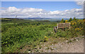
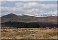
Bench with a view, Boblainy Forest
by Craig Wallace geograph for square NH4937 A view north towards Ben Wyvis. The cleared area in the foreground is now... (more)
Tags:
BenchX
place:Boblainy ForestX
Cleared ForestX
type:GeographX
ViewX
View of Ben Wyvis
top:Woodland, ForestX
|
|
Bench with a view, Boblainy Forest
by Craig Wallace geograph for square NH4937 A bench next to the forest track. Looking across the valley of the Bruiach Burn.... (more)
|
|
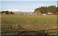
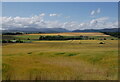
Fields by Newton
by Craig Wallace geograph for square NH5753 Grassy fields near the top of the Black Isle. Looking towards some old buildings... (more)
|
|
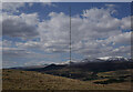
Anemometer mast, Cnoc a' Bhreacaich
by Craig Wallace geograph for square NH5462 The mast is close to the summit of Cnoc a' Bhreacaich. Presumably measuring... (more)
|
|
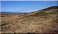
Moorland, by Leidchruich
by Craig Wallace geograph for square NH5262 A view towards Cìoch Mhòr and Ben Wyvis.
|
|
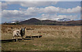
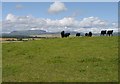
Sheep, by Leidchruich
by Craig Wallace geograph for square NH5261 A Jacob sheep on the rough grazing. A view towards Cìoch Mhòr, and Ben Wyvis beyond.
Tags:
top:Farm, Fishery, Market GardeningX
type:GeographX
top:GrasslandX
top:MoorlandX
Rough GrazingX
SheepX
ViewX
View of Ben Wyvis
|
|
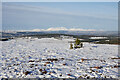
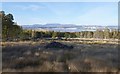
Carn na Leitire view
by Craig Wallace geograph for square NH5434 A view from the summit. Looking across snow covered moorland towards Ben Wyvis.
Tags:
Abriachan ForestX
Carn Na LeitireX
type:GeographX
top:MoorlandX
SnowX
top:UplandsX
View of Ben Wyvis
|
|
Bare field, by Parkton
by Craig Wallace geograph for square NH5950 A view from the edge of Gallowhill Wood. Looking across a bare field, then... (more)
Tags:
top:Farm, Fishery, Market GardeningX
plant:GorseX
top:LowlandsX
Ploughed FieldX
ViewX
View of Ben Wyvis
top:Woodland, ForestX
|
|
Fields by Balavil
by Craig Wallace geograph for square NH5453 Grassy fields next to Balavil Farm, with a herd of cattle grazing.
Good views... (more)
|
|
Cleared forest, by Lentranhill
by Craig Wallace geograph for square NH5844 It looks like this area of forest has been cleared a while ago. There is several... (more)
|
|
Cleared forest, by Reelig
by Craig Wallace geograph for square NH5642 It looks like this area of forest has been cleared a few years ago, there's... (more)
|
|
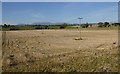
Power line, Auchmore Wood
by Craig Wallace geograph for square NH4950 Part of the Beauly - Mossford 132kV transmission line. It was upgraded a few... (more)
Tags:
power line:Beauly - MossfordX
Electricity PylonX
top:Energy InfrastructureX
Forest ClearingX
Forest TrackX
type:GeographX
Power LineX
top:Roads, Road TransportX
View of Ben Wyvis
top:Woodland, ForestX
|
|
Fields, Easter Culbo
by Craig Wallace geograph for square NH6461 Yellow fields sloping down from Culbo Mains. A view towards Ben Wyvis.
|
|
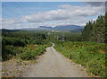
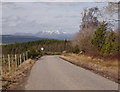
Road descending to Foxhole
by Craig Wallace geograph for square NH5237 Next to the Abriachan junction, at the top of the hill. This road heads down... (more)
|
|
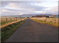
Braes of Balnabeen road
by Craig Wallace geograph for square NH5856 Looking back down the road towards the junction with the B9169, a few houses and... (more)
|
|
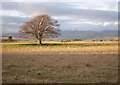
Fields, Brae of Balnabeen
by Craig Wallace geograph for square NH5955 A lone tree in a field.
A view towards Ben Wyvis, though much of the hill is... (more)
|
|
Harvested fields, by Wester Craggach
by Craig Wallace geograph for square NH5643 A view across a harvested and baled field, from a farm track between Mid... (more)
|
|
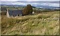
Abandoned house, Letter
by Craig Wallace geograph for square NH5640 I don't know anything about the history of this house, or how long it has... (more)
Tags:
Abandoned HouseX
top:Derelict, DisusedX
top:Housing, DwellingsX
top:MoorlandX
View of Ben Wyvis
|
|
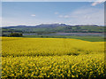
Yellow fields, by Ferintosh
by Craig Wallace geograph for square NH5757 Looking across a field of oil seed rape, towards the Cromarty Firth and... (more)
Tags:
top:Farm, Fishery, Market GardeningX
FieldX
top:Flat LandscapesX
type:GeographX
Oilseed RapeX
View of Ben Wyvis
|
|
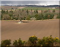
Fields by Crochar
by Craig Wallace geograph for square NH5958 A ploughed field near Culbokie, on the northern side of the Black Isle. Sloping... (more)
Tags:
top:Farm, Fishery, Market GardeningX
type:GeographX
top:LowlandsX
Ploughed FieldX
View of Ben Wyvis
|
|
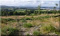
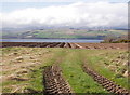
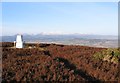
Summit of Cnoc Croit na Maoile
by Craig Wallace geograph for square NH4949 There is a small path through the heather to the summit of this hill. The trig... (more)
|
|
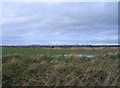
Farmland and railway by the firth
by Craig Wallace geograph for square NH5646 Low-lying farmland on the south shore of the Beauly Firth, near Balcarse.... (more)
Tags:
top:CoastalX
top:Farm, Fishery, Market GardeningX
top:LowlandsX
top:RailwaysX
top:Rivers, Streams, DrainageX
View of Ben Wyvis
|
|
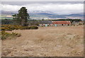
House by Knockbain
by Craig Wallace geograph for square NH6157 Looking across a rough field to an old house, shed and Scots pine tree. Ben... (more)
Tags:
type:GeographX
plant:GorseX
top:GrasslandX
top:Heath, ScrubX
HouseX
top:Housing, DwellingsX
tree:Scots PineX
ShedX
View of Ben Wyvis
|
|
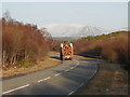
East on the A832, by Grudie
by Craig Wallace geograph for square NH3061 The A832 is a rather wide road with gradual curves, though not very busy.
A... (more)
Tags:
road:A832X
Birch WoodlandX
type:GeographX
top:Roads, Road TransportX
Timber LorryX
View of Ben Wyvis
top:Woodland, ForestX
|
|
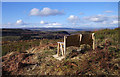
Cleared forest, Battan
by Craig Wallace geograph for square NH5338 A large cleared area, looks like it was felled a few years ago.
|