|
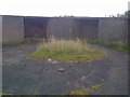
Remains of WW2 Defences
by Mick Garratt
geograph for square NG8689
Light Anti Aircraft guns I think.
|
|
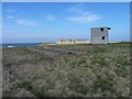
Coastal defences WW2
by James Allan
geograph for square HY5411
Observation tower and remains of other WW2 defence buildings at Rerwick Head.
|
|
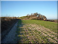
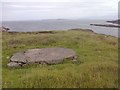
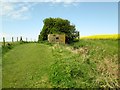
Round Barrow with WW2 gun emplacement, north of West Down
by Vieve Forward
geograph for square SU0669
Bronze Age round barrow with Second World War gun emplacement.... (more)
|
|
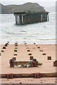
Remains of Pier, Mellon Charles
by Mick Garratt
geograph for square NG8491
Part of the main base for the WW2 defences of Loch Ewe. The far structure is... (more)
|
|
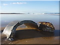
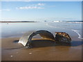
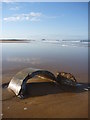
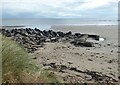
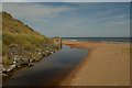
Coastal East Lothian : Concrete, Belhaven Sands
by Richard West
geograph for square NT6579
Uncovered by recent rough seas, the remnants of the concrete pipe/drum base of a... (more)
|
|
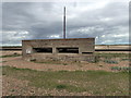
Foundations of RAF Observation Post
by Mick Garratt
geograph for square NG8797
Overlooking the entrance to Guinard Bay and the Summer Isles.
|
|
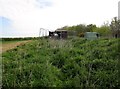
Rye Harbour WW2 Defences
by PAUL FARMER
geograph for square TQ9418
|
|
Coastal East Lothian : Belhaven Bay
by Richard West
geograph for square NT6579
|
|
Coastal East Lothian : Belhaven Sands
by Richard West
geograph for square NT6579
|
|
On Exmouth seafront, WW2 defences
by David Smith
geograph for square SY0080
An Allen-Williams steel turret used to protect a Home Guard member who was armed... (more)
|
|
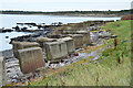
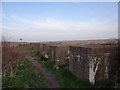
Anti-tank blocks, Fernyness
by Jim Barton
geograph for square NT4477
Part of the east coast defences placed during WW2 as a precaution against invasion.
|
|
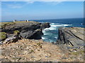
Coastal rocks
by James Allan
geograph for square HY5411
Looking towards Rerwick head and the remains of WW1 and WW2 defences.
|
|
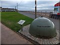
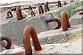
Concrete Holding Down Blocks
by Mick Garratt
for square NG8491
I guess these were weights laid on the loch floor to anchor the anti submarine... (more)
|
|
Sea defences at Low Hauxley
by Russel Wills
geograph for square NU2802
A combination of WW2 concrete and recently quarried rocks.
|
|
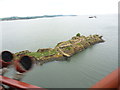
Fortress Scotland : Inch Garvie
by Richard West
geograph for square NT1379
WW1 and WW2 structures abound on Inch Garvie.
|
|
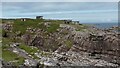
Rubha nan Sasan
by Sandy Gerrard
geograph for square NG8192
World War 2 defences at Rubha nan Sasan. These emplacements guarded the entrance... (more)
|
|
Pillbox at Petten's Links, Aberdeenshire
by Andrew Tryon
geograph for square NJ9819
A concrete pillbox, most likely a beach defence from the second world war. The... (more)
|
|
WWII defences near Trimingham
by Hugh Venables
geograph for square TG2838
|
|
WW2 buildings NW of the Arctic Convoy Memorial
by Martin Dawes
geograph for square NG8192
This whole headland was a military camp covering the entrance into Loch Ewe
|
|
WW2 Pillbox in an arable field at Southfield House Farm
by Martin Dawes
geograph for square TA1854
On a raised position on The Hold has a commanding coverage of the beach at Withow Gap
|
|
WW2 Pillbox near Withow Gap
by Martin Dawes
geograph for square TA1854
The cut path to the left is the farm trail from Southfield House which brings... (more)
|

|
Northern Rock between Nigg Pier and the north Sutor
by valenta
geograph for square NH7968
After sailing from the nearby Nigg graving dock, the pilot boat Nigg Bay... (more)
|
|
Underground Monitoring Site and Visual Spotting Post
by Martin Dawes
geograph for square TA1754
The entrance to the Royal Observer Corps underground monitoring post is to the... (more)
|
|
Reinforcements
by Ian Paterson
geograph for square TQ0101
Concrete blocks alongside the public footpath presumably from wartime.
|
|
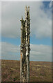
Anti-glider pole, Hamel Down
by Derek Harper
for square SX7079
"Pine poles like this were erected all over Hamel Down in 1939-40 to... (more)
|