|
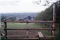
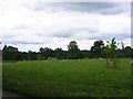
Marston of the Priors - Priors Marston, Warwickshire
by Martin Richard Phelan
geograph for square SP4857
Looking down from the Welsh Road East to the village of Priors Marston, backed... (more)
|
|
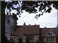
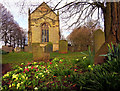
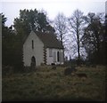
St Mary's Church - Haseley, Warwickshire
by Martin Richard Phelan
for square SP2368
This is the church of St Mary in the scattered Warwickshire village of Haseley... (more)
|
|
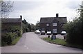
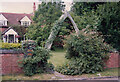
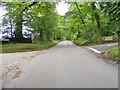
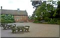
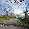
Holly Bush in the Lane - Priors Marston, Warwickshire
by Martin Richard Phelan
geograph for square SP4857
Ahead stands the Holly Bush Inn, in Holly Bush Lane in the Warwickshire village... (more)
|
|
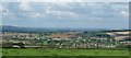
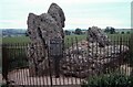
View north-northwest from near to the King Stone
by Rob Farrow
for square SP2832
The King Stone, the most northerly ancient monument of the Rollright Stones, is... (more)
|
|
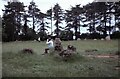
Whispering Knights at Rollright - Long Compton, Warwickshire
by Martin Richard Phelan
geograph for square SP2930
The cluster of stones who are said to have been the Whispering Knights who were... (more)
|
|
King's Men at Rollright - Long Compton, Warwickshire
by Martin Richard Phelan
geograph for square SP2930
The King's Men who are supposed to have been members of his army - that is... (more)
|
|
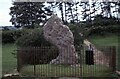
King's Stone at Rollright - Long Compton, Warwickshire
by Martin Richard Phelan
geograph for square SP2930
The King who set out with his army intending to conquer England, until he met... (more)
|
|
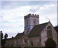
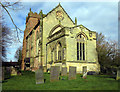
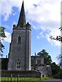
St Lawrence's Church - Rowington, Warwickshire
by Martin Richard Phelan
geograph for square SP2069
In this scattered Warwickshire village of Rowington stands the church of St... (more)
|
|
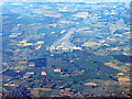
Gaydon Airfield
by M J Richardson
for square SP3554
As seen from the air, with the M11 running across the centre.
|
|
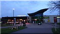
Corley Services
by Steven Haslington
geograph for square SP3086
The entrance to Corley Services, a service station on the M6 motorway in the... (more)
|
|
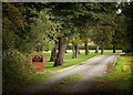
Bradley Green Cottage
by Gillie Rhodes
geograph for square SK2800
The driveway to Bradley Green Cottage, Bradley Green Warwickshire.
This lane is... (more)
|
|
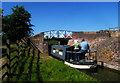
Canal bridge, Warwickshire
by Jim Osley
geograph for square SP1868
Navigating through Bridge no. 48 - Finwood Bridge - Stratford upon Avon Canal.
|
|
Whalebone in Arden - Tanworth in Arden, Warwickshire
by Martin Richard Phelan
geograph for square SP1170
From the days when I would walk at least 20 miles every Saturday. Here in... (more)
|
|
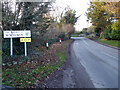
B4085 entering Cleeve Prior
by Chris Allen
geograph for square SP0849
Entering the Wychavon district of Worcestershire from Warwickshire
|
|
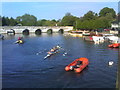
Evening Row
by Gordon Griffiths
geograph for square SP2054
The view towards Clopton Bridge on the River Avon.
|
|
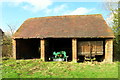
Barn at Lodge Farm, Astley, Warwickshire.
by Hazel Clarke
geograph for square SP3190
This building us part of Lodge Farm, and can be seen near to the footpath that... (more)
|
|
St Mary the Virgin Church, Astley, Warwickshire.
by Hazel Clarke
geograph for square SP3189
An early spring morning at Astley church.
|
|
St. Mary the Virgin Church, Astley, Warwickshire.
by Hazel Clarke
geograph for square SP3189
|
|
Packwood Lane Junction
by Gordon Griffiths
geograph for square SP1771
The junction with Rising Lane in Warwickshire.
|
|
Punchbowl Pub View
by Gordon Griffiths
geograph for square SP1872
The view from Rising Lane in Warwickshire.
|
|
Baddesley Drive View
by Gordon Griffiths
geograph for square SP2072
The view near Baddesley Clinton House, Warwickshire.
|
|
Netherwood Lane Junction
by Gordon Griffiths
geograph for square SP1972
The view near Baddesley Clinton House, Warwickshire.
|
|
B4439 Junction
by Gordon Griffiths
geograph for square SP1671
The view from Wharf Lane in Warwickshire.
|
|
Wharf Lane
by Gordon Griffiths
geograph for square SP1571
The view near Nuthurst in Warwickshire.
|
|
Courtyard Scene
by Gordon Griffiths
geograph for square SP1772
The view in the grounds of Packwood House in Warwickshire.
|
|
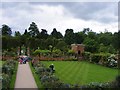
Packwood Garden
by Gordon Griffiths
geograph for square SP1772
The view of the grounds of Packwood House in Warwickshire.
|
|
Packwood Time
by Gordon Griffiths
for square SP1772
The view in the grounds of Packwood House in Warwickshire.
|
|
Lapworth Church
by Gordon Griffiths
geograph for square SP1671
The view of the Church of St Mary the Virgin in the Warwickshire Village.
|
|
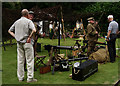
At St.Johns House Museum
by Peter Trimming
geograph for square SP2865
Housed in a Jacobean mansion, St Johns Museum showcases the social history... (more)
|
|
Up Windmill Hill
by John Sutton
geograph for square SP3459
South Warwickshire early on an April evening.
|
|
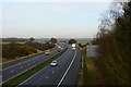
M42 motorway
by Oliver Mills
geograph for square SK2604
Taken from an overhead bridge, near Bramcote Hall Farm, Warwickshire.
|
|
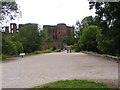
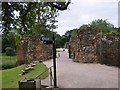
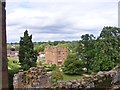
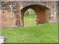
Kenilworth Entrance
by Gordon Griffiths
geograph for square SP2772
The view in Kenilworth Castle, Warwickshire.
|
|
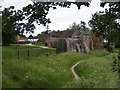
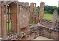
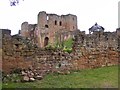
Castle Walls
by Gordon Griffiths
geograph for square SP2772
The view in Kenilworth Castle, Warwickshire.
|
|
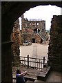
Castle Path
by Gordon Griffiths
geograph for square SP2772
The view from inside Kenilworth Castle, Warwickshire.
|
|
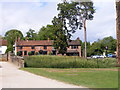
Kenilworth Pub
by Gordon Griffiths
geograph for square SP2772
The view of the Queen and Castle from Kenilworth Castle, Warwickshire.
|
|
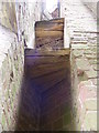
Kenilworth Stairs
by Gordon Griffiths
for square SP2772
The view in Kenilworth Castle, Warwickshire.
|
|
Kenilworth Scene
by Gordon Griffiths
geograph for square SP2772
The view of the Gatehouse in Kenilworth Castle, Warwickshire.
|
|
Kenilworth Hall
by Gordon Griffiths
geograph for square SP2772
The view in Kenilworth Castle, Warwickshire.
|
|
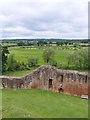
Wall View
by Gordon Griffiths
geograph for square SP2772
The view from Kenilworth Castle, Warwickshire.
|
|
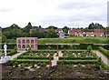
Garden View
by Gordon Griffiths
geograph for square SP2772
The view in Kenilworth Castle, Warwickshire.
|
|
Castle Scene
by Gordon Griffiths
geograph for square SP2772
The view in Kenilworth Castle, Warwickshire.
|
|
Castle Water Gate
by Gordon Griffiths
for square SP2772
The view in Kenilworth Castle, Warwickshire.
|
|
Castle Walls
by Gordon Griffiths
geograph for square SP2772
The view in Kenilworth Castle, Warwickshire.
|
|
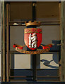
Warwickshire coat of arms, Shire Hall, Warwick
by Jim Osley
for square SP2864
|
|
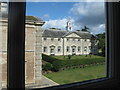
East wing at Compton Verney
by Dave Pickersgill
geograph for square SP3152
The east wing at Compton Verney, a manor and parish in Warwickshire, England.
|
|
An Art House?
by Dave Pickersgill
geograph for square SP3152
Compton Verney is a manor and parish in Warwickshire, England. The house is an... (more)
|
|
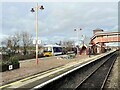
Stratford-upon-Avon Station
by Adrian Taylor
geograph for square SP1955
A Chiltern Railways Class 165 number 165018 diesel train waits in Platform 3... (more)
|

|
Base of floodlight, Edgbaston
by Robin Stott
geograph for square SP0684
One of the entrances to the Warwickshire County Cricket Ground is on the right;... (more)
|
|
Bassetts Pole pub and roundabout - Canwell, Staffordshire
by Martin Richard Phelan
geograph for square SP1499
Here beside the A453 Tamworth Road looking across to the pub and roundabout. The... (more)
|
|
St James' Church - Alveston, Warwickshire
by Martin Richard Phelan
geograph for square SP2356
The 18th century chancel of the old church of St (Saint) James was all that was... (more)
|