Public Tags
Tag: Weybridge
Showing latest 50 of 168 images tagged with Weybridge tag.
|
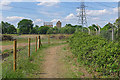
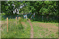
Footpath to Weybridge
by Alan Hunt geograph for square TQ0663 The path from the Byfleet Road to Weybridge with the mill buildings on the Wey... (more)
|
|
Thames Towpath near Weybridge
by Alan Hunt geograph for square TQ0866 The towpath along the Desborough Cut between Weybridge and Walton-on-Thames.
|
|
D'Oyly Carte Island, Weybridge
by Alan Hunt geograph for square TQ0765 Boat moorings on the eastern end of D'Oyly Carte Island in the Thames at Weybridge.
|
|
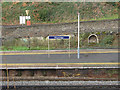
Weybridge station
by Alan Hunt geograph for square TQ0763 Weybridge station from the footpath that follows the lines to Lonsdale Road.
|
|
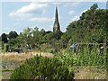
Weybridge allotments
by Alan Hunt geograph for square TQ0764 The allotments in the Churchfields area of Weybridge with the spire of St James... (more)
|
|
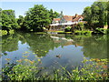
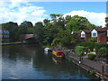
The Thames at Weybridge
by Alan Hunt geograph for square TQ0765 Looking across the Thames from the Weybridge side towards the ferry station in... (more)
|
|
River Wey, Weybridge
by Alan Hunt geograph for square TQ0664 A canal boat turning in the basin near Weybridge lock which marks the junction... (more)
Tags:
top:Rivers, Streams, DrainageX
place:Weybridge
|
|
Weybridge - River Wey Navigation
by Colin Smith geograph for square TQ0664 National Trust noticeboard beside the waterway at the west end of a road bridge... (more)
Tags:
type:GeographX
top:Roads, Road TransportX
subject:SignX
top:Sport, LeisureX
top:Suburb, Urban FringeX
place:Weybridge
|
|
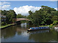
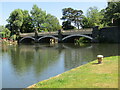
Weybridge - Wey Bridge
by Colin Smith geograph for square TQ0664 The newest bridge carrying the main Weybridge-Addlestone road over the River Wey... (more)
Tags:
subject:BridgeX
top:CanalsX
type:GeographX
River Wey NavigationX
top:Rivers, Streams, DrainageX
top:Roads, Road TransportX
place:Weybridge
|
|
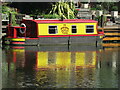
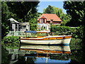
Weybridge - The Iron Duck
by Colin Smith for square TQ0664 Narrowboat moored in Weybridge's Wharf Pool where Wey barges once plied... (more)
Tags:
subject:BoatX
top:CanalsX
type:Close LookX
NarrowboatX
River Wey NavigationX
top:Rivers, Streams, DrainageX
top:Sport, LeisureX
place:Weybridge
|
|
Weybridge - Wey Bridge
by Colin Smith geograph for square TQ0664 The old Addlestone-Weybridge main road now uses a new bridge (behind camera).... (more)
Tags:
subject:BridgeX
top:CanalsX
type:GeographX
top:Historic Sites and ArtefactsX
River Wey NavigationX
top:Rivers, Streams, DrainageX
top:Roads, Road TransportX
place:Weybridge
|
|
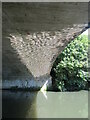
Weybridge - Ripple Effect
by Colin Smith for square TQ0664 Light playing on the underside of the arch where the A317 Weybridge Road crosses... (more)
Tags:
subject:BridgeX
type:Close LookX
River Wey NavigationX
top:Rivers, Streams, DrainageX
top:Roads, Road TransportX
place:Weybridge
|
|
Weybridge - River Wey
by Colin Smith geograph for square TQ0664 The Wey forms the western limit of Weybridge as the Navigation flows between... (more)
Tags:
top:CanalsX
type:GeographX
subject:RiverX
River Wey NavigationX
top:Rivers, Streams, DrainageX
top:Suburb, Urban FringeX
place:Weybridge
|
|
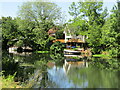
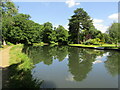
Weybridge - River Wey Navigation
by Colin Smith geograph for square TQ0664 Reflective scene in affluent Weybridge. Pleasure boats have long replaced the... (more)
Tags:
subject:BoatX
top:CanalsX
type:GeographX
River Wey NavigationX
top:Rivers, Streams, DrainageX
top:Sport, LeisureX
place:Weybridge
|
|
Weybridge - River Wey Navigation
by Colin Smith for square TQ0664 Waterside with a Dutch flair between Weybridge's Town and Thames Locks.... (more)
Tags:
top:CanalsX
type:Cross GridX
subject:RiverX
River Wey NavigationX
top:Rivers, Streams, DrainageX
top:Suburb, Urban FringeX
place:Weybridge
|
|
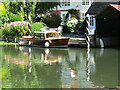
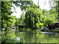
Weybridge - Vaporetto
by Colin Smith geograph for square TQ0665 Little Venice on the River Wey Navigation at upmarket Weybridge.
Link
Tags:
BoatX
top:CanalsX
type:GeographX
subject:MooringX
River Wey NavigationX
top:Rivers, Streams, DrainageX
top:Sport, LeisureX
place:Weybridge
|
|
Weybridge - River Wey Navigation
by Colin Smith geograph for square TQ0665 The northernmost section of the waterway is between Weybridge's Town and... (more)
Tags:
top:CanalsX
type:GeographX
subject:RiverX
River Wey NavigationX
top:Rivers, Streams, DrainageX
top:Suburb, Urban FringeX
place:Weybridge
|
|
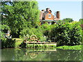
Weybridge - Tumbling Weir
by Colin Smith geograph for square TQ0765 One of the weirs between Thames and Town Locks at Weybridge, built to aid flood... (more)
|
|
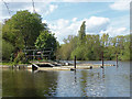
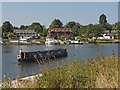
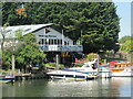
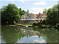
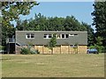
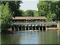
Weybridge Mariners
by Colin Smith geograph for square TQ0765 Seen from Thames Street in Weybridge, across an arm of the River Thames, is the... (more)
Tags:
subject:Boat HouseX
BoathouseX
type:GeographX
River ThamesX
top:Rivers, Streams, DrainageX
top:Sport, LeisureX
place:Weybridge
|
|
Weybridge Mariners Club
by Colin Smith geograph for square TQ0765 View from Thames Street in Weybridge, across an arm of the River Thames, towards... (more)
Tags:
BoathouseX
top:Business, Retail, ServicesX
type:GeographX
subject:RiverX
River ThamesX
top:Rivers, Streams, DrainageX
top:Suburb, Urban FringeX
place:Weybridge
|
|
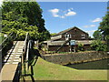
Weybridge Rowing Club
by Colin Smith geograph for square TQ0765 Historic club at Jessamy Road, Thames Lock in Weybridge.
Link
Tags:
subject:Boat HouseX
FootbridgeX
type:GeographX
top:Historic Sites and ArtefactsX
Rowing ClubX
top:Sport, LeisureX
place:Weybridge
|
|
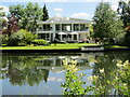
Weybridge - River Wey Navigation
by Colin Smith geograph for square TQ0665 Mooring and select housing in an upmarket riparian Weybridge.
Link
Tags:
top:CanalsX
type:GeographX
top:Housing, DwellingsX
subject:MooringX
River Wey NavigationX
top:Rivers, Streams, DrainageX
top:Sport, LeisureX
place:Weybridge
|
|
Weybridge - River Wey Navigation
by Colin Smith geograph for square TQ0665 Sylvan stretch between the Thames and Town Locks at Weybridge.
Link
Tags:
top:CanalsX
type:GeographX
subject:RiverX
River Wey NavigationX
top:Rivers, Streams, DrainageX
top:Suburb, Urban FringeX
place:Weybridge
|
|
Weybridge - River Wey Navigation
by Colin Smith geograph for square TQ0665 The towpath on the northernmost reach of the River Wey Navigation passes an... (more)
Tags:
top:CanalsX
type:GeographX
top:Housing, DwellingsX
subject:RiverX
River Wey NavigationX
top:Rivers, Streams, DrainageX
place:Weybridge
|
|
Weybridge - River Wey Navigation
by Colin Smith geograph for square TQ0665 The towpath on the northernmost reach of the River Wey Navigation passes an... (more)
|
|
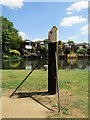
Weybridge - Winding Post
by Colin Smith geograph for square TQ0664 Historic canalside metal post at Weybridge's Wharf Pool. Here barges were... (more)
Tags:
top:CanalsX
type:GeographX
top:Historic Sites and ArtefactsX
subject:PostX
River Wey NavigationX
top:Rivers, Streams, DrainageX
place:Weybridge
|
|
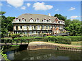
Weybridge - Admiral Stirling Court
by Colin Smith geograph for square TQ0664 Attractive modern housing facing Weybridge's historic Wharf Pool on the... (more)
Tags:
subject:Apartment BlockX
top:CanalsX
type:GeographX
top:Housing, DwellingsX
River Wey NavigationX
top:Rivers, Streams, DrainageX
top:Suburb, Urban FringeX
place:Weybridge
|
|
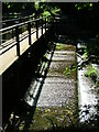
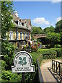
Weybridge - Weyside Path
by Colin Smith geograph for square TQ0664 The towpath following the River Wey Navigation here passes Weybridge's... (more)
Tags:
type:GeographX
top:Housing, DwellingsX
National Trust SignX
subject:PathX
top:PathsX
River Wey NavigationX
top:Sport, LeisureX
top:Suburb, Urban FringeX
place:Weybridge
|
|
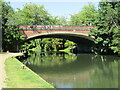
Weybridge - Wey Bridge
by Colin Smith geograph for square TQ0664 Approaching Weybridge Lock Bridge from the west. This three arched bridge was... (more)
Tags:
subject:BridgeX
type:GeographX
top:Roads, Road TransportX
top:Suburb, Urban FringeX
place:Weybridge
|
|
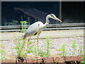
Weybridge - Heron
by Colin Smith for square TQ0664 Patiently fishing at Weybridge Business Park at a wharf on the River Wey... (more)
Tags:
subject:BirdX
type:Close LookX
bird:HeronX
place:Weybridge
top:Wild Animals, Plants and MushroomsX
|
|
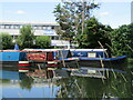
Weybridge - Wey Navigation
by Colin Smith geograph for square TQ0664 Narrowboats moored at Pelican Wharf, Weybridge Business Park.
Tags:
top:Business, Retail, ServicesX
top:CanalsX
type:GeographX
NarrowboatsX
subject:RiverX
River Wey NavigationX
top:Rivers, Streams, DrainageX
top:Sport, LeisureX
place:Weybridge
|
|
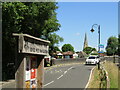
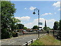
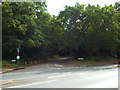
Locke King Road, near Weybridge
by Malc McDonald geograph for square TQ0762 Locke King Road on the outskirts of Weybridge, in Surrey.
|
|
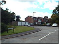
Julian Hill, Weybridge
by Malc McDonald geograph for square TQ0763 Julian Hill is a small housing development on the outskirts of Weybridge, in Surrey.
|
|
Cobbett's Hill, Weybridge
by Malc McDonald geograph for square TQ0763 Cobbett's Hill leads through woodland to a housing development close in Weybridge.
|
|
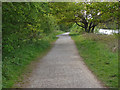
Footpath to Weybridge
by Alan Hunt geograph for square TQ0663 The footpath from the Byfleet Road to Weybridge approaching the railway crossing... (more)
|
|
Weybridge station
by Alan Hunt geograph for square TQ0763 A signpost on the platform of Weybridge station with the car park in the background.
|
|
Rowing club, Weybridge
by Alan Hunt geograph for square TQ0765 The boathouse of the Weybridge Ladies Amateur Rowing Club on the towpath... (more)
|
|
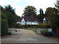
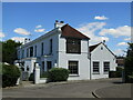
Southfield Place, Weybridge
by Malc McDonald geograph for square TQ0763 Southfield Place is a private road on the outskirts of Weybridge, in Surrey.
Tags:
GateX
type:GeographX
subject:Housing EstateX
Private Access RoadX
housing:Private DevelopmentX
Private EstateX
Private Housing EstateX
Private PropertyX
Private RoadX
top:Suburb, Urban FringeX
county:SurreyX
near:Weybridge
gate:WoodenX
Wooden GateX
|
|
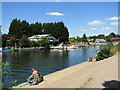
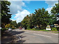
Thames Street, Weybridge
by Alan Hunt geograph for square TQ0765 Looking south along Thames Street from the small car park by the towpath.
Tags:
top:Roads, Road TransportX
place:Weybridge
|
|
Moorings, River Wey
by Alan Hunt geograph for square TQ0664 Moorings along the basin below Weybridge Lock. The bridge carrying the A317 can... (more)
Tags:
top:Rivers, Streams, DrainageX
place:Weybridge
|
|
Weybridge - Weir
by Colin Smith geograph for square TQ0765 This weir runs between two small islands in the River Thames - Hamhaugh Island... (more)
|
|
Weybridge - The Minnow
by Colin Smith geograph for square TQ0765 Upmarket restaurant on Thames Street, close to where the River Wey flows into the Thames.
|
|
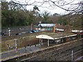
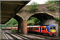
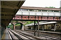
Weybridge Railway Station
by Peter Trimming geograph for square TQ0763 Train arriving at platform 3.
|
|
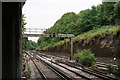
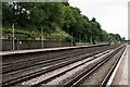
Weybridge Railway Station
by Peter Trimming geograph for square TQ0763 View from the end of platform 2.
|
|
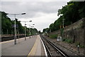
Weybridge Railway Station
by Peter Trimming geograph for square TQ0763 View from platform 2.
|
|
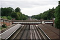
Weybridge Railway Station
by Peter Trimming geograph for square TQ0763 View from platform 2.
|
|
Weybridge Railway Station
by Peter Trimming geograph for square TQ0763 View from platform 1.
|
|
Weybridge Railway Station
by Peter Trimming geograph for square TQ0763 Seen from Brooklands Road.
|
|
Weybridge Railway Station
by Peter Trimming geograph for square TQ0763 Seen from Brooklands Road, with a train departing from platform 3.
|
|
River Wey
by Alan Hunt geograph for square TQ0663 The River Wey between Byfleet and Weybridge in an area of former gravel pits,
|