Public Tags
Showing images tagged with area:Aston tag.
|
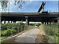
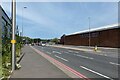
Road, rail and river, Aston
by Robin Stott geograph for square SP0890 Birmingham's Cross-City line breezes through the forest of concrete pillars... (more)
Tags:
road:A38(M)X
area:Aston
postcode district:B6X
place:BirminghamX
FlyoverX
type:GeographX
top:LowlandsX
top:PathsX
top:RailwaysX
top:Rivers, Streams, DrainageX
top:Roads, Road TransportX
Salford ParkX
near:Spaghetti JunctionX
top:Suburb, Urban FringeX
|
|
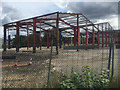
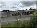
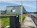
Steel frame near Long Acre, Aston, Birmingham
by Robin Stott geograph for square SP0889 An aerial photo shows the building complete. Photographed from a Lichfield-New... (more)
Tags:
area:Aston
postcode area:B7X
place:BirminghamX
top:Construction, DevelopmentX
type:GeographX
Industrial EstateX
top:LowlandsX
top:Suburb, Urban FringeX
|
|
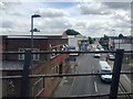
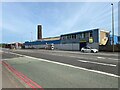
East on Aston Hall Road, Aston, Birmingham
by Robin Stott geograph for square SP0889 Photographed from a Lichfield-New Street London Midland train.
Tags:
area:Aston
postcode area:B6X
place:BirminghamX
type:GeographX
Industrial EstateX
top:IndustryX
top:LowlandsX
top:Roads, Road TransportX
top:Suburb, Urban FringeX
|
|
Waterworks Street, Aston
by Robin Stott geograph for square SP0889 In line with Waterworks Street and Aston Hall Road beyond is the spire of St... (more)
|

|
Aston Reservoir, Birmingham
by Robin Stott geograph for square SP0990 Originally fed by the River Tame to supply drinking water, the reservoir forms... (more)
Tags:
area:Aston
near:AstonX
postcode district:B6X
place:BirminghamX
type:GeographX
top:LowlandsX
top:Park and Public GardensX
Salford ParkX
near:Spaghetti JunctionX
top:Suburb, Urban FringeX
top:Water ResourcesX
|

|
Looking east, Salford Park, Birmingham
by Robin Stott geograph for square SP0890 Towards the end of NoMow May grasses and wildflowers form a natural setting for... (more)
Tags:
area:Aston
near:AstonX
postcode district:B6X
place:BirminghamX
type:GeographX
top:LowlandsX
top:Park and Public GardensX
Salford ParkX
Spaghetti JunctionX
top:Suburb, Urban FringeX
top:Water ResourcesX
|
|
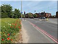
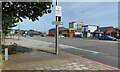
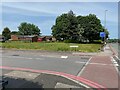
Aston Hall Road joins Lichfield Road, Aston
by Robin Stott geograph for square SP0989 No Mow May has produced some good results here.
Image reference: 7512076
Tags:
road:A5127X
area:Aston
road:B4137X
postcode district:B6X
place:BirminghamX
type:GeographX
top:LowlandsX
No Mow MayX
PoppiesX
top:Roads, Road TransportX
top:Suburb, Urban FringeX
Yellow FlowersX
|
|
Northeast on Lichfield Road, Aston
by Robin Stott geograph for square SP0889 Lichfield Road A5127 runs between the Aston Expressway A38 (M) and M6 at... (more)
|
|
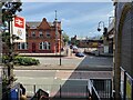
Southwest on Lichfield Road, Aston
by Robin Stott geograph for square SP0889 The view is under the railway bridge at Aston station. The tall building looks... (more)
Tags:
area:Aston
postcode district:B6X
place:BirminghamX
top:Business, Retail, ServicesX
Closed PubX
type:GeographX
top:LowlandsX
top:Suburb, Urban FringeX
|
|
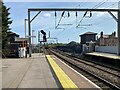
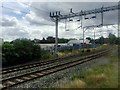
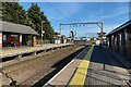
South at Aston Station, Birmingham
by Robin Stott geograph for square SP0889 Aston is on the Cross-City Line between Redditch, Bromsgrove and Lichfield. A... (more)
Tags:
area:Aston
postcode district:B6X
place:BirminghamX
type:GeographX
top:LowlandsX
Railway StationX
top:RailwaysX
top:Suburb, Urban FringeX
|
|
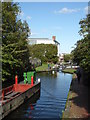
Birmingham & Fazeley Canal - Aston flight of locks
by Chris Allen for square SP0888 A working boat ensemble is approaching one of the locks on the Aston flight.
Tags:
area:Aston
canal:Birmingham and FazeleyX
subject:CanalX
top:CanalsX
type:Cross GridX
canal:LockX
canal:Lock FlightX
|
|
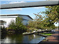
Birmingham & Fazeley Canal - Aston flight
by Chris Allen geograph for square SP0788 This is the lack downstream of Waterlinks Bridge. The big shed on the left is... (more)
|
|
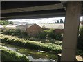
River Tame below the Aston Expressway, Aston, Birmingham
by Robin Stott geograph for square SP0890 The river, flowing away from the camera, has taken a sharp turn northeast.... (more)
Tags:
road:A38(M)X
area:Aston
place:BirminghamX
CanalisedX
Elevated MotorwayX
type:GeographX
top:LowlandsX
top:RailwaysX
top:Rivers, Streams, DrainageX
top:Roads, Road TransportX
top:Suburb, Urban FringeX
river:TameX
|
|
Power League, Salford Park, Aston
by Robin Stott for square SP0990 The area occupied by Power League is also known as Salford Stadium. Pictured are... (more)
Tags:
area:Aston
postcode district:B6X
place:BirminghamX
type:Cross GridX
top:LowlandsX
Power LeagueX
Salford ParkX
Salford StadiumX
near:Spaghetti JunctionX
top:Sport, LeisureX
Sports CentreX
top:Suburb, Urban FringeX
|

|
Power League entrance, Salford Park, Aston
by Robin Stott geograph for square SP0989 Power League occupies a large area on the south side of the park. It offers... (more)
Tags:
area:Aston
postcode district:B6X
place:BirminghamX
type:GeographX
top:LowlandsX
Power LeagueX
top:Sport, LeisureX
Sports CentreX
top:Suburb, Urban FringeX
|
|
Ramp up to Long Acre, Aston, Birmingham
by Robin Stott geograph for square SP0889 Photographed from a Lichfield-New Street train.
Tags:
area:Aston
postcode area:B7X
place:BirminghamX
DistributionX
type:GeographX
top:IndustryX
top:LowlandsX
top:Suburb, Urban FringeX
Vehicle RampX
|
|
Line towards Stechford from Aston, Birmingham
by Robin Stott geograph for square SP0889 Stechford is a junction on the main line into Brum from Rugby. Is this one of... (more)
Tags:
area:Aston
postcode area:B7X
place:BirminghamX
type:GeographX
Industrial EstateX
top:LowlandsX
top:RailwaysX
top:Suburb, Urban FringeX
|
|
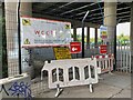
Mixed messages, Gravelly Compound, Aston
by Robin Stott for square SP0890 Highways England operates a depot beneath a Spaghetti Junction flyover. A... (more)
Tags:
area:Aston
postcode district:B6X
place:BirminghamX
type:Close LookX
top:LowlandsX
top:PathsX
top:Roads, Road TransportX
SignsX
near:Spaghetti JunctionX
top:Suburb, Urban FringeX
|
|
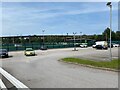
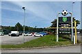
Power League entrance, Aston
by Robin Stott geograph for square SP0989 The sign at the entrance sets out the facilities available at Power League,... (more)
Tags:
area:Aston
postcode district:B6X
place:BirminghamX
Car ParkX
Football ClubX
type:GeographX
top:LowlandsX
Power LeagueX
top:Sport, LeisureX
top:Suburb, Urban FringeX
|
|
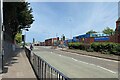
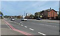
Lichfield Road businesses, Aston
by Robin Stott geograph for square SP0989 Nearing the M6 junction 6. Star City is a cinema and entertainment complex.
Tags:
road:A5127X
area:Aston
postcode district:B6X
place:BirminghamX
top:Business, Retail, ServicesX
Dual CarriagewayX
type:GeographX
top:LowlandsX
Mixed UseX
top:Suburb, Urban FringeX
|
|
South at Aston station, Birmingham
by Robin Stott geograph for square SP0889 Trains arrive from behind the camera from Walsall and Lichfield. At a junction... (more)
Tags:
area:Aston
postcode district:B6X
place:BirminghamX
Birmingham Cross-City LineX
type:GeographX
top:LowlandsX
Railway StationX
top:RailwaysX
top:Suburb, Urban FringeX
|
|
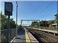
North at Aston station, Birmingham
by Robin Stott geograph for square SP0889 Trains arrive from behind the camera from Redditch and Birmingham New Street.... (more)
Tags:
area:Aston
postcode district:B6X
place:BirminghamX
Birmingham Cross-City LineX
type:GeographX
top:LowlandsX
Railway StationX
top:RailwaysX
top:Suburb, Urban FringeX
|
|
Lichfield Road towards M6, Aston
by Robin Stott geograph for square SP0989 There is a right turn somewhere for Star City SP0989 : Star City.
This image reference: 7512103
Tags:
road:A5127X
area:Aston
postcode district:B6X
place:BirminghamX
type:GeographX
near:Gravelly Hill InterchangeX
top:LowlandsX
Mixed UseX
Near M6 J6X
top:Roads, Road TransportX
near:Spaghetti JunctionX
top:Suburb, Urban FringeX
|
|
By VSN Steels Limited, Lichfield Road, Aston
by Robin Stott geograph for square SP0989 VSN Steels describe themselves as 'Flame cutters' and 'Surface... (more)
|
|
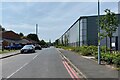
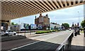
Urban Express Park, Aston
by Robin Stott for square SP0989 The park sits in the angle of Lichfield Road, right, and Waterworks Street,... (more)
Tags:
road:A5127X
area:Aston
postcode district:B6X
place:BirminghamX
Business PremisesX
top:Business, Retail, ServicesX
type:Cross GridX
top:IndustryX
top:LowlandsX
top:Suburb, Urban FringeX
To LetX
|
|
Vacant industrial premises, Aston
by Robin Stott for square SP0989 The south side of Lichfield Road A5127 is lined with lengthy industrial... (more)
Tags:
road:A5127X
area:Aston
postcode district:B6X
place:BirminghamX
type:Cross GridX
top:Derelict, DisusedX
name:Emery BrosX
Factory ChimneyX
Former Metal WorksX
top:IndustryX
top:LowlandsX
top:Roads, Road TransportX
top:Suburb, Urban FringeX
|
|
Sutherland Street housing, Aston
by Robin Stott geograph for square SP0889 On the north side of Lichfield Road there is this small estate of single- and... (more)
Tags:
area:Aston
postcode district:B6X
place:BirminghamX
type:GeographX
top:Housing, DwellingsX
top:LowlandsX
top:Suburb, Urban FringeX
|
|
View from exit, Aston station
by Robin Stott geograph for square SP0889 Across Lichfield Road, Holborn Hill crosses the Birmingham and Fazeley Canal... (more)
Tags:
area:Aston
postcode district:B6X
place:BirminghamX
Birmingham Cross-City LineX
Closed PubX
type:GeographX
top:IndustryX
top:LowlandsX
Metal WorksX
Railway StationX
top:Suburb, Urban FringeX
|