Public Tags
Other tags: near:Cotham
Showing images tagged with area:Cotham tag.
|
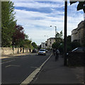
Southwest on Cotham Road at Cotham Park, Cotham, Bristol
by Robin Stott geograph for square ST5874 Cotham Road swings west a few metres along. The shops in view are in Cotham Road... (more)
|
|
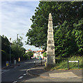
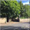
Pair of obelisks at the turn in to Cotham Park, Cotham, Bristol
by Robin Stott geograph for square ST5874 The obelisks marked the entrance to Cotham Park, "developed by Francis and... (more)
|
|
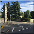
The Cotham Park turn, Cotham Road, Bristol
by Robin Stott geograph for square ST5874 The obelisk is one of a pair, listed grade II.... (more)
|
|
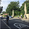
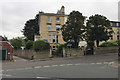
Cotham Road at Cotham Side bus stops, Cotham, Bristol
by Robin Stott geograph for square ST5874 Cotham Side is the turning to the right, location of St Matthew's Church... (more)
|
|
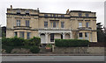
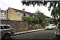
Nos 49, 51 and 53 Cotham Road, Cotham, Bristol
by Robin Stott geograph for square ST5874 A terrace of three houses styled to look like a mansion, built 1855 and listed... (more)
Tags:
place:BristolX
postcode district:BS6X
area:Cotham
type:GeographX
top:Housing, DwellingsX
top:LowlandsX
period:Mid 19th CenturyX
Residential AreaX
top:Suburb, Urban FringeX
|
|
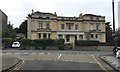
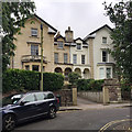
Northeast end of Cotham Road, Cotham, Bristol
by Robin Stott geograph for square ST5874 The house on the right is No.47 Cotham Road, Grade II listed, "Italianate... (more)
Tags:
place:BristolX
postcode district:BS6X
area:Cotham
type:GeographX
top:LowlandsX
period:Mid 19th CenturyX
Residential AreaX
top:Suburb, Urban FringeX
|
|
49, 51 and 53, Cotham Road, Cotham, Bristol
by Robin Stott geograph for square ST5874 Three houses pretending to be one, built 1855. Listed Grade II... (more)
Tags:
place:BristolX
postcode district:BS6X
area:Cotham
type:GeographX
top:Housing, DwellingsX
top:LowlandsX
Residential AreaX
top:Suburb, Urban FringeX
|
|
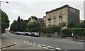
Houses, southeast end of Archfield Road, Cotham, Bristol
by Robin Stott geograph for square ST5874 Seen from the junction with Cotham Grove ST5874 : Cotham Grove. On the left Pitch Lane... (more)
Tags:
place:BristolX
postcode district:BS6X
area:Cotham
type:GeographX
top:Housing, DwellingsX
top:LowlandsX
Residential AreaX
top:Suburb, Urban FringeX
|
|
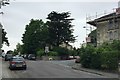
Pitch Lane, Cotham, Bristol
by Robin Stott geograph for square ST5874 A narrow road between Cotham Road and Cotham Grove. Here are two other views of... (more)
|
|
Twentieth-century houses, Cotham Side, Cotham, Bristol
by Robin Stott geograph for square ST5874 Tags:
place:BristolX
postcode district:BS6X
area:Cotham
type:GeographX
top:Housing, DwellingsX
top:LowlandsX
Residential AreaX
top:Suburb, Urban FringeX
|
|
12 and 11 Cotham Side, Cotham, Bristol
by Robin Stott geograph for square ST5874 Tags:
place:BristolX
postcode district:BS6X
area:Cotham
type:GeographX
top:Housing, DwellingsX
top:LowlandsX
Residential AreaX
Semi-Detached HousesX
top:Suburb, Urban FringeX
|
|
South end of Cotham Grove meets Archfield Road, Cotham, Bristol
by Robin Stott geograph for square ST5874 |