Public Tags
Showing images tagged with beach:Sand and Pebble tag.

|
Beach near Boscombe
by Malc McDonald geograph for square SZ1090 A view along the beach between Bournemouth and Boscombe, photographed on a hazy... (more)
Tags:
subject:Beach
Beach
Beach Groyne
near:Boscombe
place:Bournemouth
top:Coastal
type:Geograph
Groyne
beach:Sand
beach:Sand and Pebble
Sand Beach
Sandy Beach
|

|
Groyne on the beach, Bournemouth
by Malc McDonald geograph for square SZ1090 A groyne on the beach between Boscombe and Bournemouth, photographed on a hazy... (more)
Tags:
Beach
Beach Groyne
near:Boscombe
place:Bournemouth
top:Coastal
type:Geograph
Groyne
subject:Groyne
beach:Sand
beach:Sand and Pebble
Sand Beach
Sandy Beach
Wooden Groyne
|

|
Three levels of beach, south of Amble
by Christine Johnstone geograph for square NU2803 Sand dunes above the high tide line, pebbles around the high tide line and sand below it.
Tags:
subject:Beach
top:Coastal
type:Geograph
Grassed Sand Dunes
Low Sand Dunes
beach:Sand and Pebble
|

|
Beach at Morfa Dyffryn, near Dyffryn Ardudwy
by Malc McDonald geograph for square SH5623 Sand and stones exposed by the receding tide at Morfa Dyffryn, on the coast of... (more)
Tags:
near:Barmouth
Beach
subject:Beach
top:Coastal
near:Dyffryn Ardudwy
type:Geograph
county:Gwynedd
near:Harlech
place:Morfa Dyffryn
top:Paths
beach:Sand
beach:Sand and Pebble
Sand and Shingle Beach
Sand Beach
Sandy Beach
country:Wales
ldp:Wales Coast Path
Wales Coast Path
long distance path:Wales Coast Path
|

|
Beach on the east coast of Spurn, at low tide
by Christine Johnstone geograph for square TA4115 Muddy sand above the normal high tide line, pebbles below it.
Tags:
subject:Beach
Beach at Low Tide
top:Coastal
type:Geograph
at:Low Tide
beach:Sand and Pebble
place:Spurn
Spurn Beach
|

|
Beach near St. Anne's-on-the-Sea
by Malc McDonald geograph for square SD3031 A view south along the Fylde coastline near St. Anne's-on-the-Sea.
Tags:
subject:Beach
near:Blackpool
top:Coastal
Coastal Dunes
Coastline
Dunes
type:Geograph
Grassed Sand Dunes
county:Lancashire
beach:Sand
beach:Sand and Pebble
Sand and Shingle Beach
Sand Beach
Sandy Beach
near:Squires Gate
near:St Annes-on-the-Sea
|
|
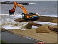
Sand and shingle pumped ashore
by Duncan Graham geograph for square TM1814 As part of the Clacton and Holland-on-Sea Coast Protection Scheme, new beach... (more)
Tags:
Beach
subject:Beach
place:Clacton
place:Clacton-on-Sea
top:Coastal
Coastal Protection
Coastal Protection Scheme
top:Construction, Development
top:Estuary, Marine
type:Geograph
subject:Sand
Sand
beach:Sand and Pebble
subject:Sea Defences
Shingle
|

|
Sand and pebble beach, south of Amble
by Christine Johnstone geograph for square NU2803 About an hour adter low tide.
|

|
Windblown beach, Spurn Point
by Christine Johnstone geograph for square TA4213 The sand is being blown away from under each pebble.
Tags:
subject:Beach
top:Coastal
type:Geograph
National Nature Reserve
beach:Sand and Pebble
place:Spurn
weather:Wind
|

|
Sand and pebble beach
by Pauline E geograph for square NZ8612 View towards Whitby harbour from Sandsend.
Tags:
top:Coastal
beach:Sand and Pebble
|

|
Chalk cliffs, Dykes End
by Pauline E geograph for square TA2169 The beach is a mix of chalk pebbles, sand and rocks at the southern end of Danes Dyke.
|

|
Path from Morfa Dyffryn beach, near Dyffryn Ardudwy
by Malc McDonald geograph for square SH5622 A path leading from Morfa Dyffryn beach on the coast of north Wales.
Tags:
near:Barmouth
Beach Access Path
top:Coastal
near:Dyffryn Ardudwy
type:Geograph
county:Gwynedd
near:Harlech
place:Morfa Dyffryn
subject:Path
Path Away From Beach
Path From Beach
Path to Beach
top:Paths
beach:Sand and Pebble
Sand and Shingle Beach
country:Wales
|

|
Charmouth Beach
by Vieve Forward geograph for square SY3692 |

|
Ebb tide, Sandsend
by Pauline E geograph for square NZ8612 The sandy beach at Whitby becomes more pebble-strewn as you get closer to... (more)
|

|
Beach below Covehithe Cliffs
by Christopher Hilton geograph for square TM5281 |

|
Low tide at Kilnsea beach
by Christine Johnstone geograph for square TA4116 On the horizon is Humber Gateway wind farm.
Tags:
subject:Beach
Beach at Low Tide
top:Coastal
type:Geograph
place:Kilnsea
at:Low Tide
beach:Sand and Pebble
|

|
Rossall Beach
by Steve Daniels geograph for square SD3144 |

|
Rossall Beach
by Steve Daniels geograph for square SD3144 |

|
Charmouth Beach
by Vieve Forward geograph for square SY3692 |

|
Beach at Dykes End, low tide
by Pauline E geograph for square TA2169 It's August and there is a handful of people enjoying the beach today. The... (more)
Tags:
Chalk Cliffs
top:Coastal
Danes Dyke
Nature Reserve
beach:Sand and Pebble
Scheduled Ancient Monument
top:Woodland, Forest
|

|
Herne Bay promenade and shore
by Jim Barton geograph for square TR1868 The rows of wooden groynes are in place to prevent large-scale movement of... (more)
Tags:
top:Coastal
top:Estuary, Marine
type:Geograph
place:Herne Bay
top:Paths
Promenade
beach:Sand and Pebble
Wooden Groynes
|

|
Tracks on the beach, Spurn Point
by Christine Johnstone geograph for square TA4214 Only specialist vehicles can now reach the end of Spurn Point as the lowest part... (more)
Tags:
subject:Beach
top:Coastal
type:Geograph
National Nature Reserve
beach:Sand and Pebble
place:Spurn
Vehicle Tracks
|

|
'Please walk on the seaward side' at Spurn
by Christine Johnstone geograph for square TA4214 A rope and a notice encourage walkers to avoid nesting birds on the estuary side... (more)
Tags:
top:Coastal
type:Geograph
National Nature Reserve
subject:Nature Reserve
beach:Sand and Pebble
place:Spurn
|

|
The narrowest part of Spurn Point
by Christine Johnstone geograph for square TA4214 Covered by the sea in storms and very high tides.
Tags:
subject:Beach
top:Coastal
type:Geograph
Heritage Coast
National Nature Reserve
beach:Sand and Pebble
place:Spurn
|

|
Shingle beach, Herne Bay
by Jim Barton geograph for square TR2068 Wooden groynes to keep in check mass transport of the shingle by wave action.
Tags:
top:Coastal
top:Estuary, Marine
type:Geograph
place:Herne Bay
top:Paths
Promenade
top:Rocks, Scree, Cliffs
beach:Sand and Pebble
Walker
Wooden Groynes
|

|
The receding tide on a stormy day
by Ann Cook geograph for square NX0950 This was an extremely windy day.
|

|
Nun Mill Bay
by Ann Cook geograph for square NX6548 The tide is just beginning to recede.
|

|
Ebb tide, Sandsend
by Pauline E geograph for square NZ8612 View towards the Sandsend Ness headland. Shaped by alum quarrying, the ness is... (more)
Tags:
former:Alum Quarry
top:Coastal
top:Geological Interest
Headland
Ness
top:Quarrying, Mining
beach:Sand and Pebble
Wyke
|
