Public Tags
Tag: Boardwalk
Showing latest 50 of 980 images tagged with Boardwalk tag.
|
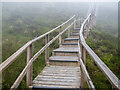
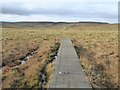
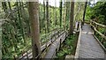
The Cuilcagh Boardwalk
by Rossographer geograph for square H1128 The Cuilcagh Boardwalk, heading high into the mountain. Low mist covers the... (more)
|
|
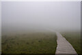
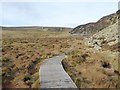
The Cuilcagh Boardwalk
by Rossographer for square H1128 The Cuilcagh Boardwalk, heading high into the mountain. Low mist covers the... (more)
|
|
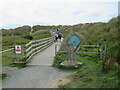
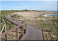
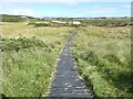
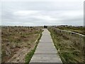
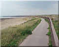
Boardwalk to the beach, near Dyffryn Ardudwy
by Malc McDonald geograph for square SH5722 A boardwalk leading to Morfa Dyffryn beach on the coast of north Wales. The... (more)
Tags:
near:BarmouthX
Beach Access PathX
subject:Boardwalk
Boardwalk
near:Dyffryn ArdudwyX
type:GeographX
county:GwyneddX
near:HarlechX
place:Morfa DyffrynX
Path to BeachX
top:PathsX
country:WalesX
ldp:Wales Coast PathX
Wales Coast PathX
long distance path:Wales Coast PathX
|
|
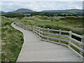
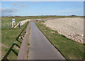
Boardwalk from the beach, Morfa Dyffryn, near Dyffryn Ardudwy
by Malc McDonald geograph for square SH5722 A boardwalk leading away from Morfa Dyffryn beach on the coast of north Wales.... (more)
Tags:
near:BarmouthX
Beach Access PathX
subject:Boardwalk
Boardwalk
top:CoastalX
near:Dyffryn ArdudwyX
type:GeographX
county:GwyneddX
near:HarlechX
place:Morfa DyffrynX
Path Away From BeachX
Path From BeachX
Path to BeachX
top:PathsX
country:WalesX
ldp:Wales Coast PathX
Wales Coast PathX
|
|
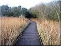
Fowlmere boardwalk
by Mr Ignavy geograph for square TL4045 Category: Boardwalk View of the boardwalk, looking back towards the reception hut. The walk helps... (more)
Tags:
subject:Boardwalk
|
|
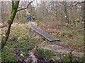
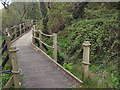
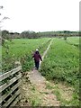
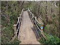
Start of the Boardwalk
by Richard Dorrell geograph for square SX6492 This is the eastern end of the boardwalk.
|
|
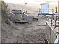
Storm damage to boardwalk, Formby beach
by David Hawgood geograph for square SD2606 Sefton Council had provided an elaborate boardwalk as an easy way down the dunes... (more)
|
|
Boardwalk in Upton Country Park, near Poole
by Malc McDonald geograph for square SY9992 A boardwalk on the edge of Upton Country Park, alongside saltmarshes on Holes... (more)
Tags:
subject:Boardwalk
Boardwalk
near:BournemouthX
top:Estuary, MarineX
type:GeographX
place:Holes BayX
top:PathsX
near:PooleX
long distance path:Poole Harbour TrailX
near:UptonX
place:Upton Country ParkX
|
|
End of the boardwalk
by Jonathan Hutchins geograph for square SJ9223 Tags:
subject:Boardwalk
Boardwalk
type:GeographX
top:Lakes, Wetland, BogX
Local Nature Reserve (LNR)X
Nature ReserveX
Nature Reserve BoardwalkX
top:PathsX
place:StaffordX
|
|
Boardwalk on nature reserve
by Jonathan Hutchins geograph for square SJ9223 Tags:
subject:Boardwalk
Boardwalk
type:GeographX
top:Lakes, Wetland, BogX
Local Nature Reserve (LNR)X
Nature ReserveX
Nature Reserve BoardwalkX
top:PathsX
place:StaffordX
|
|
Flitch Way, near Great Dunmow
by Malc McDonald geograph for square TL6221 A boardwalk on the Flitch Way trail. Here, a small stream runs along the former... (more)
Tags:
near:Bishops StortfordX
subject:Boardwalk
Boardwalk
Boardwalk on PathX
Cycling and Walking TrailX
county:EssexX
Flitch WayX
path:Flitch WayX
Former Railway RouteX
Former Railway Track BedX
Former Railway TrackbedX
Former Railway WalkX
type:GeographX
near:Great DunmowX
top:PathsX
Shared PathX
Shared Use PathX
|
|
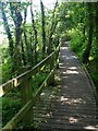
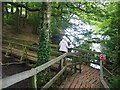
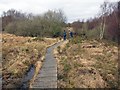
Boardwalk through Roundabout Wood
by John P Reeves geograph for square TQ5940 This boardwalk winds its way through Roundabout Wood and is part of Grosvenor... (more)
|
|
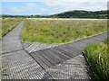
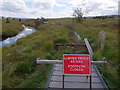
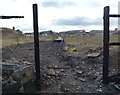
Removed boardwalk segments, Cors Caron
by Rudi Winter geograph for square SN6862 The loop path Link which provides easy... (more)
Tags:
forum:All SquareX
subject:Boardwalk
top:Construction, DevelopmentX
top:Flat LandscapesX
type:GeographX
top:PathsX
|
|
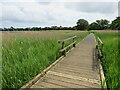
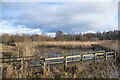
Barton Broad Boardwalk
by G Laird geograph for square TG3520 The boardwalk is a 610 metres loop through a floating forest beside Barton... (more)
|
|
Boardwalk on the Penne Way
by Oliver Dixon geograph for square NY8430 Boardwalks have been constructed on many sections of the Pennine Way to reduce... (more)
|
|
Boardwalk on the Pennine Way below Falcon Clints
by Oliver Dixon geograph for square NY8128 Boardwalks have been constructed on many sections of the Pennine Way to reduce... (more)
|
|
Wales Coast Path boardwalk above Pink Bay (2)
by eswales geograph for square SS7979 The image shows a section of the boardwalk which runs above Pink Bay and Rest... (more)
|
|
Wales Coast Path boardwalk above Pink Bay
by eswales geograph for square SS7979 The northern end of the boardwalk which runs above Pink Bay and Rest Bay. The... (more)
Tags:
Boardwalk
subject:Boardwalk
top:Boundary, BarrierX
top:CoastalX
FenceX
Golf ClubX
Golf CourseX
HandrailX
top:PathsX
Pebble BankX
PebblesX
Public FootpathX
Wales Coast PathX
long distance path:Wales Coast PathX
|
|
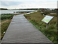
Wales Coast Path boardwalk by the River Kenfig/Afon Cynffig
by eswales geograph for square SS7883 This boardwalk crosses a fairly remote area of wooded wetland bordering the... (more)
Tags:
Boardwalk
subject:Boardwalk
top:Lakes, Wetland, BogX
top:PathsX
Wales Coast PathX
long distance path:Wales Coast PathX
top:Woodland, ForestX
|
|
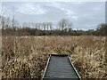
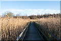
The Lilypad Boardwalk
by Alan Murray-Rust geograph for square SK5437 The boardwalk has been created over an area for the collection of rainwater from... (more)
Tags:
Boardwalk
top:Educational SitesX
top:Lakes, Wetland, BogX
name:Lilypad BoardwalkX
top:Park and Public GardensX
top:PathsX
ReedbedX
top:Suburb, Urban FringeX
Wetland HabitatX
|
|
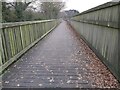
Boardwalk alongside the River Medina near Newport
by Malc McDonald geograph for square SZ5091 A boardwalk alongside the River Medina on the Isle of Wight. The boardwalk is... (more)
Tags:
Boardwalk
subject:Boardwalk
Cycle and Pedestrian PathX
Cycle/Pedestrian RouteX
Cycling and Walking TrailX
top:Estuary, MarineX
FootpathX
type:GeographX
place:Isle of WightX
river:MedinaX
Medina GreenwayX
National Cycle NetworkX
National Cycle Route 22X
NCN22X
near:NewportX
top:PathsX
Public FootpathX
river:River MedinaX
River MedinaX
top:Rivers, Streams, DrainageX
Riverside PathX
Shared PathX
Shared Use PathX
near:WhippinghamX
|
|
Boardwalk on the Spinc (detail)
by Oliver Dixon for square T1095 The Spinc and Glenealo Valley route is a popular 9 km walking route from... (more)
|
|
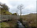
Path and boardwalk
by Lairich Rig geograph for square NS3382 Compare NS3382 : Path and signpost, a view in the opposite direction, where the same boardwalk... (more)
|
|
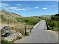
Boardwalk at Newburgh Beach
by Oliver Dixon geograph for square NK0024 This boardwalk does not actually lead to the beach as one might expect, but to a... (more)
|
|
Boardwalk in the woods at Bluestone
by TCExplorer geograph for square SN0613 This boardwalk helps pedestrians down the steep ravine to Camp Smokeys
|
|
Boardwalk near the coast
by Oliver Dixon geograph for square SZ1590 A boardwalk has been laid down to protect the coastal zone from the extensive... (more)
|
|
Boardwalk in Balmedie Country Park
by Oliver Dixon geograph for square NJ9717 It may not be immediately obvious but this boardwalk which runs along the... (more)
|
|
Boardwalk through a Nature Reserve
by John P Reeves geograph for square SX9787 This boardwalk runs next to railway and across the Bowling Green Marsh RSPB... (more)
|
|
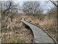
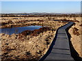
Boardwalk in reedbed at Low Barns Nature Reserve
by Trevor Littlewood geograph for square NZ1631 This stretch of the boardwalk through the reedbed at the reserve has been more... (more)
|
|
View of the boardwalk from the corner
by Philip Halling geograph for square SN6862 Boardwalk protects the bog at Cors Caron from the erosion walkers feet cause and... (more)
|
|
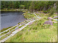
Boardwalk south of Carlingwark Loch
by Oliver Dixon geograph for square NX7660 A boardwalk has been constructed to carry the path from Cuckoo Bridge to Kelton... (more)
|
|
The boardwalk at Linacre Upper Reservoir
by Graham Hogg geograph for square SK3272 Linacre reservoirs became non-operational in 1995 and today theyre managed for... (more)
|
|
On the boardwalk at Upper Linacre Reservoir
by Graham Hogg geograph for square SK3272 The highest of a chain of three reservoirs built between 1855 and 1904 to supply... (more)
|
|
Springwell Lake boardwalk
by Mark Percy geograph for square TQ0392 A newly constructed boardwalk runs along a stretch of the lake's western... (more)
|
|
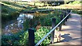
Low Sunshine over the Boardwalk
by John P Reeves geograph for square TQ5940 Low winter sunshine over the boardwalk of the wetlands in Grosvenor Park &... (more)
|
|
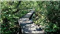
Boardwalk through wetlands in the park
by John P Reeves geograph for square TQ5940 This boardwalk through some pools and reeds in Grosvenor Park & Hibert Woods... (more)
|
|
Boardwalk in reedbed
by Trevor Littlewood geograph for square NZ1631 A stretch of the boardwalk through the reedbed at the Low Barns Nature Reserve.
|
|
Boardwalk repairs, Cors Caron
by Rudi Winter geograph for square SN6862 The boardwalk circuit in Cors Caron is being repaired. In August 2018, a short... (more)
|
|
Boardwalk on the loop path, Cors Caron
by Rudi Winter geograph for square SN6862 The boardwalk gives easy access to the heart of the raised bog. The branching... (more)
|
|
Boardwalk on the Lon Las Cefni
by Oliver Dixon geograph for square SH4476 At this point, the Lon Las Cefni cycle route (part of National Cycle Network... (more)
|
|
Destroyed boardwalk leading to Ross Walk in Belgrave
by Mat Fascione geograph for square SK5906 This boardwalk used to run between Ross Walk and the Swans Nest Footbridge, it... (more)
|
|
Destroyed boardwalk near Belgrave Lock no 44
by Mat Fascione geograph for square SK5906 This boardwalk used to run between Ross Walk and the Swans Nest Footbridge... (more)
|
|
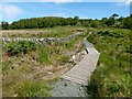
Boardwalk round Lough Carrun
by Oliver Dixon geograph for square Q5907 Lough in the heart of the Glanteenassig Forest Park, spectacularly located... (more)
Tags:
Boardwalk
subject:Boardwalk
Forest ParkX
top:Lakes, Wetland, BogX
LoughX
top:PathsX
top:Sport, LeisureX
|
|
Dungeness: the boardwalk approaches the sea
by Chris Downer geograph for square TR0916 Walking along the boardwalk in the direction shown in TR0916 : Dungeness: boardwalk to the beach, the path... (more)
|
|
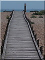
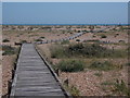
Dungeness: boardwalk to the beach
by Chris Downer geograph for square TR0916 The boardwalk crosses the shingle from the road to the shore, and is certainly... (more)
|
|
Wales Coast Path boardwalk by the River Kenfig/Afon Cynffig (2)
by eswales geograph for square SS7883 A view from the southern end of the boardwalk which crosses a boggy, wooded area... (more)
Tags:
Boardwalk
subject:Boardwalk
top:Lakes, Wetland, BogX
top:PathsX
Wales Coast PathX
long distance path:Wales Coast PathX
top:Woodland, ForestX
|
|
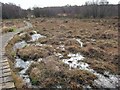
Boggy heathland
by Richard Dorrell geograph for square SX6492 Looking east, the boardwalk provides dry access over a large boggy patch.
|
|
Below Cosdon Hill
by Richard Dorrell geograph for square SX6492 Here, looking west, the boardwalk crosses open and very boggy ground.
|
|
Boardwalk between Rest Bay and Pink Bay
by eswales geograph for square SS7978 This boardwalk lies on the Wales Coast Path and runs along the western boundary... (more)
Tags:
subject:Boardwalk
Boardwalk
top:CoastalX
top:PathsX
Public FootpathX
Sker PointX
long distance path:Wales Coast PathX
Wales Coast PathX
|
|
Boardwalk on the climb up to the Spinc
by Oliver Dixon geograph for square T1095 The Spinc and Glenealo Valley route is a popular 9 km walking route from... (more)
|