Geograph - photograph every grid square
About tags on Geograph
Tags
Geographical Context
Subjects
Types
Other Prefixes
Public Tags
Related Tags
|
Coverage Map
Tag:
Borough·Council·Boundary
Showing images tagged with
Borough Council Boundary
tag.
View all tagged images
-
In Browser
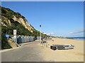
Promenade at the Bournemouth/Poole boundary
by
Malc McDonald
geograph for square
SZ0789
The seafront promenade stretches for around 10 miles along the coastline through... (
more
)
Tags:
Borough Boundary
X
Borough Boundary Sign
X
Borough Council Boundary
subject:
Boundary
X
top:
Boundary, Barrier
X
near:
Bournemouth
X
top:
Coastal
X
type:
Geograph
X
National Cycle Network
X
National Cycle Network Route 2
X
National Cycle Route 2
X
NCN
X
NCN2
X
top:
Paths
X
near:
Poole
X
Promenade
X
national cycle network:
Route 2
X
Sand Beach
X
Sandy Beach
X
Seaside Promenade
X
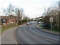
Moor Lane, Chessington
by
Malc McDonald
geograph for square
TQ1963
Moor Lane is a road in Chessington, on the fringe of south west London. Here,... (
more
)
Tags:
Bare Tree
X
Bare Trees
X
Bare Trees in Winter
X
Bare Winter Trees
X
Borough Boundary Sign
X
Borough Council Boundary
subject:
Boundary
X
top:
Boundary, Barrier
X
place:
Chessington
X
boundary:
County
X
County Boundary
X
type:
Geograph
X
top:
Roads, Road Transport
X
place:
South West London
X
top:
Suburb, Urban Fringe
X
Suburban Road
X
county:
Surrey
X
place:
West Ewell
X
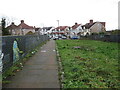
Bridge over a railway near South Harrow
by
Malc McDonald
geograph for square
TQ1485
A bridge carrying a path across a railway line near South Harrow. At the far... (
more
)
Tags:
Borough Boundary
X
Borough Council Boundary
Bridge Over Railway
X
type:
Geograph
X
near:
Harrow
X
boundary:
Local Authority
X
Local Authority Boundary
X
place:
North West London
X
subject:
Path
X
top:
Paths
X
Public Footpath
X
near:
South Harrow
X
top:
Suburb, Urban Fringe
X
Suburban Houses
X
Suburban Housing
X
near:
Sudbury Hill
X
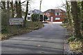
Scott's Grove Road
by
Alan Hunt
geograph for square
SU9660
The sign at the boundary between Woking and Surrey Heath borough councils on... (
more
)
Tags:
Borough Council Boundary
top:
Boundary, Barrier
X
near:
Chobham
X
top:
Roads, Road Transport
X
View more in the Image Search
or
in Browser
View images matching 'Borough Council Boundary' anywhere
in
the tags
Don't click these:
PotMel 1
PotMel 2
☰
Home
View
Search
Marked Images
Maps
Browser
Explore
Showcase
New Images
Collections
Interact
Games
Discussions
Blog
Contributors
Submit
Statistics
Leaderboards
General
FAQ
Help Pages
Sitemap
Contact Us
Support Us
sponsored by
🔍
What to search:
Photos
Enter keywords or a location/postcode to search nearby images
Enter a Grid Reference
Placenames
Collections
Website Pages
Everything
Others:
Advanced Search
|
Image Browser
Or:
Coverage Map
|
Searchable Map
You are not logged in
login
|
register