Geograph - photograph every grid square
About tags on Geograph
Tags
Geographical Context
Subjects
Types
Other Prefixes
Public Tags
Related Tags
|
Coverage Map
Tag:
Brown·Tourist·Sign
Showing images tagged with
Brown Tourist Sign
tag.
View all tagged images
-
In Browser
Search within these images
:
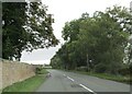
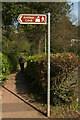
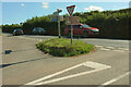
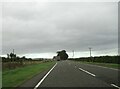
Minor road junction on A698 east of Kelso
by
Martin Dawes
geograph for square
NT7536
The stone wall to the left is the Hendersyde Park Estate. The minor road goes up... (
more
)
Tags:
A698
X
Brown Tourist Signs
X
top:
Country Estates
X
Estate Boundary Wall
X
type:
Geograph
X
Junction of A-Road and Minor Road
X
top:
Lowlands
X
top:
Roads, Road Transport
X
top:
Woodland, Forest
X
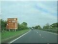
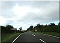
Large brown tourist info sign on A64 Malton bypass
by
Martin Dawes
geograph for square
SE8073
Tags:
road:
A64
X
Brown Tourist Sign
type:
Geograph
X
top:
Lowlands
X
bypass:
Malton
X
top:
Roads, Road Transport
X
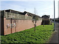
An unusual sign on Feversham Lane
by
Neil Owen
geograph for square
ST4939
It can't be many fish and chip shops that have a brown English tourism sign... (
more
)
Tags:
Brown Tourist Sign
type:
Geograph
X
top:
Roads, Road Transport
X
subject:
Sign
X
top:
Suburb, Urban Fringe
X
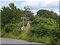
Brown signs
by
Bill Harrison
geograph for square
SH4638
The Llyn Peninsula is full of things to see and do and thoroughly recommended as... (
more
)
Tags:
Brown Tourist Sign
top:
Communications
X
type:
Geograph
X
place:
Llyn Peninsula
X
top:
Roads, Road Transport
X
Rural Road Junction
X
Sign for Anstey's Cove
by
Derek Harper
geograph for square
SX9364
The sandcastle and flag become somewhat misleading symbols in the case of... (
more
)
Tags:
Beach Direction Sign
X
Brown Tourist Sign
type:
Geograph
X
Hedges
X
top:
Lowlands
X
Path
X
top:
Paths
X
Roadside Hedge
X
Roadside Trees
X
top:
Sport, Leisure
X
Walker
X
Junction with Low Lane (caravan route) to Helmsley
by
Martin Dawes
geograph for square
SE4678
From the A19 it is marked on the O/S map as Caravan Route avoiding Sutton Bank
Tags:
Brown Tourist Sign
type:
Geograph
X
Hedgerows and Grass Verges
X
Junction of A-Road and Minor Road
X
top:
Lowlands
X
top:
Roads, Road Transport
X
Roadside Signs
X
Wood
X
top:
Woodland, Forest
X
Sign for the Richard Hillary RAF Memorial on B6460
by
Martin Dawes
geograph for square
NT7345
The Memorial is on the roadside junction leading to the WW2 Charterhouse... (
more
)
Tags:
Brown Tourist Sign
type:
Geograph
X
Junction of A-Road and B-Road
X
top:
Lowlands
X
top:
Roads, Road Transport
X
place:
Scottish Borders
X
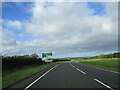
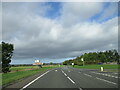
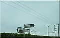
Approaching offset crossroads on A697
by
Martin Dawes
geograph for square
NT7742
Tags:
road:
A697
X
Brown Tourist Sign
Crossroads Sign
X
type:
Geograph
X
Hedgerows and Grass Verges
X
top:
Lowlands
X
Offset Crossroads
X
top:
Roads, Road Transport
X
place:
Scottish Borders
X
Crossroads on a high point 131 Metres
by
Martin Dawes
geograph for square
NT6735
The road to Floors Castle and Kelso is straight on, descending steadily into the... (
more
)
Tags:
Brown Tourist Signs
X
Crossroads B Roads
X
top:
Farm, Fishery, Market Gardening
X
type:
Geograph
X
top:
Lowlands
X
Road Direction Signs
X
top:
Roads, Road Transport
X
North Park Corner
by
Derek Harper
geograph for square
SX7855
The grass island appears in
Link
,... (
more
)
Tags:
A Road (Classified A)
X
Brown Tourist Signs
X
type:
Geograph
X
Give Way Sign
X
Grass Island
X
top:
Lowlands
X
Road Junction
X
top:
Roads, Road Transport
X
Roadside Hedges
X
Signpost
X
By Castle Lodge
by
Derek Harper
geograph for square
SX8361
A sign on the lane to Afton directs visitors to Berry Pomeroy Castle, past the... (
more
)
Tags:
Brown Tourist Sign
type:
Geograph
X
top:
Lowlands
X
top:
Quarrying, Mining
X
Wood
X
top:
Woodland, Forest
X
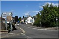
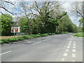
Looking up Trinity Road (the B966), Brechin
by
Bill Harrison
geograph for square
NO5960
The B966 links Brechin with Fordoun and is some 30 km long:... (
more
)
Tags:
road:
B966
X
Brown Tourist Signs
X
top:
City, Town Centre
X
type:
Geograph
X
Road Junction in Town
X
top:
Roads, Road Transport
X
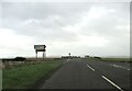
Orange Lane crossroads on A697
by
Martin Dawes
geograph for square
NT7742
A large Agricultural dealership is to the right on Orange Lane B6461
Tags:
road:
A697
X
Agricultural Machinery Dealership
X
Brown Tourist Sign
top:
Business, Retail, Services
X
type:
Geograph
X
top:
Lowlands
X
Offset Crossroads
X
top:
Roads, Road Transport
X
place:
Scottish Borders
X
top:
Woodland, Forest
X
A698 toward Birgham at Highridgehall junction
by
Martin Dawes
geograph for square
NT7637
Turn left for barn, holiday cottages or B & B. The River Tweed is one field... (
more
)
Tags:
A698
X
Brown Tourist Signs
X
top:
Flat Landscapes
X
type:
Geograph
X
Junction of A-Road and Minor Road
X
top:
Roads, Road Transport
X
top:
Village, Rural Settlement
X
Rural junction
by
Bill Harrison
geograph for square
SH4638
Tags:
Brown Tourist Sign
type:
Geograph
X
top:
Lowlands
X
top:
Roads, Road Transport
X
Rural Road Junction
X
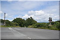
Power lines and signpost
by
Martin Dawes
for square
NU1924
Tags:
Brown Tourist Sign
type:
Close Look
X
top:
Energy Infrastructure
X
top:
Lowlands
X
Overhead Power Lines
X
Road Signpost
X
top:
Roads, Road Transport
X
Junction into Dalby Forest from the Whitby road
by
Martin Dawes
geograph for square
SE8485
Tags:
Brown Tourist Sign
Dalby Forest
X
type:
Geograph
X
top:
Lowlands
X
Road Junction
X
top:
Roads, Road Transport
X
top:
Woodland, Forest
X
View more in the Image Search
or
in Browser
View images matching 'Brown Tourist Sign' anywhere
in
the tags
Don't click these:
PotMel 1
PotMel 2
☰
Home
View
Search
Marked Images
Maps
Browser
Explore
Showcase
New Images
Collections
Interact
Games
Discussions
Blog
Contributors
Submit
Statistics
Leaderboards
General
FAQ
Help Pages
Sitemap
Contact Us
Support Us
sponsored by
🔍
What to search:
Photos
Enter keywords or a location/postcode to search nearby images
Enter a Grid Reference
Placenames
Collections
Website Pages
Everything
Others:
Advanced Search
|
Image Browser
Or:
Coverage Map
|
Searchable Map
You are not logged in
login
|
register