Public Tags
Tag: Burns
Showing latest 50 of 7,602 images tagged with Burns tag.

|
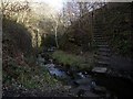
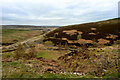
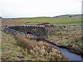
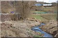
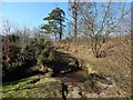
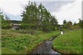
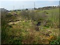
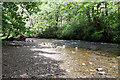
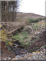
Blaydon Burn
by Andrew Curtis geograph for square NZ1763 The east bank of Blaydon Burn, downstream from the site Masseys Forge, is... (more)
Tags:
BurnX
top:Derelict, DisusedX
former:Industrial SiteX
top:LowlandsX
Retaining WallX
top:Rivers, Streams, DrainageX
|
|
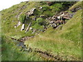
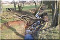
Steps on south bank of Blaydon Burn
by Andrew Curtis geograph for square NZ1763 |
|
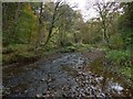
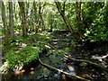
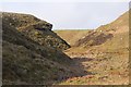
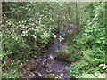
Gruggies Burn
by Lairich Rig geograph for square NS4175 The view is similar to NS4175 : Gruggies Burn, but is from the bed of the burn, and from... (more)
|
|
Path crossing the Bonhill Burn
by Lairich Rig geograph for square NS3979 Just after passing by NS3979 : Bonhill Parish Church, the path crosses above the Bonhill Burn at... (more)
Tags:
Bonhill BurnX
BurnX
river:LevenX
top:PathsX
top:Rivers, Streams, DrainageX
The Pappert BurnX
West Dunbartonshire Core PathX
|
|
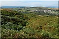
Does Biodiversity Matter?
by Mick Garratt geograph for square SE4799 A moor that is well managed for grouse shooting is likely to have a higher... (more)
|
|
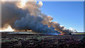
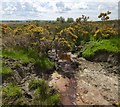
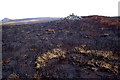
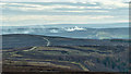
Moor burning, Stanghow Moor
by Mick Garratt geograph for square NZ6514 The Farming Today program on BBC Radio 4 on Wednesday covered moorland... (more)
|
|
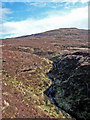
The Craigendoran Burn
by Lairich Rig geograph for square NS3181 As shown on the map, the course of the burn is just to the west of a road. The... (more)
|
|
The Milligs Burn
by Lairich Rig geograph for square NS3084 This part of the burn, though greatly depleted on account of the recent dry... (more)
|
|
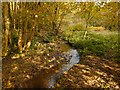
The Carrochan Burn
by Lairich Rig geograph for square NS4081 This is a view downstream. This section of the burn flows immediately to the... (more)
|
|
Hawkwood Burn
by Andy Waddington geograph for square NZ0033 Category: Burn Just before joining Howden Burn, Hawkwood Burn flows under a large embankment... (more)
|
|
Burn flowing past Ravens Craig
by Lairich Rig geograph for square NS2474 The picture was taken from the path beside the Greenock Cut. The burn flows past... (more)
Tags:
BurnX
top:Rivers, Streams, DrainageX
|
|
A burn beside the West Highland Way
by Lairich Rig geograph for square NS5281 The burn is the one whose tree-lined course can be seen in the low ground on the... (more)
Tags:
BurnX
top:Rivers, Streams, DrainageX
|
|
The Fairy Glen
by Lairich Rig geograph for square NS3883 A path leads alongside the Burn of Balloch ... (more)
|

|
Vale of Leven Cemetery: the lower bridge
by Lairich Rig geograph for square NS3879 The bridge leads over a burn. Like NS3879 : Vale of Leven Cemetery: the upper bridge, this bridge is a later addition... (more)
|

|
Vale of Leven Cemetery: the upper bridge
by Lairich Rig geograph for square NS3879 The cemetery, as originally laid out, was set entirely on the northern side of... (more)
|
|
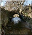
Bridge over unnamed burn
by Richard Dorrell geograph for square NG3653 Category: Burn This burn runs close to and parallel to the Braebost Burn, and both flow under... (more)
|

|
Drynoch Burn
by Richard Dorrell geograph for square NG4032 Category: Burn The line of the A863 follows the valley of the burn, leaving the burn to squeeze... (more)
|
|
Roughting Burn joining Overtoun Burn
by Lairich Rig for square NS4377 Category: Stream Roughting Burn (entering the image at top right) descends the steep-sided valley... (more)
Tags:
BurnX
top:Rivers, Streams, DrainageX
|
|
The Back Burn
by Jim Barton geograph for square NT1756 The burn drains from the moorland south of Carlops to join the Harlawmuir Burn... (more)
Tags:
BurnX
type:GeographX
Grassy Moorland with BrackenX
top:MoorlandX
top:Rivers, Streams, DrainageX
|
|
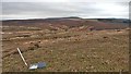
Bronze Age Round Cairn on a scorched moor
by Mick Garratt geograph for square NZ5912 Sunday before last (18th) was a glorious November day. Blue skies, little wind... (more)
|
|
Spittal Burn below the farm
by Jim Barton geograph for square NT0638 The burn alongside the minor road near Spittal Farm. Note the Scottish Borders... (more)
Tags:
top:Boundary, BarrierX
BurnX
FarmlandX
type:GeographX
Regional BoundaryX
top:Rivers, Streams, DrainageX
|
|
Burn below West Mains
by Jim Barton geograph for square NT1554 The burn drains fields at the foot of Mount Maw, here heading E then NE to join... (more)
|
|
West Highland Way and the Camphill Burn
by Lairich Rig geograph for square NS5280 The 1:50000 map shows the burn flowing alongside the path, which is also part of... (more)
Tags:
BurnX
long distance path:John Muir WayX
top:PathsX
top:Rivers, Streams, DrainageX
long distance footpath:West Highland WayX
|
|
Confluence of burns
by Lairich Rig geograph for square NS5184 See NS5184 : Track to sewage works, where this area appears on the right. The present picture shows... (more)
|
|
Path crossing burn
by Lairich Rig geograph for square NS4180 The crossing is just a few metres uphill of a NS4180 : Gate and stile, which lie ahead on... (more)
|

|
Bridge over the Cameron Burn: detail
by Lairich Rig geograph for square NS4583 In this view from the southern parapet, the Cameron Burn is shown flowing... (more)
|

|
The Milligs Burn
by Lairich Rig geograph for square NS2982 The photograph shows the burn flowing through NS2982 : Hermitage Park, just upstream of the... (more)
|
|
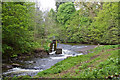
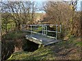
Weir On The Turret Burn
by Martin Addison geograph for square NN8522 Located at the northern end of MacRosty Park, the weir was used to divert some... (more)
|
|
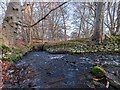
The Udale Burn
by valenta geograph for square NH7164 The burn flows out from the millpond and turns 90 degrees before falling down... (more)
Tags:
type:GeographX
top:Lakes, Wetland, BogX
top:LowlandsX
top:Rivers, Streams, DrainageX
subject:StreamX
The Black IsleX
burn:Udale BurnX
top:Woodland, ForestX
|
|
The Udale Burn
by valenta geograph for square NH7164 The burn where it flows out from a millpond near Udale. The burn flows down to... (more)
Tags:
type:GeographX
top:Lakes, Wetland, BogX
top:LowlandsX
top:Rivers, Streams, DrainageX
subject:StreamX
The Black IsleX
burn:Udale BurnX
top:Woodland, ForestX
|
|
Crosswood Burn and Shear Burn
by Jim Barton geograph for square NT0558 The Shear Burn (L) joins the Crosswood Burn, a tributary of the River Almond.... (more)
Tags:
road:A RoadX
Burns
ConfluenceX
type:GeographX
top:Rivers, Streams, DrainageX
Road Bridges Over BurnsX
top:Roads, Road TransportX
|
|
More moor burning
by Mick Garratt for square NZ6408 Dear Tony Juniper CBE,
Congratulations on your appointment as Chair of... (more)
|
|
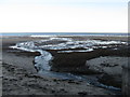
The 'delta' of the Figgate Burn
by M J Richardson geograph for square NT3074 The burn flows into the Firth of Forth at Portobello. Its source is in the... (more)
Tags:
BurnX
subject:CoastX
top:CoastalX
place:EdinburghX
top:Estuary, MarineX
Figgate BurnX
place:Firth of ForthX
type:GeographX
place:PortobelloX
top:Rivers, Streams, DrainageX
Sea ShoreX
top:Suburb, Urban FringeX
|
|
The Red Burn
by Lairich Rig geograph for square NS3381 A short section of the burn flows just within the corner of the OS grid square.... (more)
|
|
The Cochno Burn
by Lairich Rig geograph for square NS4973 At the tree-lined bend in its course, the Cochno Burn is joined by another burn,... (more)
|
|
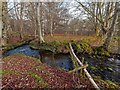
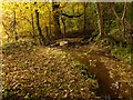
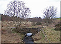
Footbridge over burn
by Lairich Rig geograph for square NS4081 On the far side of the tunnel shown in NS4081 : The Carrochan Burn, the Carrochan Burn is joined... (more)
|
|
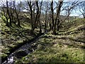
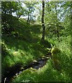
Tributary of the Mill Burn
by Lairich Rig geograph for square NS3879 Not far ahead, the burn disappears from view; that point is the top of a... (more)
Tags:
BurnX
top:Rivers, Streams, DrainageX
|
|
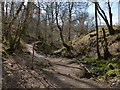
Tributary of the Mill Burn
by Lairich Rig geograph for square NS3879 This is a view upstream. Behind the photographer's position (see... (more)
Tags:
BurnX
top:Rivers, Streams, DrainageX
|

|
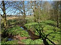
Stakelaw Burn meets the Glensax Burn
by Richard Webb geograph for square NT2633 The confluence where the Stakelaw Burn (left) reaches the Glensax Burn.
Tags:
BurnX
top:Rivers, Streams, DrainageX
|
|
Games Hope Burn
by Walter Baxter geograph for square NT1316 The sheepfold and corrugated iron shed by the Games Hope Burn was viewed from... (more)
|
|
The Catter Burn
by Lairich Rig geograph for square NS4584 The burn closely approaches the road at this point. Not far to the south-west,... (more)
|
|
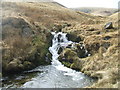
Allt na Faing
by Richard Webb geograph for square NN2218 One of a series of waterfalls on the Allt na Faing (The fank burn, probably... (more)
|
|
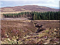
Tributary of Invergeldie Burn
by Mick Garratt geograph for square NN7528 Looking towards Creag Tharsuinn (NN7429) with its muirburn noticeable.
|
|
Turret Burn
by Martin Addison geograph for square NN8521 Beautifully clear water as befits a burn that supplies water to one of Scotlands... (more)
|
|
Glenochar Burn
by Iain Russell geograph for square NS9313 Category: Burn Rising beneath Dun Law the burn flows into Daer Water about a mile from here.
|
|
Cairnsmore Burn
by Iain Russell geograph for square NX4663 Category: Burn Eventually merges with the Palnure Burn and from there into the River Cree.
|
|
Burn towards the forest
by Richard Dorrell geograph for square NG2650 Category: Burn An unnamed burn drains from the southern slope of Beinn Bhreac towards Healaval... (more)
|
|
Boundary burn
by Richard Dorrell geograph for square NG2750 Category: Burn This unnamed burn in Healaval Forest now marks the boundary between standing... (more)
|
|
Burn on the hillside
by Richard Dorrell geograph for square NG2852 Category: Burn The burn is the Allt nam Maighdean, with the summit of Beinn na Boineide in the... (more)
|
|
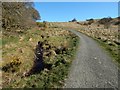
Braebost Burn under the old road
by Richard Dorrell geograph for square NG3653 Category: Burn Viewed from the newer A850, this is the reverse of the image - NG3653 : Braebost Burn under A850 .... (more)
|