|
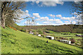
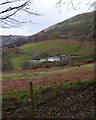
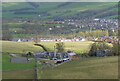
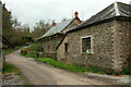
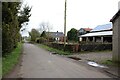
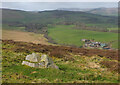
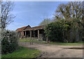
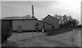
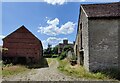
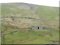
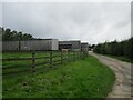
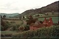
Fron-Gôch farm
by Andy Waddington
geograph for square SH9070
Category: Holiday cottage
The scattered buildings of Fron-Gôch farm lie above a tiny road (single track... (more)
|
|
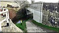
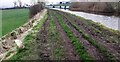
Nant Uchaf
by Andy Waddington
geograph for square SH9268
Category: Public footpath
A rather redundant (and overgrown) footbridge carries the public footpath across... (more)
|
|
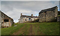
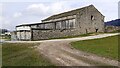
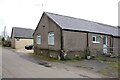
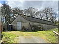
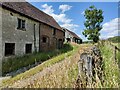
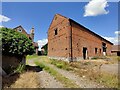
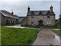
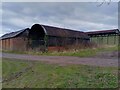
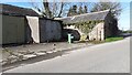
Outbuilding at Glangeirionydd
by Andy Waddington
geograph for square SH7661
Category: Public footpath
This somewhat renovated stone building is passed on the well-marked footpath... (more)
|
|
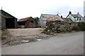
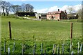
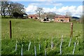
Hawkesley Hill Farm
by Andy Waddington
geograph for square NZ0321
Category: Public footpath
Most of the footpaths in this area seem quite hard to discern on the ground,... (more)
|
|
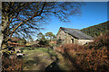
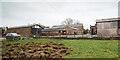
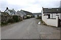
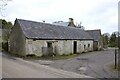
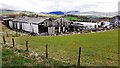
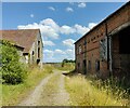
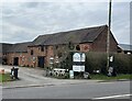
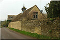
Buildings east of the Grove Hall
by Andy Waddington
geograph for square SJ1069
Category: Farm buildings
A number of farm buildings can be glimpsed from the bridleway in the woods on... (more)
|
|
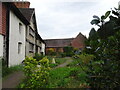
Old Holly Farm
by Andy Waddington
geograph for square SD4949
Category: Farm buildings
Old Holly Farm is a family-run working organic dairy farm, which until recently... (more)
|
|
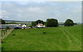
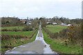
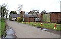
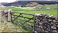
Castle Farm below Fremington Edge
by Andy Waddington
geograph for square NZ0300
Category: Farm buildings
It's nearly always a relief to drop below Fremington Edge to get out of the... (more)
|
|
Hesbert Hall
by Andy Waddington
geograph for square SD7557
Category: Farm buildings
The forest track runs alongside a seriously thistle-infested field at Hesbert... (more)
|
|
Edderston farm and the edge of Peebles
by Jim Barton
for square NT2439
In the sunshine is the new housing development on South Parks.
|
|
New Laithe
by Roger Templeman
geograph for square SD9453
|
|
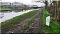
Leeds & Liverpool Canal path passing under A65 at Holme Canal Bridge (#172A)
by Roger Templeman
geograph for square SD9454
|
|
Aldridge Mill Farm
by Derek Harper
geograph for square SS8920
|
|
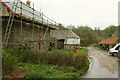
Aldridge Mill Farm
by Derek Harper
geograph for square SS8920
The farmhouse, currently clad in scaffolding for a new roof, is listed and... (more)
|
|
Highflat Farm
by Richard Sutcliffe
geograph for square NS6156
Highflatt Road runs through the farm and turns a sharp right where the arrows... (more)
|
|
Highflat Farm
by Richard Sutcliffe
geograph for square NS6156
|
|
View down Carmunnock Road
by Richard Sutcliffe
for square NS6155
Towards East Kittochside and Dykehead Farms.
|
|
Carmunnock Road
by Richard Sutcliffe
for square NS6155
At East Kittochside Farm.
|
|
East Kittochside Farm
by Richard Sutcliffe
geograph for square NS6156
Home of Kittochside Country Cattery.
|
|
Dykehead Farm
by Richard Sutcliffe
geograph for square NS6156
The buildings are late 18th century and Category B listed... (more)
|
|
Dykehead Farm
by Richard Sutcliffe
geograph for square NS6156
The stone buildings are late 18th century and Category B listed... (more)
|
|
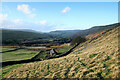
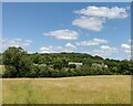
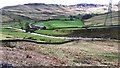
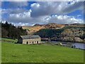
Bellanrigg and the Manor Valley
by Jim Barton
geograph for square NT2338
Fields southwest of the farm occupy land by the Manor Water not far from its... (more)
|

|
Willy Lott's House, Flatford, East Bergholt
by Jo and Steve Turner
geograph for square TM0733
Grade I Listed farmhouse of late 16th, early 17th century. Originally part of... (more)
|
|
Hill Farm, Dumbleton Hill
by Philip Halling
geograph for square SP0034
Hill Farm is situated above the village of Dumbleton in a col between Alderton... (more)
|
|
Hill Farm, Dumbleton Hill
by Philip Halling
geograph for square SP0034
Hill Farm is situated above the village of Dumbleton in a col between Alderton... (more)
|
|
Longham: Sparrow Green Farm
by Michael Garlick
geograph for square TF9514
|
|
Hollands Hall, Brakefield Lane, Brakefield Green, Yaxham
by habiloid
geograph for square TG0209
|
|
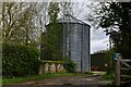
Farm building at Mynderley
by John H Darch
geograph for square SO4497
|
|
Buildings on east side of Old Road at High Thorn
by Luke Shaw
geograph for square SD5298
|
|
Woodhouse Farm near Farley
by Mat Fascione
for square SJ6402
|
|
Orchard Farm, Garvestone
by habiloid
geograph for square TG0208
|
|
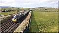
Edinburgh to London Euston train approaching Shap
by Luke Shaw
geograph for square NY5615
The train is an Avanti West Coast pendolino number 390 047
|
|
View of Crookdale Beck and farm buildings from west side of A6
by Roger Templeman
geograph for square NY5504
|

|
Path towards Bradley Farm
by Mat Fascione
geograph for square SJ6301
|
|
Old buildings at Bradley Farm
by Mat Fascione
geograph for square SJ6301
|
|
Old buildings at Bradley Farm
by Mat Fascione
geograph for square SJ6301
The route of the Shropshire Way and the Cross Britain Way.
|
|
Old buildings at Bradley Farm
by Mat Fascione
geograph for square SJ6301
The route of the Shropshire Way and the Cross Britain Way.
|
|
Old barn at Bradley Farm
by Mat Fascione
geograph for square SJ6301
|
|
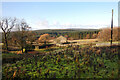
Fields on east side of A6 north of Kidshowe Bridge
by Roger Templeman
geograph for square NY5402
|
|
Cockridge Copy
by Kevin Waterhouse
for square SD9134
Seen across the valley of Thursden Brook from the Slack to Colne road
|
|
Johnsons Cottage, Home Farm, Chirk Castle
by TCExplorer
geograph for square SJ2638
Used as the entrance for National Trust visitors.
|
|
Pear Tree Farm Shop
by John H Darch
geograph for square SJ7764
|
|
Farm View
by Gordon Griffiths
geograph for square SJ9203
The view of Northycote Farm in the Country Park, Wolverhampton.
|
|
Access to farmyard St Giles Farm
by Martin Dawes
geograph for square SE2199
|
|
Farm building below Crookhill Farm
by Graham Hogg
geograph for square SK1886
On the west side of Ladybower Reservoir.
|
|
Leeds and Liverpool Canal heading west towards Low Woodside Farm
by Roger Templeman
geograph for square SE0345
|
|
Ramsworth farm buildings
by Oscar Taylor
geograph for square SU5177
Old barns beside the bridleway.
|
|
Lowerhouse Farm, Eastham
by Martin Tester
geograph for square SO6768
The nearest building is a former malthouse and hop kiln and is GrII listed as... (more)
|
|
Buildings at Hardcake Hall Farm on west side of road
by Roger Templeman
geograph for square NY3051
|
|
The Old Farm, Swinbrook
by Derek Harper
geograph for square SP2812
|
|
Approaching Cowling Bridge on the Leeds & Liverpool Canal 104 miles from Liverpool
by Roger Templeman
geograph for square SE0345
|