|
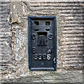
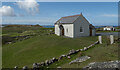
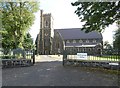
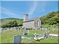
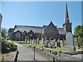
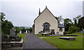
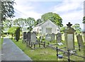
Flush Bracket, Culmore
by Rossographer
for square C4622
Flush bracket bench mark on the southern wall of Culmore Parish Church... (more)
|
|
Bench Mark, Broughshane
by Rossographer
for square D1506
|
|
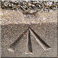
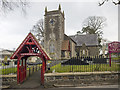
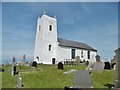
Bench Mark, Killyleagh
by Rossographer
for square J5252
Cut bench mark on the north side of the tower on the parish church in Killyleagh... (more)
|
|
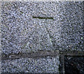
Bench Mark, Ballynahinch
by Rossographer
for square J3652
Rivet bench mark on the south-western tip of Magheradroll Parish Church,... (more)
|
|
Church, Carrickfinn
by Rossographer
geograph for square B7822
Carrickfinn St Andrew (Church of Ireland), located in a beautiful spot near the... (more)
|
|
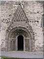
Clonfert Cathedral, west door
by Christopher Hilton
for square M9621
Category: Cathedral
Clonfert is a scatter of a few houses down a no-through-road lane into the... (more)
|
|
Clonfert Cathedral
by Christopher Hilton
geograph for square M9621
Category: Cathedral
Clonfert is a scatter of a few houses down a no-through-road lane into the... (more)
|
|
St. Patrick's Church (Church of Ireland), Harbour Road, Bunbeg, Co. Donegal
by P L Chadwick
geograph for square B8023
St. Patrick's Church is part of the Church of Ireland, which is a... (more)
|
|
St Patrick's Church of Ireland
by Gerald England
geograph for square D1003
Ballymena Parish Church was consecrated in 1855. It was totally destroyed by a... (more)
|
|
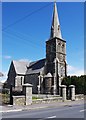
Donegal Town Church
by Gerald England
geograph for square G9278
Originally designed and constructed by local man William Graham who also built... (more)
|
|
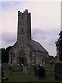
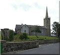
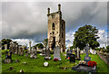
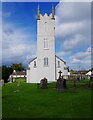
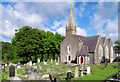
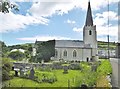
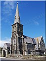
St Patrick's parish church, Broughshane
by Rossographer
geograph for square D1506
Church of Ireland parish church on the Rathkeel Road, Broughshane. It was built... (more)
|
|
Christ Church (1), Church Road, Tramore, Co. Waterford
by P L Chadwick
geograph for square S5701
Tramore's Church of Ireland (Anglican) church is in the Gothic Revival... (more)
|
|
St. Paul's Church and the N63 road, Killashee, Co. Longford
by P L Chadwick
geograph for square N0770
St. Paul's Church is the local Church of Ireland church. It was rebuilt in... (more)
|
|
Ballygawley Parish Church
by Rossographer
geograph for square H6257
Ballygawley Parish Church of Ireland.
|
|
Church of Ireland church (1), Borrisokane, Co. Tipperary
by P L Chadwick
geograph for square R9193
Located in the town centre, at the junction of Nenagh Road (N52) and Church Road... (more)
|
|
St Anne's Church, Toem, Co. Tipperary
by Mike Searle
geograph for square R8647
A ruined Church of Ireland church, built c.1820. The nave has been demolished... (more)
|
|
Rathlin Island, St. Thomas'
by Mike Faherty
geograph for square D1451
Parish church (Church of Ireland) built on an ancient site overlooking Church... (more)
|
|
Church of Ireland church (3), Borrisokane, Co. Tipperary
by P L Chadwick
geograph for square R9193
The church has an impressive three stage bell tower, seen in this view.... (more)
|
|
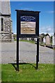
Church of Ireland church (2) - signboard, Borrisokane, Co. Tipperary
by P L Chadwick
for square R9193
|
|
Church of the Transfiguration Sneem
by Martin Dawes
geograph for square V6966
Church of Ireland
|
|
Carrickfergus, St. Thomas'
by Mike Faherty
geograph for square J4187
Church of Ireland church on Lancasterian Street. Dating from 1178, rebuilt in... (more)
|
|
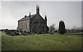
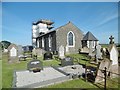
Magheradroll Parish Church, Ballynahinch
by Rossographer
geograph for square J3652
The already much photographed Link... ( more) |
|
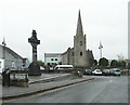
Memorial cross and Church of Ireland Church, Letterkenny
by Humphrey Bolton
geograph for square C1611
|
|
St Columba's Church, Durrow, Co. Offaly
by Mike Searle
geograph for square N3230
The church dates from c.1733, but was largely rebuilt in 1802. Its most notable... (more)
|
|
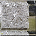
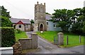
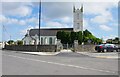
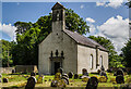
Garrison Parish Church
by Rossographer
geograph for square G9451
Parish church in the village of Garrison. There is a flush bracket bench mark on... (more)
|
|
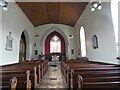
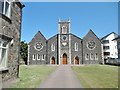
Inside Donegal Town Church
by Gerald England
for square G9278
|
|
Glenarm, St. Patrick's
by Mike Faherty
geograph for square D3115
Parish church dating from the 1760s, built on the site of an earlier friary;... (more)
|
|
Dunseverick Parish Church
by Mike Faherty
geograph for square C9742
Actually on the outskirts of Lisnagunogue, on A2 (Whitepark Road). Built in... (more)
|
|
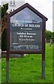
Christ Church (3) - Information board, Church Road, Tramore, Co. Waterford
by P L Chadwick
for square S5700
The board is outside the church, adjacent to the road and the graveyard.... (more)
|
|
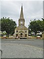
Christ Church (2) & Sea Horse Obelisk, Church Road, Tramore, Co. Waterford
by P L Chadwick
geograph for square S5701
The obelisk to the right of the church marks a burial plot for some of those who... (more)
|
|
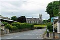
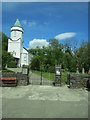
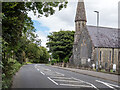
The Culmore Road at Culmore
by Rossographer
geograph for square C4622
The Culmore Road, with Culmore parish church on the right.
|
|
Ballyharry, St. John's
by Mike Faherty
geograph for square J4697
Historic CoI church on Low Road, possibly dating back to 1595.... (more)
|
|
Ballycastle, Holy Trinity
by Mike Faherty
geograph for square D1140
Parish church on the Diamond. Built in 1756 for local land owner Col Hugh Boyd.
|
|
Ballintoy Parish Church
by Mike Faherty
geograph for square D0344
On Harbour Road; dating from 1813:... (more)
|
|
Portrush, Holy Trinity
by Mike Faherty
geograph for square C8540
CoI church on Main Street, dated 1841.... (more)
|