Public Tags
Tag: Cleuch
Showing latest 50 of 83 images tagged with Cleuch tag.
|
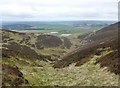
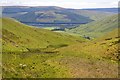
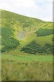
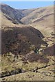
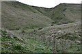
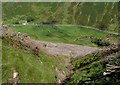
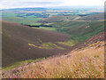
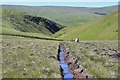
Martingill Cleuch on Tinto
by Alan O'Dowd geograph for square NS9434 Looking down the cleuch towards Lochlyock Reservoir and Cleuch Reservoir
|
|
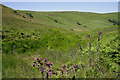
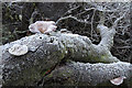
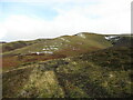
Crock Cleuch
by Walter Baxter geograph for square NT8317 Rough grass, bracken, thistles and a small burn are in this cleuch between... (more)
|
|
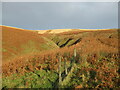
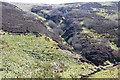
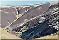
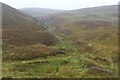
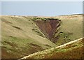
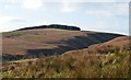
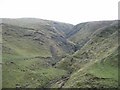
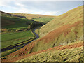
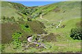
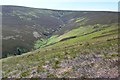
The upper reaches of Brown's Cleuch
by Alan O'Dowd geograph for square NS8116 Brown's Cleuch forms a deep ravine in the side of Craignorth Hill, but the... (more)
|
|
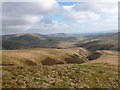
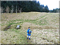
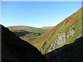
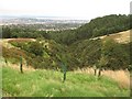
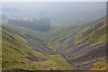
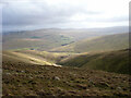
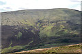
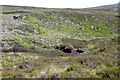
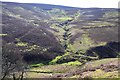
Looking into Lang Cleuch
by Alan O'Dowd geograph for square NS8608 Lang Cleuch is the long gully seen here separating the spurs running south of... (more)
Tags:
Cleuch
type:GeographX
subject:HillsideX
Lowther HillsX
top:MoorlandX
top:Rivers, Streams, DrainageX
Southern UplandsX
top:UplandsX
|
|
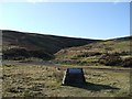
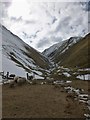
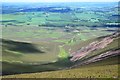
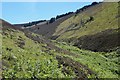
Risping Cleuch
by Iain Russell geograph for square NS9015 Category: Hillside Commemorative stone gives details of the Risping Cleuch Viaduct which spanned... (more)
Tags:
Cleuch
|
|
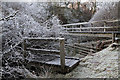
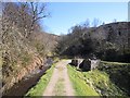
A footbridge at Hawkshaw Cleuch
by Walter Baxter geograph for square NT2726 This bridge on the line of the Southern Upland Way spans the burn in this cleuch... (more)
|
|
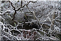
A fallen tree at Hawkshaw Cleuch
by Walter Baxter geograph for square NT2726 This tree has collapsed on to a footbridge over the cleuch on the line of the... (more)
|
|
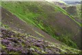
Black Cleuch
by Walter Baxter geograph for square NS8905 Some sheep are grazing near the head of this cleuch on the east side of Black Hill.
|
|
How Cleuch
by Walter Baxter for square NT2223 This telephoto shot towards How Cleuch on Broomy Law was taken from Syart Rig.
|
|
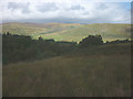
Upper end of How Cleuch
by Jim Barton geograph for square NT2224 A cleuch to the east of the col between Broomy Law and Deer Law. St Mary's... (more)
Tags:
Cleuch
type:GeographX
Grassy Moorland with RushesX
Hill SheepX
top:Lakes, Wetland, BogX
LochX
top:MoorlandX
|
|
At the head of Thorny Cleuch
by Karl and Ali geograph for square NT2722 Descending from Altrieve Rig into the head of the cleuch. A small flock of sheep... (more)
|
|
Cleuch by Ladyside Burn
by Jim Barton geograph for square NT3648 A good example of a cleuch - a steep-sided valley on a hillside. This one has no... (more)
|
|
Brown's Cleuch
by Richard Webb geograph for square NS8016 Steep cleuchs are a feature of the Crawick Water.
|
|
Gill Cleuch
by Jim Barton geograph for square NT3546 The S arm of the deeply cut cleuch on the steep sides of Eastside Heights. After... (more)
|
|
Falla Cleuch
by Oliver Dixon geograph for square NT4819 The path forms part of the Border Abbeys Way, a circular long-distance walking... (more)
|
|
The foot of Capel Cleuch
by Alan O'Dowd geograph for square NS8906 Looking up the steep cleuch between Capel Hill and Black Hill.
|
|
Boar Cleuch
by Jim Barton geograph for square NT2124 'Cleuch' is generally a steep-sided side valley, and a common word in... (more)
|
|
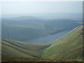
View from Talla Cleuch Head
by Iain Russell geograph for square NT1321 View from near the summit of the hill down to Talla Cleuch and Talla Reservoir.
|
|
Brown's Cleuch
by Alan O'Dowd geograph for square NS8016 Brown's Cleuch is a deep, steep-sided ravine on Craignorth Hill, a striking... (more)
|
|
Cleuch on Wether Law
by Jim Barton geograph for square NT1458 A cleuch or small valley on the E side of Wether Law, not named on the 1:25,000 map.
|
|
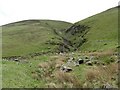
Sheepfold at the foot of Gill Cleuch
by M J Richardson geograph for square NT3446 With a spur of Dewar Hill on the north side of the cleugh [spelling varies on... (more)
Tags:
top:Air, Sky, WeatherX
Cleuch
near:DewarX
top:Farm, Fishery, Market GardeningX
top:GrasslandX
subject:LandscapeX
top:Rivers, Streams, DrainageX
Rough GrazingX
place:Scottish BordersX
Sheep PensX
Snow SceneX
top:UplandsX
|
|
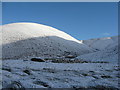
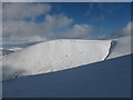
Nickies Knowe in snow
by Alan O'Dowd for square NT1618 Looking from the slope below Molls Cleuch Dod. There are some big convex... (more)
|
|
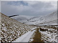
Path through Key Cleuch
by Alan O'Dowd geograph for square NT0029 A narrow valley between Lamington Hill and Broad Hill, through which Cow Gill... (more)
Tags:
Cleuch
CleughX
top:PathsX
top:Rivers, Streams, DrainageX
SnowX
Snowy HillsX
Southern UplandsX
top:UplandsX
|
|
Strang Cleuch, Moffat Dale
by M J Richardson geograph for square NT1914 Category: Clough, cleuch or cleugh |
|
Yearning Cleuch
by Walter Baxter for square NT8718 This gully at Score Head was viewed from a track below Fundhope Rig.
|
|
Cleugh, Dean Burn
by Richard Webb for square NT2167 Category: Clough, cleuch or cleugh A steep craggy gorge in the Pentland Hills, which is a well known pain to... (more)
Tags:
Cleuch
top:Woodland, ForestX
|
|
Above Thorny Cleuch
by Karl and Ali geograph for square NT2723 The stream is cutting down towards Yarrow Water in the sunlit valley ahead.
|
|
Cappercleuch Sike
by Walter Baxter geograph for square NT4233 A small burn runs down this cleuch in Williamhope.
|
|
Cleuch, Greenside Law
by Jim Barton geograph for square NT1925 A small steep side valley off Manor Head.
|
|
Burn on Little King Seat
by Jim Barton for square NT1252 A deep cleuch in shadow on an unnamed burn on the N side of Kings Seat.
|
|
Valley below Skirtle Craig
by Jim Barton geograph for square NT0713 The steep valley or cleuch between Great Hill (R) and Chalk Rig Edge (L).
|
|
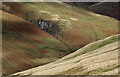
Maurice's Cleuch, Tinto
by Jim Barton geograph for square NS9535 A steep-sided valley on the N side of the hill. The more distant ridge partly... (more)
|
|
Birny Cleuch
by Walter Baxter geograph for square NT2116 This is a view down the north side of Herman Law to the A708 at Kerrcleuch. A... (more)
|
|
The Cut meets the Hole of Spango
by Richard Webb geograph for square NS2373 The Greenock Cut makes a tight turn as it crosses the upper reaches of a deep... (more)
|
|
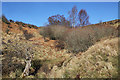
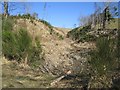
Nars Plantation
by Richard Webb geograph for square NT4429 A wooded cleuch has been recently replanted.
|
|
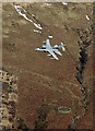
A low flying Tornado at Kerrcleuch
by Walter Baxter for square NT2017 This RAF Tornado GR4 was viewed from Herman Law in mid-February. Little Kerr... (more)
|
|
A fallen tree at Hawkshaw Cleuch
by Walter Baxter for square NT2726 For a view of the tree before it collapsed, see NT2726 : Southern Upland Way Footbridge on the Hawkshaw Cleuch.
|
|
Head of the Wolf Glen
by Richard Webb geograph for square NT4132 A tree has managed to get established on a steep slope of a cleuch. Hazards... (more)
|
|
Whitelaw Cleuch
by Richard Webb geograph for square NT3655 Category: Gully Narrow ravine in the side of Hunt Law.
|
|
View down Rae Cleuch
by Alan O'Dowd geograph for square NS9314 A view with the Daer Reservoir in the distance, beyond some of the many turbines... (more)
Tags:
Cleuch
Clyde Wind FarmX
top:Energy InfrastructureX
type:GeographX
subject:HillsideX
top:MoorlandX
top:Rivers, Streams, DrainageX
Southern UplandsX
top:UplandsX
Wind FarmX
|
|
Across Black Cleuch
by Jim Barton geograph for square NT2745 Looking across the steep-sided valley of the Black Burn from the west side of Cardon Law.
|
|
Trahenna Hill
by Alan O'Dowd geograph for square NT1237 A view across the Earn Cleuch, the upper reaches of which can be seen on the... (more)
|
|
Steep slopes of Craignorth Hill above the Crawick Water
by Alan O'Dowd geograph for square NS8016 A view into the valley of this tributary of the River Nith from the steep... (more)
Tags:
Cleuch
river:Crawick WaterX
type:GeographX
subject:HillsideX
top:MoorlandX
top:Rivers, Streams, DrainageX
Southern UplandsX
top:UplandsX
|
|
Cowie Cleuch, Dollar Law
by Jim Barton for square NT1728 A burn on the north side of Dollar Law descending almost straight for about... (more)
Tags:
BurnX
Cleuch
type:Cross GridX
Grass and Heather MoorlandX
top:MoorlandX
top:Rivers, Streams, DrainageX
top:UplandsX
|
|
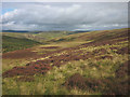
Drainage ditch and sheep, Foulbrig
by Jim Barton geograph for square NT2026 Looking towards Bitch Cleuch which drops steeply to the head of the Manor Valley.
Tags:
Boggy GroundX
Cleuch
Cotton GrassX
Drainage DitchX
type:GeographX
Hill SheepX
top:MoorlandX
top:Rivers, Streams, DrainageX
top:UplandsX
|
|
Boar Cleuch
by Jim Barton geograph for square NT2124 A small steep-sided valley off Glen Gaber. Compare with NT2124 : Boar Cleuch taken in... (more)
Tags:
BrackenX
Cleuch
type:GeographX
Grass and Heather MoorlandX
top:MoorlandX
top:Rivers, Streams, DrainageX
Tree PlantingX
top:UplandsX
top:Woodland, ForestX
|
|
Head of a moorland cleuch below Craigengar
by Jim Barton geograph for square NT0954 The head of a steepening narrow valley on the eastern hillside between... (more)
Tags:
Cleuch
type:GeographX
Heather and Grass MoorlandX
top:MoorlandX
Peat HagsX
top:Rivers, Streams, DrainageX
Rock OutcropX
top:UplandsX
|
|
Earn Cleuch, Glenrath Hope
by Jim Barton geograph for square NT2132 A steep-sided valley between Horse Hope Rig and Hogs Knowe.
|
|
Black Cleuch
by Jim Barton geograph for square NT2230 The wide open spaces of the heather moors between Peebles and St Mary's Loch.
|
|
Cleuch on Kirkhope Law
by Jim Barton geograph for square NT2735 A typical stream gully on the hillside above Glen Sax.
|