Public Tags
Tag: Closed·Railway·Station
Showing latest 50 of 75 images tagged with Closed Railway Station tag.
|
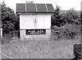
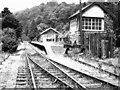
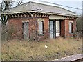
Old signal cabin at Mogeely station
by Albert Bridge geograph for square W9675 The closed, boarded up but not vandalised signal cabin beside the level crossing... (more)
|
|
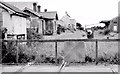
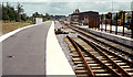
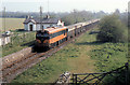
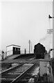
Closed railway station at Mogeely
by Albert Bridge geograph for square W9675 See W9675 : Mogeely railway station (April 1977). 14 years later (ten years after the last beet... (more)
|
|
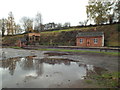
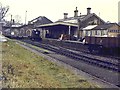
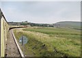
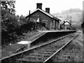
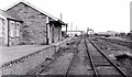
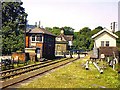
Severn Valley Railway - Eardington Station
by Chris Hodrien geograph for square SO7289 This station was opened in 1868 to serve the Eardington Upper and Lower Forges.... (more)
Tags:
Closed Railway Station
place:EardingtonX
type:GeographX
Preserved Railway StationX
subject:Railway StationX
top:RailwaysX
railway:Severn Valley RailwayX
|
|
Bleach Green station, Whiteabbey
by Albert Bridge geograph for square J3583 The 09.40 Larne Harbour Belfast York Road (703,723,73) passing the closed... (more)
|
|
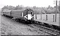
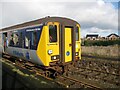
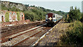
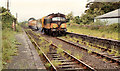
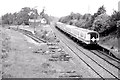
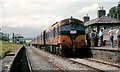
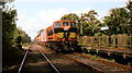
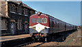
Train at Crumlin Station
by Adrian Taylor geograph for square J1576 450 Class diesel multiple unit number 8785 on a special train at Crumlin... (more)
Tags:
450 ClassX
train:Class 450X
Closed Railway Station
Closed StationX
place:CrumlinX
Crumlin (Co Antrim)X
Crumlin Railway StationX
top:Derelict, DisusedX
Diesel Multiple UnitX
Diesel TrainX
type:GeographX
NIR 450 ClassX
subject:Railway TrainX
top:RailwaysX
|
|
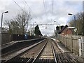
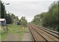
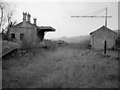
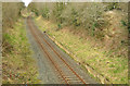
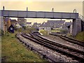
Scotby railway station (site), Cumbria
by Nigel Thompson geograph for square NY4355 Opened in 1836 by the Newcastle and Carlisle Railway, this station closed in... (more)
|
|
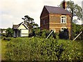
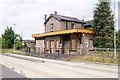
Site of Barlaston railway station
by Jonathan Hutchins geograph for square SJ8838 The station was temporarily closed for WCML modernisation in 2004 and never... (more)
Tags:
place:BarlastonX
Closed Railway Station
type:GeographX
subject:Railway StationX
disused:Railway StationX
former:Railway StationX
Railway Station (Disused)X
Railway Station (Site Of)X
top:RailwaysX
top:Village, Rural SettlementX
|
|
Haddiscoe (low level) railway station (site), Norfolk
by Nigel Thompson geograph for square TM4598 Opened in 1847 by the Norfolk Railway on the line from Norwich to Lowestoft,... (more)
|
|
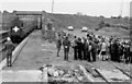
Construction work, Athlone station
by Albert Bridge geograph for square N0441 The new platform and track at the GS&WR station before re-opening as... (more)
|
|
Goraghwood station near Newry
by Albert Bridge geograph for square J0631 Category: Railway station (closed) Goraghwood was the junction where the GNR(I) line to Newry and Warrenpoint left... (more)
|
|
Ballyglunin railway station, County Galway
by Nigel Thompson geograph for square M4742 Opened in 1860 by the Waterford Limerick & Western Railway on the line from... (more)
|
|
Tavistock South station
by Richard Green geograph for square SX4874 The closed Tavistock South (GWR) station. It was originally built as the... (more)
|
|
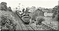
Weed-spraying train, Doagh station
by Albert Bridge geograph for square J2787 CIE locomotive no 206 heads the weed-spraying train past the closed Doagh... (more)
|
|
Beauparc station
by Albert Bridge geograph for square N9471 Category: Railway station (closed) This should have been a Kingscourt Drogheda goods conveying gypsum from the... (more)
|
|
Site of the former Maudland Bridge railway station
by Adam C Snape geograph for square SD5329 Nothing now remains of the former Maudland Bridge railway station which used to... (more)
Tags:
Canal DisusedX
top:CanalsX
Closed Railway Station
top:Derelict, DisusedX
Disused RailwayX
Lancaster CanalX
Maudland BankX
Maudland BridgeX
MaudlandsX
place:PrestonX
subject:RailwayX
top:RailwaysX
|
|
Former Knockmore station, Lisburn (2013)
by Albert Bridge for square J2564 See J2564 : Former Knockmore station, Lisburn (2) (March 2011). The skeleton of a shelter, on an overgrown... (more)
|
|
The closed GWR station at Launceston
by Richard Green geograph for square SX3285 The former GWR station at Launceston, originally built as the terminus of the... (more)
|
|
Former railway station, Donaghadee (1979)
by Albert Bridge geograph for square J5979 See J5979 : Site of Donaghadee station (July 2006). The remains of Donaghadee station 29 years after... (more)
Tags:
top:City, Town CentreX
Closed Railway Station
top:Derelict, DisusedX
DonaghadeeX
former:Railway StationX
top:RailwaysX
|
|
Passengers and train, Tanderagee station (1980)
by Albert Bridge geograph for square J0547 Tanderagee station (using the spelling in Irish Railway Today - 1967) closed... (more)
|
|
Former Neill's Hill station, Belfast (4)
by Albert Bridge for square J3773 See J3873 : Former Neill's Hill level crossing, Belfast. The former Neills Hill station is still there. It (and the... (more)
|

|
Ardee railway station (1)
by Albert Bridge geograph for square N9690 See N9690 : Old railway at Ardee. Ardee station, almost eight years after closure, with the... (more)
|

|
Shotley Bridge Station (as was)
by Oliver Dixon geograph for square NZ1053 Shotley Bridge Station on the Derwent Valley line opened in 1867, closed in... (more)
Tags:
Car ParkX
Closed Railway Station
type:GeographX
top:Housing, DwellingsX
National Cycle NetworkX
top:PathsX
Railway CottagesX
Railway PathX
subject:Railway StationX
top:RailwaysX
top:Roads, Road TransportX
|
|
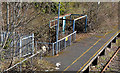
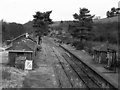
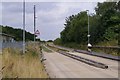
Cwmbargoed Station platform
by Adrian Taylor geograph for square SO0806 The low bank to the right of the sign is all that remains of one of the... (more)
Tags:
Cable DuctX
Closed Railway Station
Derelict Railway Station PlatformX
Excursion TrainX
type:GeographX
top:Historic Sites and ArtefactsX
top:MoorlandX
Old StationX
Opencast Coal MineX
top:Quarrying, MiningX
RailtourX
subject:Railway StationX
top:RailwaysX
SignX
Station PlatformX
TrainX
top:UplandsX
|
|
Train, Dromin near Dunleer (July 1982)
by Albert Bridge geograph for square O0390 Back in the 1980s the name Enterprise was used solely for the cross-Border... (more)
|
|
Steam train, Templepatrick (September 1983)
by Albert Bridge geograph for square J2385 Steam locomotive no 171 Slieve Gullion... (more)
|
|
Lowesby station
by Richard Green geograph for square SK7306 The remains of the main station buildings at Lowesby. The station closed in... (more)
Tags:
Closed Railway LineX
Closed Railway Station
top:Derelict, DisusedX
top:LowlandsX
top:RailwaysX
top:Village, Rural SettlementX
|

|
Lowesby station, east end
by Richard Green geograph for square SK7306 The remains of Lowesby station, looking west. The station closed in 1953, with... (more)
Tags:
Closed Railway LineX
Closed Railway Station
top:Derelict, DisusedX
top:LowlandsX
top:RailwaysX
top:Village, Rural SettlementX
|
|
Redbrook-on-Wye railway station from the south
by Richard Green geograph for square SO5309 Redbrook station on the Wye Valley line opened in 1876 and closed to passengers... (more)
|
|
Redbrook-on-Wye railway station from North
by Richard Green geograph for square SO5310 Redbrook station on the Wye Valley line opened in 1876 and closed to passengers... (more)
|
|
Christow railway station (view North)
by Richard Green geograph for square SX8386 The Teign Valley line on which this station was situated lost its passenger... (more)
Tags:
Closed Railway Station
Goods LineX
top:GrasslandX
top:LowlandsX
top:Quarrying, MiningX
top:RailwaysX
top:Village, Rural SettlementX
Water CraneX
|
|
Bridport East Street station
by Richard Green geograph for square SY4792 The station had been closed to passengers since 1930, but goods traffic on the... (more)
Tags:
top:City, Town CentreX
Closed Railway LineX
Closed Railway Station
top:LowlandsX
top:RailwaysX
top:Rivers, Streams, DrainageX
|
|
Tara Mines train, Duleek
by Albert Bridge geograph for square O0470 CIE locomotive 019 passing the closed station at Duleek (1850/1958) with a train... (more)
|
|
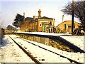
Down platform building, Widmerpool station
by Richard Green geograph for square SK6429 The sadly derelict down platform building of Widmerpool station. This station... (more)
|
|
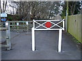
A railway shape
by Neil Owen geograph for square ST4157 The traditional red circle found on older railway property remains as a nod to... (more)
Tags:
Closed Railway Station
GateX
type:GeographX
subject:Railway StationX
top:RailwaysX
top:Village, Rural SettlementX
|
|
Kilmacthomas railway station (1982)
by Albert Bridge geograph for square S3906 An Irish Railway Record Society railtour calling at Kilmacthomas station on the... (more)
|
|
Weed-spraying train,Templepatrick
by Albert Bridge geograph for square J2385 The CIE weed-spraying train, hauled by 169S, approaching the closed station at... (more)
|
|
Ardee station (1976)
by Albert Bridge geograph for square N9690 Ardee station some eleven months after complete closure. The goods shed is on... (more)
|
|
Siding, Tanderagee station
by Albert Bridge geograph for square J0547 Although closed Tanderagee station had a temporary siding, on the down side, to... (more)
|
|
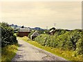
The approach to Lowesby station
by Richard Green geograph for square SK7306 The approach road to Lowesby station, closed in 1953.
Tags:
Closed Railway LineX
Closed Railway Station
top:Derelict, DisusedX
top:LowlandsX
top:RailwaysX
top:Village, Rural SettlementX
|
|
Speech House Road station
by Richard Green geograph for square SO6111 Speech House Road station was the end of the goods line from Lydney (the former... (more)
Tags:
Buffer StopX
Closed Railway Station
top:LowlandsX
top:RailwaysX
Signal BoxX
top:Village, Rural SettlementX
top:Woodland, ForestX
|
|
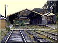
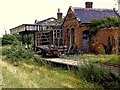
Portesham station and goods shed
by Richard Green geograph for square SY6085 Portesham station and goods shed 10 years after closure. The branch from Upwey... (more)
|
|
Llanmorlais station after closure
by Richard Green geograph for square SS5394 The branch to Llanmorlais from Gowerton South closed to passengers in January... (more)
Tags:
Closed Railway LineX
Closed Railway Station
top:CoastalX
top:GrasslandX
top:RailwaysX
top:Village, Rural SettlementX
|
|
DE set, Cromore station
by Albert Bridge geograph for square C8337 A five-car DE set (75,721,724,728,77) bouncing its way past the closed and... (more)
|
|
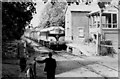
Waiting for signals, Vulcan Halt 1966
by Alan Murray-Rust geograph for square SJ5894 The station was a very basic structure, built to serve the adjacent Vulcan... (more)
|
|
Mossley station, Newtownabbey (remains) March 2014
by Albert Bridge geograph for square J3284 See J3284 : Mossley Station Platform (June 2005). The staggered up platform at the old Mossley... (more)
|
|
Once a proud railway station
by Mr Ignavy geograph for square TL4462 See TL4462 : Histon station (disused) for a view of the closed station before the guided busway was... (more)
|
|
Note the former station platform
by Mr Ignavy geograph for square TL4165 It could be done up and act as a refreshment stop for cyclists.
The railway... (more)
Tags:
Closed Railway Station
top:Derelict, DisusedX
cambridge:Guided BuswayX
top:Roads, Road TransportX
|
|
Easton station
by Richard Green geograph for square SY6971 Easton station on Portland. The branch had closed to passengers in 1952, but... (more)
|
|
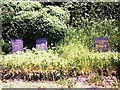
Graves of pets at Talyllyn station
by Richard Green geograph for square SO1027 The slate tablets are inscribed in memory of the dog Prince died 1888 aged 7... (more)
|
|
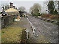
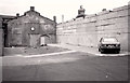
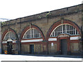
Entrance to former Spa Road station
by Stephen Craven for square TQ3479 This is a historic location, unknown to most travellers on the railway out of... (more)
|