
|
Statue of Captain Cook: Plaque on east face
by Gerald England
for square NZ8911
|

|
New Road Baptist Church
by Gerald England
geograph for square SP5106
A Grade II listed church... (more)
|

|
Killaloe Bridge
by Gerald England
geograph for square R7073
The bridge spans the River Shannon to link Killaloe in County Clare with Ballina... (more)
|
|
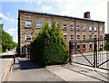
St Helena Mill
by Gerald England
geograph for square SD7109
The grade II listed... (more)
|

|
Dochfour House
by Gerald England
geograph for square NH6039
Dochfour House stands on a rise of ground overlooking Loch Dochfour which... (more)
|

|
Dochfour House
by Gerald England
geograph for square NH6039
Dochfour House stands on a rise of ground overlooking Loch Dochfour which... (more)
|

|
Walkergate House
by Gerald England
geograph for square TA0339
The Grade II listed... (more)
|
|
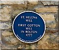
Blue Plaque: St Helena Mill
by Gerald England
for square SD7109
The text reads:
ST. HELENA
MILL
FIRST COTTON
MILL
IN BOLTON
1777... (more)
|

|
##105-109 Oldham Street.
by Gerald England
geograph for square SJ8498
#105 is a Grade II listed building... (more)
|

|
Plaque for Victoria Jacqueline Jane Bell and Alan Crompton
by Gerald England
for square SJ8498
|

|
Old waterbutt
by Stephen Craven
for square SP5206
This large lead waterbutt has a date of 1780 on it.
|

|
Killaloe Bridge
by Gerald England
geograph for square R7073
The bridge spans the River Shannon to link Killaloe in County Clare with... (more)
|

|
Giant Yew Topiary at Powis Castle
by Gerald England
geograph for square SJ2106
Giant yew topiary at Powis Castle was first planted in the 1680s when the... (more)
|

|
Mill Bridge
by Gerald England
geograph for square SD9851
The Grade II listed... (more)
|

|
Stevens No.1 Store, Shardlow
by Alan Murray-Rust
geograph for square SK4430
Originally part of Sutton's Wharf, the only basin wharf constructed on the... (more)
|

|
The George, High Street, Grantham
by Alan Murray-Rust
for square SK9135
See Link Central coaching yard entrance... ( more) |

|
Mill Bridge, Skipton: downstream side
by Stephen Craven
geograph for square SD9851
The bridge carries Raikes Road over the Springs Branch canal, dates from c.1780,... (more)
|

|
Urray church, south side
by Stephen Craven
geograph for square NH5052
'Liturgical' south, actually south-east, not that the Church of... (more)
|

|
Urray Kirk
by Stephen Craven
geograph for square NH5052
One of two churches in the parish of Urray and Kilchrist, the other being in the... (more)
|

|
View upstream from Fall Ing lock
by Stephen Craven
geograph for square SE3419
The lock is the point at which a short section of the Calder & Hebble... (more)
|

|
Footbridge over Fall Ing lock
by Stephen Craven
geograph for square SE3419
The lock is the point at which a short section of the Calder & Hebble... (more)
|

|
59, Scotgate, Stamford
by Alan Murray-Rust
geograph for square TF0207
Part of the old Black Horse Inn. The odd side wall, with datestone of 1780, was... (more)
|

|
Clock Warehouse, Shardlow
by Alan Murray-Rust
geograph for square SK4430
Built 1780, roughly contemporary with the canal, as a warehouse, later a corn... (more)
|
|
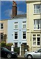
Penrose Cottage, Clifton Down
by Alan Murray-Rust
for square ST5673
One of a pair of houses built c.1780. The 'blue' (actually green)... (more)
|

|
The George, High Street, Grantham
by Alan Murray-Rust
for square SK9135
Datestone, 1780. See Link for location. |
|
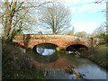
Lewin's Bridge, Twyford
by Alan Murray-Rust
geograph for square SK7210
Built around 1780 by Mr Lewin. A substantial structure for the period on a road... (more)
|

|
Urray church, interior
by Stephen Craven
for square NH5052
|

|
Walkergate House
by Stephen Craven
geograph for square TA0339
These council offices include the present Register Office, replacing the... (more)
|

|
59, Scotgate, Stamford – datestone
by Alan Murray-Rust
for square TF0207
On the North Street face of the building. See... (more)
|
