
|
1823 Taylor Street 1895
by Gerald England
for square SJ9295
|

|
Old Parish Church, Arbroath
by Gerald England
geograph for square NO6441
The church was first erected in around 1590 at the south-west angle of the... (more)
|

|
Strawberry Fields
by Gerald England
geograph for square SJ8990
One of the frogs on the Stockport Frog Trail.
"Strawberry Fields has... (more)
|

|
Great Underbank
by Gerald England
geograph for square SJ8990
On the left is the Grade II listed... (more)
|

|
Underbank Hall
by Gerald England
geograph for square SJ8990
Category: Bank (financial institution)
The Grade II* listed... (more)
|

|
Great Underbank
by Gerald England
geograph for square SJ8990
On the left is the Grade II listed... (more)
|

|
Underbank Hall
by Gerald England
for square SJ8990
|

|
Corner of Hyde Road and Taylor Street
by Gerald England
geograph for square SJ9295
Terraced housing on Hyde Road and Taylor Street. Behind the fencing on the right... (more)
|

|
House on Hints Road
by Alan Murray-Rust
geograph for square SK1804
The sundial on the gable Link is dated 1823,... ( more) |

|
The Star on Carr Lane
by Gerald England
geograph for square TA0928
A public house by the name of White Horse was here by 1823. The present public... (more)
|

|
Three venues on Swan Street
by Gerald England
geograph for square SJ8498
In the middle is the Burton Arms. In the mid-1800s it was known as the John... (more)
|

|
Star Inn
by Gerald England
geograph for square SJ9398
On the corner of Oldham Road and Old Street. It was opened in 1823. Brewers... (more)
|

|
Star Inn
by Gerald England
geograph for square SJ9398
On the corner of Old Street and Oldham Road. It seems to be still open despite a... (more)
|

|
The Beacon Hill
by Gerald England
geograph for square SK6141
Originally called the Black's Head (often signed without an apostrophe)... (more)
|

|
Lincoln Castle: the court house
by Stephen Craven
geograph for square SK9771
This grade II* building (list entry 1388488) dates from 1823 by Sir Robert... (more)
|

|
Fulton's Orrery
by Gerald England
for square NS5666
An orrery is a mechanical model of the Solar System that illustrates or... (more)
|

|
Camellia house roof, Wollaton Hall -2
by Alan Murray-Rust
for square SK5339
See Link for location. The original... ( more) |

|
Camellia house roof, Wollaton Hall -1
by Alan Murray-Rust
for square SK5339
See Link for location. The original... ( more) |

|
Classical decoration
by Alan Murray-Rust
for square SK5339
A corner of the camellia house with Wollaton Hall behind. The camellia house... (more)
|

|
Denver Sluice
by Alan Murray-Rust
for square TF5801
It's not clear how much of the visible masonry dates from John... (more)
|

|
The Bath House, Bath Row, Stamford
by Alan Murray-Rust
geograph for square TF0206
An early baths building, dated 1823 with Gothic detailing, now converted to... (more)
|

|
The Camellia House, Wollaton Hall
by Alan Murray-Rust
for square SK5339
Interior view showing the curved roof over one of the walkways and the date of... (more)
|

|
The old Borough Police Station, Macclesfield
by Alan Murray-Rust
geograph for square SJ9173
Part of the 1870 extensions to the original town hall of 1823 which forms the... (more)
|

|
Maltese cross alongside Tong Church
by Alan Murray-Rust
for square SJ7907
Described as a headstone and dated 1823, it is clearly related to the Durant... (more)
|
|
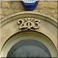
Datestone, 20 Chapel Lane, Barrowden
by Alan Murray-Rust
for square SK9400
The keystone of the central first floor window. See... (more)
|
|
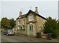
20 Chapel Lane, Barrowden
by Alan Murray-Rust
geograph for square SK9400
The main house is dated 1823 Link the... ( more) |

|
Highfield Farmhouse, Pilton
by Alan Murray-Rust
geograph for square SK9102
Dated 1823 [ Link] although the rear wing may... ( more) |

|
Lenton Lodge pump
by Alan Murray-Rust
geograph for square SK5439
The English Heritage listing dates this as being erected at about the same time... (more)
|

|
Old buildings on Keighley Road at Illingworth
by Stephen Craven
geograph for square SE0728
At the left end of this range is the former bridewell or 'lock-up' of... (more)
|

|
Detail of Celtic cross in Gotts Park
by Stephen Craven
for square SE2634
The inscription reads "These almshouses were erected by Benjamin Gott of... (more)
|

|
Detail of Keighley Road lockup
by Stephen Craven
for square SE0728
An inscribed stone on the former bridewell or 'lock-up' of 1823,... (more)
|

|
Bethel Chapel viewed from near top of Dyserth Falls
by Richard Hoare
geograph for square SJ0579
Dyserth redundant chapel, built in 1823 for the Presbyterians. It is next to the... (more)
|

|
Church of St Mary, Bryanston Square - south side
by Stephen Craven
geograph for square TQ2781
A 'Commissioners church' but with the main entrance and tower... (more)
|

|
Church of St Mary, Bryanston Square - east end
by Stephen Craven
geograph for square TQ2781
A 'Commissioners church' but with the main entrance and tower... (more)
|

|
Toy Box nursery, Market Street, Wakefield
by Stephen Craven
geograph for square SE3320
A Grade II listed former townhouse, built 1823, enlarged c.1870. According to... (more)
|

|
Plaque on the gatepost of Denison Hall
by Stephen Craven
for square SE2934
The plaque gives a brief account of the building of the house for John Wilkinson... (more)
|

|
County Bridge, New Road Mytholmroyd
by Stephen Craven
geograph for square SE0125
The bridge is presumably so called because the county council (West Riding of... (more)
|

|
Underbank Hall Blue Plaque
by Gerald England
for square SJ8990
|

|
The former Oddfellows Hall, Ulverston
by Stephen Craven
geograph for square SD2878
The building is a former Catholic church of 1823, which explains the tower... (more)
|

|
Snowden's Court, Scotgate, Stamford
by Alan Murray-Rust
geograph for square TF0207
Formerly Snowden's Hospital, a set of almshouses, now converted to small... (more)
|

|
The Camellia House, Wollaton Hall
by Alan Murray-Rust
for square SK5339
Detail of a corner of the building, erected in 1823, made of cast iron. Listed... (more)
|

|
Mechanics Institution, Wood Street
by Alan Murray-Rust
geograph for square SE3320
From 'Guide To Selected Historical Buildings In Wakefield' by... (more)
|

|
The old rectory, Sawley
by Alan Murray-Rust
geograph for square SK4731
Built 1823 with later 19th century additions, Listed Grade II for group value.
|

|
11 Hanover Square
by Alan Murray-Rust
geograph for square SE2934
Built c.1823 when Hanover Square was first laid out, it represents the style the... (more)
|

|
Underbank Hall Blue Plaque
by Gerald England
for square SJ8990
|
|
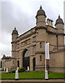
Lenton Lodge
by Alan Murray-Rust
geograph for square SK5439
This is the former gatehouse to Wollaton Hall, facing towards Nottingham.... (more)
|

|
City Life Centre
by Alan Murray-Rust
geograph for square SK3588
Category: Church
An Assemblies of God church in a former nonconformist chapel.
Built in 1823 as... (more)
|

|
Gaunless Bridge, detail
by Alan Murray-Rust
for square NZ2325
|

|
Robert Stephenson by his father’s Gaunless Bridge
by Alan Murray-Rust
for square NZ2325
|

|
Broadside view of the Gaunless Bridge
by Alan Murray-Rust
geograph for square NZ2325
|
