Geograph - photograph every grid square
About tags on Geograph
Tags
Geographical Context
Subjects
Types
Other Prefixes
Public Tags
Related Tags
|
Coverage Map
Tag:
Derelict·Petrol·Station
Showing images tagged with
Derelict Petrol Station
tag.
View all tagged images
-
In Browser
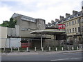
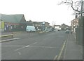
A prime brownfield site
by
HelenK
geograph for square
ST7465
Category: Petrol filling station (disused)
Backing on to the Royal Crescent, this was a petrol station until around the... (
more
)
Tags:
top:
Business, Retail, Services
X
top:
City, Town Centre
X
Derelict Petrol Station
top:
Derelict, Disused
X
top:
Housing, Dwellings
X
former:
Petrol Station
X
top:
Roads, Road Transport
X
Terraced Houses
X
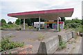
Derelict Petrol Station at Parkeston
by
Glyn Baker
geograph for square
TM2332
Take a look round the back at
TM2332 : Graffiti Wall in Parkeston
Tags:
top:
Coastal
X
Derelict Petrol Station
top:
Derelict, Disused
X
type:
Geograph
X
Graffiti
X
top:
Roads, Road Transport
X
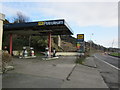
Old Petrol Station
by
Billy McCrorie
geograph for square
NX0668
Pity it's closed it's displaying nice prices.
Tags:
Derelict Petrol Station
top:
Derelict, Disused
X
top:
Roads, Road Transport
X
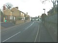
Pattenden Lane, Marden
by
John Baker
geograph for square
TQ7444
Looking towards the derelict petrol station in Church Green.
Tags:
Derelict Petrol Station
top:
Roads, Road Transport
X
top:
Village, Rural Settlement
X
Church Green, Marden
by
John Baker
geograph for square
TQ7444
Showing the derelict petrol station. Ahead, a car is turning into Pattenden Lane.
Tags:
Derelict Petrol Station
top:
Roads, Road Transport
X
top:
Village, Rural Settlement
X
Derelict Garage
by
Mick Garratt
geograph for square
NN5823
Tags:
Derelict
X
Derelict Petrol Station
Derelict Shed
X
top:
Derelict, Disused
X
Dereliction
X
Ruin
X
Graffiti Wall in Parkeston
by
Glyn Baker
for square
TM2332
On the rear of a
TM2332 : Derelict Petrol Station at Parkeston
Tags:
top:
City, Town Centre
X
type:
Close Look
X
Derelict Petrol Station
top:
Derelict, Disused
X
Graffiti
X
Mural
X
View more in the Image Search
or
in Browser
View images matching 'Derelict Petrol Station' anywhere
in
the tags
Don't click these:
PotMel 1
PotMel 2
☰
Home
View
Search
Marked Images
Maps
Browser
Explore
Showcase
New Images
Collections
Interact
Games
Discussions
Blog
Contributors
Submit
Statistics
Leaderboards
General
FAQ
Help Pages
Sitemap
Contact Us
Support Us
sponsored by
🔍
What to search:
Photos
Enter keywords or a location/postcode to search nearby images
Enter a Grid Reference
Placenames
Collections
Website Pages
Everything
Others:
Advanced Search
|
Image Browser
Or:
Coverage Map
|
Searchable Map
You are not logged in
login
|
register