Public Tags
Tag: Deserted
Showing images tagged with Deserted tag.
|
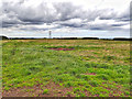
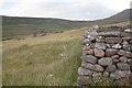
Cold Hesledon Deserted Medieval Village
by Mick Garratt geograph for square NZ4146 Not much to see. Just a field with lots of humps and bumps. Unusually the field... (more)
|
|
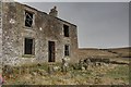
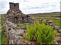
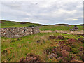
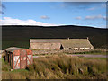
Red Groves House
by Mick Garratt geograph for square NY9129 A deserted farmstead.
|
|
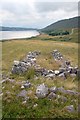
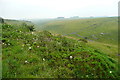
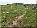
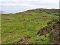
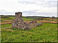
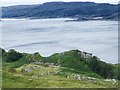
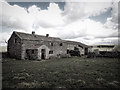
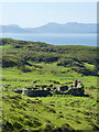
The Deserted Settlement of Kildonan
by Mick Garratt geograph for square NH0890 |
|
The Deserted Settlement of Kildonan
by Mick Garratt geograph for square NH0890 |
|
The Deserted Settlement of Kildonan
by Mick Garratt geograph for square NH0890 |
|
Deserted car wash, Main Road, Magor, Monmouthshire
by Jaggery geograph for square ST4287 A barrier is across the entrance at 11am on Tuesday December 15th 2020.
Tags:
top:Business, Retail, ServicesX
Deserted
Deserted Car WashX
type:GeographX
top:Roads, Road TransportX
top:Village, Rural SettlementX
|
|
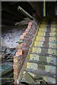
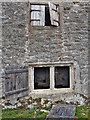
Staircase, Red Groves House
by Mick Garratt for square NY9129 |
|
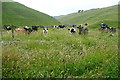
Cattle in Gratton Dale
by Graham Horn geograph for square SK1959 The dale seemed deserted, until I came across these cattle. I was walking down... (more)
|
|
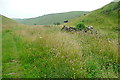
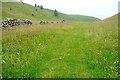
View into Long Dale
by Graham Horn geograph for square SK1860 The bridleway here stays on the high ground to the north of the dale. There are... (more)
|
|
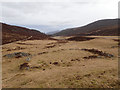
Long Dale
by Graham Horn geograph for square SK1860 The bridleway goes to the left and climbs the hill, form which there are even... (more)
|
|
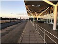
A deserted Stansted Airport
by Richard Humphrey geograph for square TL5523 Taken at 7.37 on a Sunday morning during the COVID-19 pandemic and not a single... (more)
|
|
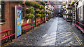
Commercial Court, Belfast
by Rossographer geograph for square J3374 A deserted Commercial Court in Belfast. On a warm Saturday afternoon this would... (more)
Tags:
BarX
BelfastX
place:BelfastX
top:Business, Retail, ServicesX
top:City, Town CentreX
place:Commercial CourtX
CoronavirusX
Coronavirus PandemicX
Deserted
Duke of YorkX
Duke of York Public HouseX
type:GeographX
place:Northern IrelandX
Northern IrelandX
top:PathsX
subject:StreetX
looking towards:The Duke of York Public HouseX
|
|
Reigate Hill car park
by Ian Capper geograph for square TQ2652 Normally a warm and sunny Easter Monday would see the car park at the top of... (more)
Tags:
Car ParkX
CoronavirusX
COVID-19X
Deserted
bank holiday:Easter MondayX
EmptyX
type:GeographX
near:ReigateX
place:Reigate HillX
top:Roads, Road TransportX
|
|
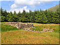
Deserted settlement
by Mick Garratt geograph for square NM6434 By the Allt Coire Ghaibhre.
Tags:
top:Derelict, DisusedX
Deserted
FarmsteadX
type:GeographX
HouseX
top:Housing, DwellingsX
subject:RuinX
SettlementX
VillageX
top:Village, Rural SettlementX
|
|
Allt Coire Ghaibhre
by Mick Garratt geograph for square NM6434 Site of a deserted settlement.
Tags:
AlltX
top:Derelict, DisusedX
Deserted
ForestryX
subject:ForestryX
type:GeographX
GlenX
top:Rivers, Streams, DrainageX
SettlementX
Stevenson WayX
StreamX
VillageX
top:Village, Rural SettlementX
|
|
A' Bheulanach
by Mick Garratt geograph for square NM3818 Deserted croft.
Tags:
CottageX
CroftX
top:Derelict, DisusedX
Deserted
top:Farm, Fishery, Market GardeningX
type:GeographX
HouseX
top:Housing, DwellingsX
subject:RuinX
Stevenson WayX
|
|
Trod, Sean Bhaile
by Mick Garratt geograph for square NM3617 A deserted village see Link
|
|
Sean Bhaile
by Mick Garratt geograph for square NM3517 A deserted village see Link
Tags:
top:Derelict, DisusedX
Deserted
type:GeographX
subject:RuinX
RuinX
SettlementX
Stevenson WayX
VillageX
top:Village, Rural SettlementX
|
|
Tireragan
by Mick Garratt geograph for square NM3318 Tags:
top:Derelict, DisusedX
Deserted
type:GeographX
RuinX
subject:RuinX
SettlementX
Stevenson WayX
VillageX
top:Village, Rural SettlementX
|
|
Tireragan
by Mick Garratt geograph for square NM3318 Tags:
top:Derelict, DisusedX
Deserted
type:GeographX
RuinX
subject:RuinX
SettlementX
Stevenson WayX
VillageX
top:Village, Rural SettlementX
|
|
Tireragan
by Mick Garratt geograph for square NM3318 Tags:
top:Derelict, DisusedX
Deserted
type:GeographX
subject:RuinX
RuinX
SettlementX
Stevenson WayX
VillageX
top:Village, Rural SettlementX
|
|
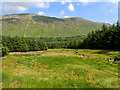
Mullochbuie
by Mick Garratt geograph for square NM7282 A deserted settlement high above Loch nan Uamh (Loch of the caves).
In the... (more)
Tags:
top:Derelict, DisusedX
Deserted
subject:RuinX
SettlementX
top:UplandsX
VillageX
top:Village, Rural SettlementX
|
|
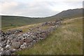
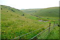
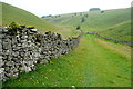
Bridleway through Long Dale
by Graham Horn geograph for square SK1959 The bridleway follows the dale floor here on a good track. It seemed to be... (more)
|
|
In Long Dale
by Graham Horn geograph for square SK1960 The stone walls funnel the bridleway to a gate here, in the bottom of the dale.... (more)
|
|
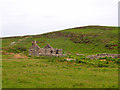
Gable End of Mountain View
by Trevor Littlewood geograph for square SD6998 From this view Mountain View might be thought to be an intact and even an... (more)
Tags:
top:Derelict, DisusedX
Deserted
Farm RoadX
top:Farm, Fishery, Market GardeningX
FarmhouseX
top:Roads, Road TransportX
top:UplandsX
|
|
Dorthgill
by Trevor Littlewood geograph for square NY7537 Dorthgill is a deserted farmstead in the valley of the River South Tyne; it... (more)
|
|
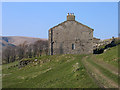
Bare House
by Mick Garratt geograph for square SE0066 |
|
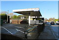
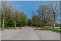
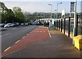
Newbridge railway station bus stop and taxi rank
by Jaggery geograph for square ST2196 No taxis and no-one waiting for a bus (or on the railway station) at 8.30am on a... (more)
|
|
Bridleway through Long Dale
by Graham Horn geograph for square SK1960 The bridleway follows the valley floor on a lovely remote path, before climbing... (more)
|
|
Dunan 18th-Century Township
by Mick Garratt geograph for square NG4016 See Link
Tags:
18th CenturyX
top:Derelict, DisusedX
Deserted
top:Farm, Fishery, Market GardeningX
type:GeographX
subject:Historic BuildingX
top:Historic Sites and ArtefactsX
RuinX
TownshipX
|
|
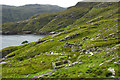
Gearraidh Lotalgear
by Mick Garratt geograph for square NB2201 Compared to west coast the east coast of Harris is rugged and harsh, lacking the... (more)
|
|
Abandoned Settlement of Tomnamoine
by Mick Garratt geograph for square NO0389 |
|
Bare House
by Mick Garratt for square SE0066 |
|
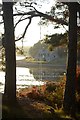
Empty Rope Swing at Littleferry
by Andrew Tryon geograph for square NH8095 The empty rope swing and uninhabited cottage on the shore of Loch Fleet have a... (more)
|