Geograph - photograph every grid square
About tags on Geograph
Tags
Geographical Context
Subjects
Types
Other Prefixes
Public Tags
Related Tags
|
Coverage Map
Tag:
Developing·Saltmarsh
Showing images tagged with
Developing Saltmarsh
tag.
View all tagged images
-
In Browser
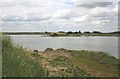
Breached Sea Wall
by
Paul Franks
geograph for square
TL9611
The sea wall here has been breached to create new saltmarsh habitat, and to help... (
more
)
Tags:
Developing Saltmarsh
top:
Estuary, Marine
X
Flooded Saltmarsh
X
type:
Geograph
X
Seawall
X
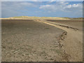
Channel through the developing saltmarsh, Holkham Bay
by
Pauline E
geograph for square
TF8945
Note the breach in the dune ridge to the left.
Tags:
top:
Coastal
X
Developing Saltmarsh
Dunes
X
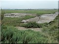
Volunteer marsh and Parrinder hide, RSPB Titchwell
by
Christine Johnstone
geograph for square
TF7544
This was a brackish lagoon, but in 2008 the east bank was deliberately breached... (
more
)
Tags:
Developing Saltmarsh
type:
Geograph
X
top:
Lakes, Wetland, Bog
X
subject:
Nature Reserve
X
RSPB Titchwell
X
Volunteer
X
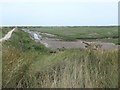
Volunteer marsh, RSPB Titchwell
by
Christine Johnstone
geograph for square
TF7544
About an hour after low tide. This was a brackish lagoon, but in 2008 the east... (
more
)
Tags:
Developing Saltmarsh
top:
Estuary, Marine
X
type:
Geograph
X
subject:
Nature Reserve
X
RSPB Titchwell
X
Volunteer
X
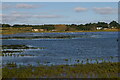
Hazlewood Marshes, from the path to the Eric Hosking Hide
by
Christopher Hilton
geograph for square
TM4357
Tags:
river:
Alde
X
near:
Aldeburgh
X
looking towards:
Aldeburgh
X
Developing Saltmarsh
top:
Estuary, Marine
X
type:
Geograph
X
Salt Marsh
X
subject:
Salt Marsh
X
Salt Marshes
X
Salt-Marsh
X
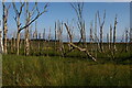
Dead birch trees on the edge of Hazlewood Marshes
by
Christopher Hilton
geograph for square
TM4358
Tags:
Birch
X
trees:
Birch
X
tree:
Birch
X
Birch Trees
X
Dead Trees
X
Developing Saltmarsh
top:
Estuary, Marine
X
type:
Geograph
X
top:
Lakes, Wetland, Bog
X
Reed Bed
X
Reed Beds
X
Reed-Beds
X
plant:
Reeds
X
Reeds
X
Salt Marsh
X
Salt Marshes
X
Salt-Marsh
X
Trees
X
View more in the Image Search
or
in Browser
View images matching 'Developing Saltmarsh' anywhere
in
the tags
Don't click these:
PotMel 1
PotMel 2
☰
Home
View
Search
Marked Images
Maps
Browser
Explore
Showcase
New Images
Collections
Interact
Games
Discussions
Blog
Contributors
Submit
Statistics
Leaderboards
General
FAQ
Help Pages
Sitemap
Contact Us
Support Us
sponsored by
🔍
What to search:
Photos
Enter keywords or a location/postcode to search nearby images
Enter a Grid Reference
Placenames
Collections
Website Pages
Everything
Others:
Advanced Search
|
Image Browser
Or:
Coverage Map
|
Searchable Map
You are not logged in
login
|
register