Public Tags
Tag: Dolmen
Other tags: subject:Dolmen
Showing images tagged with Dolmen tag.
|
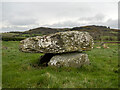
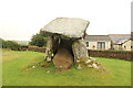
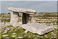
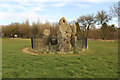
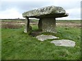
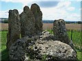
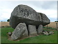
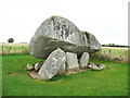
Lough Money Dolmen
by Rossographer for square J5346 Neolithic dolmen in a field a few miles east of Downpatrick near Saul. Detailed... (more)
Tags:
Chambered GraveX
type:Close LookX
Dolmen
place:DownpatrickX
DownpatrickX
top:Historic Sites and ArtefactsX
subject:HistoricalX
NeolithicX
period:NeolithicX
Neolithic Burial ChamberX
Neolithic SiteX
Portal DolmenX
place:SaulX
|
|
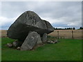
Lough Money Dolmen
by Rossographer geograph for square J5346 Neolithic dolmen in a field a few miles east of Downpatrick near Saul. Detailed... (more)
Tags:
Chambered GraveX
Dolmen
place:DownpatrickX
DownpatrickX
type:GeographX
top:Historic Sites and ArtefactsX
subject:HistoricalX
NeolithicX
period:NeolithicX
Neolithic Burial ChamberX
Neolithic SiteX
Portal DolmenX
place:SaulX
|
|
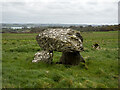
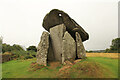
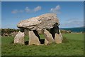
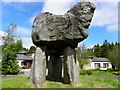
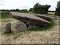
Kilclooney Dolmen
by Rossographer geograph for square G7296 Dolmen at Kilcooney around 3km south of Portnoo / 5km north of Ardara. See... (more)
Tags:
Dolmen
type:GeographX
top:Historic Sites and ArtefactsX
subject:HistoricalX
NeolithicX
period:NeolithicX
Neolithic Burial ChamberX
Neolithic SiteX
Neolithic TombX
Portal DolmenX
Portal TombX
|
|
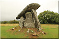
Trethevy Quoit
by Richard Croft for square SX2568 Neolithic dolmen with a 200 tonne capstone near Tremar, known locally as... (more)
|
|
Trethevy Quoit
by Richard Croft geograph for square SX2568 Neolithic dolmen with a 200 tonne capstone near Tremar, known locally as... (more)
|
|
Trethevy Quoit
by Richard Croft geograph for square SX2568 Neolithic dolmen with a 200 tonne capstone near Tremar, known locally as... (more)
|
|
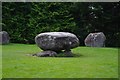
Dolmen in stone circle, Kenmare, Co Kerry
by P L Chadwick geograph for square V9070 The dolmen (single chamber megalithic tomb) is in the middle of the circle.... (more)
|
|
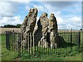
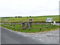
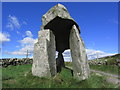
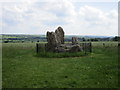
The Whispering Knights
by Rob Farrow geograph for square SP2930 Unfortunately it has been deemed necessary to surround the ancient stones known... (more)
Tags:
Burial ChamberX
subject:Dolmen
top:Historic Sites and ArtefactsX
Neolithic Burial ChamberX
place:Rollright StonesX
top:Village, Rural SettlementX
|
|
"Dolmen" at Tullagh Lower
by Oliver Dixon geograph for square R2093 Located at a junction on the R476 Kilfenora to Corofin road, this... (more)
|
|
The Whispering Knights
by Derek Harper geograph for square SP2930 "The Whispering Knights portal dolmen is the easternmost example of its... (more)
Tags:
Dolmen
type:GeographX
top:Historic Sites and ArtefactsX
top:LowlandsX
RailingsX
top:Rocks, Scree, CliffsX
Scheduled MonumentX
WoodX
top:Woodland, ForestX
|
|
The Whispering Knights
by Derek Harper geograph for square SP2930 "The Whispering Knights portal dolmen is the easternmost example of its... (more)
|
|
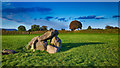
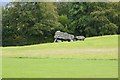
Giant's Ring Dolmen
by Peter Moore geograph for square J3267 Looking north east from the dolmen at the centre of the henge to the impressive bank
|
|
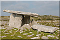
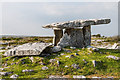
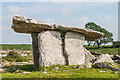
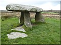
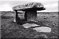
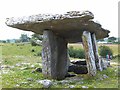
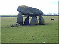
Poulnabrone dolmen
by Ian Capper geograph for square M2300 A Neolithic portal tomb which excavations in the 1980s showed to date from... (more)
Tags:
top:Barren PlateauxX
top:Burial Ground, CrematoriumX
near:CarrenX
Dolmen
top:Historic Sites and ArtefactsX
Portal TombX
Poulnabrone DolmenX
top:UplandsX
|
|
Poulnabrone dolmen
by Ian Capper geograph for square M2300 A Neolithic portal tomb which excavations in the 1980s showed to date from... (more)
Tags:
top:Barren PlateauxX
top:Burial Ground, CrematoriumX
near:CarrenX
Dolmen
top:Historic Sites and ArtefactsX
Portal TombX
place:PoulnabroneX
Poulnabrone DolmenX
top:UplandsX
|
|
Poulnabrone dolmen
by Ian Capper geograph for square M2300 A Neolithic portal tomb which excavations in the 1980s showed to date from... (more)
Tags:
top:Barren PlateauxX
top:Burial Ground, CrematoriumX
near:CarrenX
Dolmen
top:Historic Sites and ArtefactsX
Portal TombX
place:PoulnabroneX
Poulnabrone DolmenX
top:UplandsX
|
|
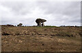
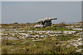
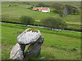
Dolmen, Stranakirk
by Kenneth Allen geograph for square G6082 Viewed from here G6082 : Stranakirk Townland
Tags:
Dolmen
top:Historic Sites and ArtefactsX
|
|
Frosty dolmen, Glenpark Estate
by Kenneth Allen geograph for square H4881 Pictured along Gortin Road
|
|
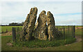
The Whispering Knights
by Richard Croft geograph for square SP2930 Dolmen of a Neolithic long barrow c3000 BC part of The Rollright Stones site... (more)
|
|
The Whispering Knights
by Richard Croft geograph for square SP2930 Dolmen of a Neolithic long barrow c3000 BC part of The Rollright Stones site... (more)
|
|
Legananny Dolmen near Slieve Croob
by Colin Park geograph for square J2843 |
|
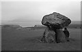
Lanyon Quoit
by Philip Halling geograph for square SW4233 Lanyon Quoit is a dolmen on Penwith Moor, it collapsed in a storm in 1815 and... (more)
Tags:
Dolmen
type:GeographX
top:Historic Sites and ArtefactsX
top:MoorlandX
MoorlandX
subject:Standing StoneX
Standing StonesX
|
|
Lanyon Quoit
by Philip Halling geograph for square SW4233 Lanyon Quoit is a dolmen on Penwith Moor, it collapsed in a storm in 1815 and... (more)
Tags:
Dolmen
type:GeographX
top:Historic Sites and ArtefactsX
top:MoorlandX
MoorlandX
subject:Standing StoneX
Standing StonesX
|
|
Lanyon Quoit
by Philip Halling geograph for square SW4233 Lanyon Quoit is a dolmen on Penwith Moor, it collapsed in a storm in 1815 and... (more)
Tags:
Dolmen
type:GeographX
top:Historic Sites and ArtefactsX
MoorlandX
subject:Standing StoneX
Standing StonesX
|
|
Druid's Plantation folly
by Richard Croft geograph for square SE1778 Folly Dolmen in Druid's Plantation built c1800 by William Danby of Swinton Park
|
|
Carreg Samson burial ground, near Abercastle
by Becky Williamson geograph for square SM8433 A 5000 year old Neolithic burial chamber or dolmen, half a mile west of... (more)
Tags:
Burial ChamberX
subject:Burial GroundX
top:Burial Ground, CrematoriumX
Dolmen
top:Historic Sites and ArtefactsX
period:NeolithicX
place:PembrokeshireX
country:WalesX
|
|
Ore stabit fortis arare placet ore stat
by Rob Farrow geograph for square SP2930 The Oxfordshire countryside to the south of the Rollright Stones forms a lovely... (more)
Tags:
Burial ChamberX
subject:Dolmen
top:Historic Sites and ArtefactsX
Neolithic Burial ChamberX
OxfordshireX
place:Rollright StonesX
top:Village, Rural SettlementX
|
|
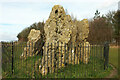
The Whispering Knights - Collapsed Cap Stone
by Rob Farrow geograph for square SP2930 I think that the recumbent stone nearest the camera was probably the Cap Stone... (more)
Tags:
Burial ChamberX
subject:Dolmen
top:Historic Sites and ArtefactsX
Neolithic Burial ChamberX
place:Rollright StonesX
top:Village, Rural SettlementX
|
|
Cromlech at Plas Newydd
by Philip Halling geograph for square SH5169 This Cromlech or in English Dolmen, an ancient burial chamber is in the parkland... (more)
|
|
Poulnabrone Portal Tomb
by Oliver Dixon geograph for square M2300 Famous dolmen off the R480. Very much on the tourist trail, as can be seen from... (more)
|
|
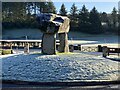
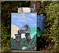
Air-quality monitoring station, Dundonald
by Albert Bridge for square J4274 An air-quality monitoring station, embellished by a painting of a dolmen, on the... (more)
|
|
Dolmen, Ulster History Park , Cullion
by Kenneth Allen geograph for square H4881 It is most likely that the JCB assisted in the placement of these stones here... (more)
|
|
Carreg Samson
by Eirian Evans geograph for square SM8433 A Neolithic dolmen in a field just west of Abercastle.
Tags:
subject:Ancient SiteX
Burial ChamberX
top:Burial Ground, CrematoriumX
top:CoastalX
Dolmen
type:GeographX
top:Geological InterestX
top:Historic Sites and ArtefactsX
period:NeolithicX
top:Religious SitesX
|
|
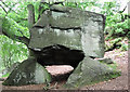
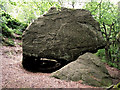
Gawton's Rock
by Jonathan Kington geograph for square SJ9055 Also known as Gawton's Dolmen and The Healing Stone this arrangement of... (more)
Tags:
BouldersX
place:Country ParkX
Country ParkX
Dolmen
Healing StoneX
HermitX
top:Historic Sites and ArtefactsX
top:PathsX
RocksX
StructureX
TreesX
top:Woodland, ForestX
|
|
Carreg Samson
by Philip Halling geograph for square SM8433 Carreg Samson comprises a large capstone 4.5 metres long by over 2.7 metres wide... (more)
|
|
The Whispering Knights
by Jonathan Thacker geograph for square SP2930 The remains of a burial chamber dating back to 3,800 BC... (more)
Tags:
Burial ChamberX
top:Burial Ground, CrematoriumX
Dolmen
type:GeographX
top:Historic Sites and ArtefactsX
|
|
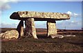
Lanyon Quoit
by Philip Halling geograph for square SW4233 Lanyon Quoit with the remains of an engine house on the horizon in the... (more)
|
|
Lanyon Quoit
by Philip Halling geograph for square SW4233 Impressive remains of a burial chamber.
|
|
Devil's Den from the bridleway in Clatford Bottom
by Jim Champion geograph for square SU1569 View south-west from the bridleway that runs up Clatford Bottom from the A4 road... (more)
|
|
Brownshill Portal Tomb
by Eirian Evans for square S7576 It is called a portal tomb as it has two tall portal stones at the entrance,... (more)
Tags:
subject:Ancient SiteX
top:Burial Ground, CrematoriumX
type:Close LookX
Dolmen
top:Flat LandscapesX
top:Historic Sites and ArtefactsX
Portal TombX
|
|
Brownshill Portal Tomb
by Eirian Evans geograph for square S7576 It is called a portal tomb as it has two tall portal stones at the entrance,... (more)
Tags:
subject:Ancient SiteX
top:Burial Ground, CrematoriumX
Dolmen
type:GeographX
top:Historic Sites and ArtefactsX
top:LowlandsX
Portal TombX
|
|
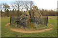
Arthur's Stone
by Philip Halling geograph for square SO3143 Arthurs Stone is a Neolithic chambered tomb, possibly more than over 5,000... (more)
Tags:
BarrowX
Dolmen
type:GeographX
top:Historic Sites and ArtefactsX
subject:HistoricalX
top:Religious SitesX
|
|
Lanyon Quoit and distant view of the Ding Dong Mine
by Christopher Hilton geograph for square SW4233 Two layers of Cornwall's past, separated by a few thousand years.
Tags:
ChimneyX
subject:CromlechX
CromlechX
Ding Dong Mine ChimneyX
Dolmen
top:Historic Sites and ArtefactsX
former:MineX
former:Mine BuildingX
Mine ChimneyX
top:MoorlandX
top:Quarrying, MiningX
|

|
Lanyon Quoit and distant view of the Ding Dong Mine
by Christopher Hilton geograph for square SW4233 Two layers of Cornwall's past, separated by a few thousand years.
Tags:
ChimneyX
CromlechX
Dolmen
top:Historic Sites and ArtefactsX
former:MineX
former:Mine BuildingX
Mine ChimneyX
top:Quarrying, MiningX
|
|
Brownshill Portal Tomb
by Humphrey Bolton geograph for square S7576 The information board in the car park states that this "was built as a... (more)
Tags:
subject:Ancient SiteX
Dolmen
top:GrasslandX
top:Historic Sites and ArtefactsX
top:LowlandsX
Portal TombX
|
|
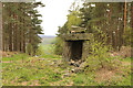
Another view of Gawton's Rock
by Jonathan Kington for square SJ9055 An opposite view to SJ9055 : Gawton's Rock showing the alcove where the hermit is reputed... (more)
|