Public Tags
Tag: Edge
Showing latest 50 of 102 images tagged with Edge tag.
|
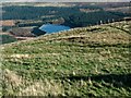
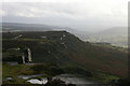
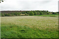
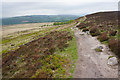
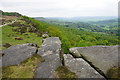
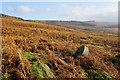
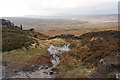
Edge of Holme Moss
by Gerald England geograph for square SE0903 Scrubland on the edge of Holme Moss. Over the edge in the distance is a glimpse... (more)
|
|
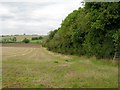
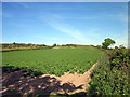
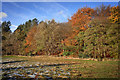
The edge of Heath End Plantation
by David P Howard geograph for square SP2361 Category: Woodland edge View north from the bridleway along the edge of the wood.
|
|
Edge on Edge Moor
by Bill Boaden geograph for square SK3555 This is looking up a gentle slope. The edge is only tiny but nevertheless stands... (more)
|
|
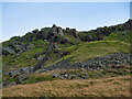
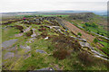
Blackstone Edge
by Bill Boaden geograph for square SK2673 The line of Gardom's Edge is prominent on the other side of Bar Brook, with... (more)
|
|
Curbar, one of the Derbyshire Edges
by Malcolm Neal geograph for square SK2575 These gritstone edges are where many people cut their teeth climbing. The edges... (more)
|
|
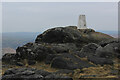
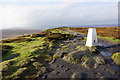
Trig Point on Blackstone Edge
by Chris Heaton geograph for square SD9716 Unusual for a triangulation column to be set on bare rock.
It overlooks a deep... (more)
Tags:
BouldersX
Edge
type:GeographX
Gritstone RocksX
Open AccessX
national trail:Pennine WayX
Triangulation ColumnX
top:UplandsX
|
|
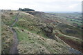
Path above Coombes Edge
by Bill Boaden geograph for square SK0191 This section is part of the Cown Edge Way. It was the day after the clocks... (more)
|

|
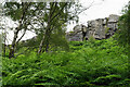
Coombes Edge
by Bill Boaden geograph for square SK0192 The edge forms a big curve. It is thought to be created by a natural landslip,... (more)
|
|
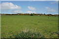
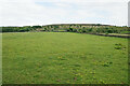
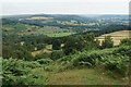
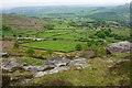
Field below Fallinge Edge
by Bill Boaden geograph for square SK2665 Looking uphill from a footpath which traverses the fields below the edge.
|
|
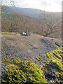
Dandelion field below Fallinge Edge
by Bill Boaden geograph for square SK2766 You can see a bit of the effect of quarrying on top of the edge.
|
|
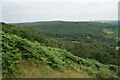
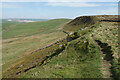
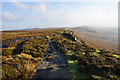
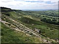
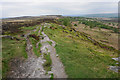
Path on Short Edge
by Bill Boaden geograph for square SK0578 The edge gives extensive views to the north east.
|
|
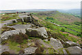
Blackstone Edge
by Bill Boaden geograph for square SK2673 The top of the edge near Wellington's Monument with a view down the Derwent valley.
|
|
Birchen Edge
by Bill Boaden geograph for square SK2772 Seen from a path which runs below the edge.
|
|
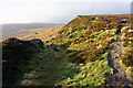
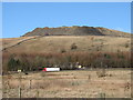
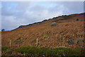
Langfield Edge
by David Dixon geograph for square SD9422 Looking up, from the Pennine Bridleway, towards the gritstone escarpment of... (more)
Tags:
Edge
EscarpmentX
type:GeographX
top:Geological InterestX
Gritstone OutcropX
MoorlandX
camera:Panasonic DC-G9X
PennineX
top:UplandsX
|
|
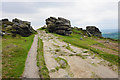
Path off Stanage Edge
by Bill Boaden geograph for square SK2385 There are occasional opportunities to get up or down the edge without... (more)
|
|
Stanage Edge
by Bill Boaden geograph for square SK2385 Looking south east along the edge from near High Neb. The higher point ahead is... (more)
|
|
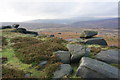
Rocks on White Edge
by Bill Boaden geograph for square SK2677 This edge does not have too many in the way of dramatic rocks, but nevertheless... (more)
|
|
Footpath on White Edge
by Bill Boaden geograph for square SK2676 Compared with some locally, this is quite a small edge.
|
|
Curbar Edge
by Bill Boaden geograph for square SK2574 Heading towards Curbar Gap with Baslow Edge continuing on the other side of the road.
|
|
Curbar from Curbar Edge
by Bill Boaden geograph for square SK2574 The lower end of Curbar Edge, but it still has views over the Derwent valley.
Tags:
Edge
top:Farm, Fishery, Market GardeningX
FieldsX
top:Roads, Road TransportX
top:Rocks, Scree, CliffsX
top:UplandsX
top:Village, Rural SettlementX
|
|
The southern end of Curbar Edge
by Bill Boaden geograph for square SK2575 You can see the road coming up from Curbar, with Baslow Edge beyond. The Derwent... (more)
|
|
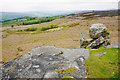
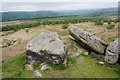
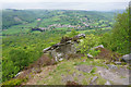
Rocks above the Derwent valley
by Bill Boaden geograph for square SK2576 You can see quite a way down the Derwent valley from here, including Chatsworth.... (more)
|
|
Harrol Edge
by Jeff Buck geograph for square SJ5175 The view towards Harrol Edge from Manley Road.
|
|
Clifftop at Chatsworth Park
by Trevor Rickard geograph for square SK2669 Looking south along the Derwent valley from a massive Millstone Grit boulder,... (more)
|
|
Hey Edge
by Ian Paterson geograph for square SK0799 Viewed from the permissive footpath alongside Torside reservoir.
|
|
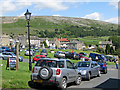
A honeypot for tourists and walkers
by Pauline E geograph for square SE0399 A view to Fremington Edge from the Dales village of Reeth. A sunny Sunday brings... (more)
|
|
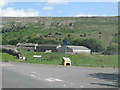
View to Fremington Edge
by Pauline E geograph for square SE0399 View across Town End Hall and Arkle Beck from the junction of Hill Close and... (more)
|
|
Cown Edge and The Mare's Back
by David Lally for square SK0191 A landslip feature.
|
|
Deer Stones Edge looking South
by Chris Heaton geograph for square SE0029 |
|
Wood Edge
by Mick Garratt geograph for square SE1653 |
|
Bamford Edge from below
by Bill Boaden geograph for square SK2084 Looking uphill from New Road.
|
|
Discarded millstone below Stanage Edge
by Bill Boaden geograph for square SK2284 A relic of a former local industry.
|
|
Trig point on High Neb
by Bill Boaden geograph for square SK2285 The highest point of Stanage Edge. Win Hill is prominent in the distance.
|
|
Small stream going over Stanage Edge
by Bill Boaden geograph for square SK2285 The flow of this stream is entirely seasonal, being dry for most of the year.
|
|
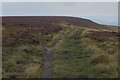
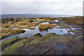
Path on Stanage End
by Bill Boaden geograph for square SK2286 Fairly wet after recent rain, but being near an edge and with many rocks, there... (more)
|
|
Rocks on Stanage End
by Bill Boaden geograph for square SK2286 This is the northern end of the long edge, with views to Ladybower and the hills... (more)
|
|
Footpath on White Edge
by Bill Boaden geograph for square SK2677 |
|
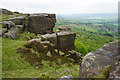
Rocks on White Edge
by Bill Boaden geograph for square SK2576 The distant view is up the Derwent valley.
|
|
Rock faces on Curbar Edge
by Bill Boaden geograph for square SK2575 The villages of Curbar and Calver are below in the valley.
|
|
Getting onto Curbar Edge
by Bill Boaden geograph for square SK2575 There are views over quite a length of the Derwent valley.
|
|
Rocks and birch trees on Froggatt Edge
by Bill Boaden geograph for square SK2476 You can see a bit of Grindleford in the Derwent valley below.
|
|
Path through rocks on Froggatt Edge
by Bill Boaden geograph for square SK2476 The Derwent valley is down to the right.
|
|
Rocky outcrop on Froggatt Edge
by Bill Boaden geograph for square SK2477 It gives the chance to look down onto Grindleford in the Derwent valley.
|
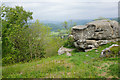
|
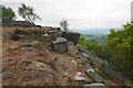
Outcrop above the Derwent valley
by Bill Boaden geograph for square SK2577 This outcrop sticks out on a slightly gentler section of the edge.
|
|
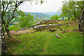
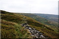
Broken down wall on Lightens Edge
by Bill Boaden geograph for square SE1003 The wall may not be effective as a wall, but it guides the path well. The Holme... (more)
|
|
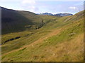
SW Slope of Robinson
by Mick Garratt geograph for square NY2017 Looking up towards Littledale Edge.
|
|
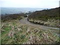
Millennium Way, Hare Hill Edge
by Christine Johnstone geograph for square SE0038 Dropping down from the Harehill House access track.
|
|
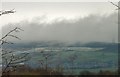
Matley Moor from Morrisons
by Gerald England for square SJ9796 A view of Matley Moor and Harrop Edge taken with a zoomed lens from Morrisons... (more)
|
|
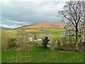
View from Carr Lane
by Paul Buckingham geograph for square SK1983 Carr Bottom Farm is visible in the middle ground with Bamford Moor and Edge in... (more)
|
|
Woodland by West Green Common
by Mr Ignavy geograph for square SU7456 Category: Woodland edge |