Public Tags
Tag: Feeder·Canal
Other tags: place:Feeder Canal
Showing images tagged with Feeder Canal tag.
|
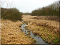
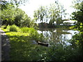
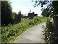
The Dane feeder to Rudyard Lake
by Stephen Craven geograph for square SJ9361 Along with several natural streams the lake was originally fed by this feeder... (more)
|
|
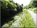
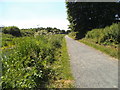
Feeder Canal View
by Gordon Griffiths geograph for square SO9187 The view down the towpath of the Stourbridge Feeder Canal off Pensnett Road, Dudley.
Tags:
disused:CanalX
Canal TowpathX
top:CanalsX
place:DudleyX
Feeder Canal
Nature ReserveX
Stourbridge CanalX
|
|
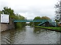
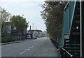
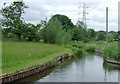
2011 : Feeder Road, St. Philip's Marsh, Bristol
by Maurice Pullin geograph for square ST6072 Looking east.
The ramp to the left leads up to a footbridge and cycleway over... (more)
Tags:
place:BristolX
top:Business, Retail, ServicesX
top:CanalsX
top:City, Town CentreX
CyclewayX
place:Feeder CanalX
place:Feeder RoadX
FootbridgeX
top:PathsX
Railway BridgeX
top:RailwaysX
RoadX
top:Roads, Road TransportX
|
|
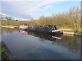
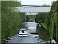
Working Narrow Boat Hadar moored near Smeeton Aqueduct
by Keith Lodge geograph for square SP6792 Working Narrow Boat Hadar moored near Smeeton Aqueduct, January 2012, opposite... (more)
|
|
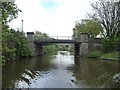
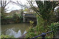
Silverthorne Lane Bridge, from the west
by Christine Johnstone geograph for square ST6072 Carrying a public footpath over Bristol's Feeder Canal.
Tags:
subject:BridgeX
top:CanalsX
place:Feeder CanalX
Feeder Canal
bridge:FootbridgeX
bridge:Footpath Over CanalX
|
|
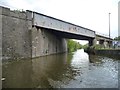
Skew bridge, from the west
by Christine Johnstone geograph for square ST6072 Carrying a railway line across Bristol's Feeder Canal.
Tags:
subject:BridgeX
top:CanalsX
place:Feeder CanalX
Feeder Canal
bridge:Railway Over CanalX
top:RailwaysX
Skew BridgeX
|
|
Barton Hill or Marsh Lane Bridge, from the west
by Christine Johnstone geograph for square ST6172 Carrying Marsh Lane over Bristol's Feeder Canal.
|
|
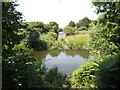
Canal feeder channel, Llangynidr
by Jaggery geograph for square SO1419 Water from a nearby river, Afon Crawnon, replenishes the Monmouthshire and... (more)
|
|
Bridge over the Black Weir Docks Feeder
by Guy Butler-Madden geograph for square ST1875 The Black Weir feeder supplied water from the Taff to Bute East and West Docks.... (more)
Tags:
top:CanalsX
Cardiff DocksX
top:City, Town CentreX
Dock Water FeederX
top:Docks, HarboursX
Feeder Canal
top:Flat LandscapesX
|
|
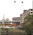
2011 : Feeder Road, St. Philip's Marsh, Bristol
by Maurice Pullin geograph for square ST6072 Looking west toward Temple Meads Station.
Tower flats in the Redcliffe area are... (more)
Tags:
place:BristolX
top:CanalsX
top:City, Town CentreX
place:Feeder CanalX
place:Feeder RoadX
FootbridgeX
top:Housing, DwellingsX
top:PathsX
top:Roads, Road TransportX
|
|
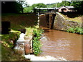
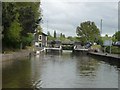
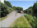
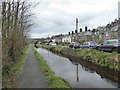
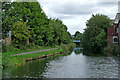
Netham Lock, Feeder Canal, Bristol
by Christine Johnstone geograph for square ST6172 The lock only functions at the highest tides, when water comes over the weir... (more)
|
|
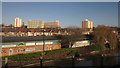
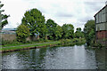
Industry by The Feeder
by Derek Harper geograph for square ST6072 Industrial units on the Barton Hill Trading Estate, beside The Feeder, a canal... (more)
Tags:
CanalX
top:CanalsX
ChurchX
Feeder Canal
High Rise FlatsX
top:Housing, DwellingsX
Industrial EstateX
Industrial UnitsX
top:IndustryX
top:LowlandsX
top:Religious SitesX
top:Suburb, Urban FringeX
|
|
2011 : Feeder Canal, Bristol looking east
by Maurice Pullin geograph for square ST6072 Toward Netham Lock and the River Avon.
"Construction started in 1804 to... (more)
Tags:
place:BristolX
top:CanalsX
top:City, Town CentreX
top:Docks, HarboursX
place:Feeder CanalX
person:William JessopX
|
|
Marsh Bridge Vicinity, Bristol
by David Hallam-Jones geograph for square ST6072 The far side of a winding hole, i.e. an enlargement in which narrow boats and... (more)
Tags:
top:CanalsX
top:City, Town CentreX
top:Construction, DevelopmentX
Feeder Canal
type:GeographX
Marsh BridgeX
|
|
Junction Footbridge
by Gordon Griffiths geograph for square SO9087 The view down the Stourbridge Feeder Canal at the junction with the Extension... (more)
Tags:
disused:CanalX
Canal FootbridgeX
Canal JunctionX
top:CanalsX
place:DudleyX
Feeder Canal
Former Railway BridgeX
Stourbridge CanalX
|
|
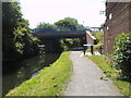
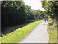
Britannia Bridge
by Gordon Griffiths geograph for square SO9087 The view down the towpath of the Stourbridge Feeder Canal near Pensnett, Dudley.
Tags:
disused:CanalX
Canal BridgeX
Canal TowpathX
top:CanalsX
place:DudleyX
Feeder Canal
Stourbridge CanalX
|
|
Canal Towpath View
by Gordon Griffiths geograph for square SO9087 The view down the towpath of the Stourbridge Feeder Canal off Pensnett Road, Dudley.
|
|
Tavistock Canal
by Chris Allen geograph for square SX4773 Although no longer used for navigation the canal acts as a feeder for the... (more)
|
|
Sluice View
by Gordon Griffiths geograph for square SO9188 The view of the Grove Pool Sluice into feeder canal part of the Stourbridge... (more)
|
|
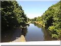
Wide Waters View
by Gordon Griffiths geograph for square SO9188 The view of the feeder canal part of the Stourbridge Canal in Fens Pools Nature... (more)
|
|
Wide Waters
by Gordon Griffiths geograph for square SO9188 The view of the feeder canal part of the Stourbridge Canal in Fens Pools Nature... (more)
|
|
Sunday Bike Ride
by Gordon Griffiths geograph for square SO9087 The view down the towpath of the Stourbridge Feeder Canal near Pensnett, Dudley.
Tags:
BikersX
disused:CanalX
Canal TowpathX
top:CanalsX
place:DudleyX
Feeder Canal
Stourbridge CanalX
|
|
Extension Canal
by Gordon Griffiths geograph for square SO9087 The view down the Extension off of the Stourbridge Feeder Canal at Pensnett, Dudley.
|
|
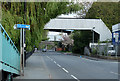
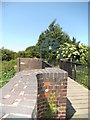
Cressett Lane Bridge
by Gordon Griffiths geograph for square SO9087 The view across the footbridge over the Stourbridge Feeder Canal in Dudley.
|
|
Footbridge View
by Gordon Griffiths geograph for square SO9087 The view to the footbridge over the Stourbridge Feeder Canal off Cressett Lane, Dudley.
|
|
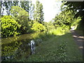
Canal feeder channel near Norton Green, Stoke-on-Trent
by Roger D Kidd geograph for square SJ9051 This un-navigable channel brings in water to The Caldon Canal from the... (more)
Tags:
top:CanalsX
Feeder Canal
|
|
Stourbridge Canal (Fens Branch) near Brierley Hill, Dudley
by Roger D Kidd geograph for square SO9087 This is at Leys Junction. The Branch was constructed specifically as a feeder... (more)
|
|
Stourbridge Canal (Fens Branch) near Brierley Hill, Dudley
by Roger D Kidd geograph for square SO9087 This is at Leys Junction. The Branch was constructed specifically as a feeder... (more)
|
|
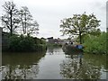
Netham Lock and its two bailey bridges
by Christine Johnstone geograph for square ST6172 The lock is used to keep high tides from the River Avon beyond out of the... (more)
|
|
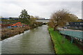
Canoeist passing anglers on the Feeder Canal
by Christine Johnstone geograph for square ST6072 Looking east, alongside the backs of factories in Silverthorne Lane.
Tags:
AnglersX
subject:CanalX
top:CanalsX
Canalside TreesX
CanoeistX
place:Feeder CanalX
top:Sport, LeisureX
|
|
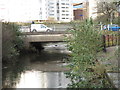
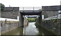
Barton Hill Bridge over Feeder Canal, Bristol
by Ian S geograph for square ST6172 Tags:
BridgeX
top:CanalsX
Feeder Canal
type:GeographX
top:Roads, Road TransportX
top:Suburb, Urban FringeX
|
|
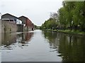
Feeder Canal, Bristol
by Ian S geograph for square ST6072 |
|
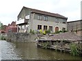
Clarks Wood Co, Timber Merchants
by Christine Johnstone geograph for square ST6072 On the north bank of Bristol's Feeder Canal. Once they probably used their... (more)
Tags:
subject:BuildingX
top:Business, Retail, ServicesX
former:Canal WharfX
place:Feeder CanalX
Timber MerchantsX
|
|
Narrows at Totterdown Basin entrance, from the north
by Christine Johnstone geograph for square ST5972 A convenient location for an angler. There is a sharp left [east] turn in the... (more)
|
|
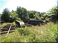
Old Freight Railway Line
by Gordon Griffiths geograph for square SO9087 The disused Dudley railway passes over the Stourbridge Canal.
Tags:
disused:CanalX
Feeder Canal
Freight Railway LineX
former:RailwayX
top:RailwaysX
Stourbridge CanalX
|