Public Tags
Tag: Former·Local·Authority·Boundary
Showing images tagged with Former Local Authority Boundary tag.
|
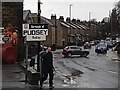
Sign for the former Borough of Pudsey
by Stephen Craven geograph for square SE2236 According to Wikipedia, Pudsey was a local government district in the West... (more)
|
|
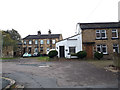
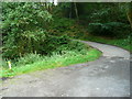
Woods Row / Wheaters Fold, off Town Street, Stanningley
by Stephen Craven geograph for square SE2234 Old buildings set back just off the main street.
The 1908 map shows that the... (more)
Tags:
top:Boundary, BarrierX
Former Local Authority Boundary
type:GeographX
top:Housing, DwellingsX
top:Suburb, Urban FringeX
|
|
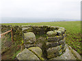
Boulder with castellated turret
by Stephen Craven geograph for square SE0839 This boulder is built into the corner of a dry stone wall, suggesting that it... (more)
|
|
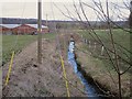
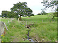
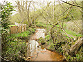
Bagley Beck
by Stephen Craven geograph for square SE2236 The beck marks the historic boundary between the former boroughs of Leeds and... (more)
|
|
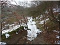
Hebden Bridge Footpath 11
by Humphrey Bolton geograph for square SD9926 This slopes down along the lower boundary of Crow Nest Wood. This is also the... (more)
Tags:
top:Boundary, BarrierX
Former Local Authority Boundary
top:LowlandsX
top:PathsX
Public FootpathX
Snow SceneX
top:Woodland, ForestX
|
|
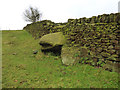
Boulder as boundary stone
by Stephen Craven geograph for square SE0840 The way this large boulder is incorporated into the corner of a stone wall... (more)
|
|
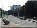
Boundary Lane, near Upton Park
by Malc McDonald geograph for square TQ4182 Boundary Lane, near Upton Park in East London.
This road would once have... (more)
Tags:
subject:BoundaryX
top:Boundary, BarrierX
near:East HamX
place:East LondonX
Former Local Authority Boundary
type:GeographX
near:Upton ParkX
|
|
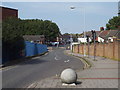
Dry Carr Lane, Midgley
by Humphrey Bolton geograph for square SE0328 The former Midgley Urban District was abolished in 1939 and split between... (more)
Tags:
top:Boundary, BarrierX
Former Local Authority Boundary
type:GeographX
subject:LaneX
top:LowlandsX
top:Roads, Road TransportX
top:Woodland, ForestX
|
|
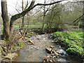
Shaw Beck, Yeadon
by Stephen Craven geograph for square SE2042 The beck is shown on older maps as an urban district boundary (between Yeadon,... (more)
|
|
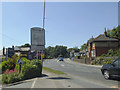
Welcome to Mirfield
by Stephen Craven geograph for square SE2119 The boundary between the Boroughs of Dewsbury and Mirfield ran along the main... (more)
|
|
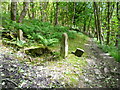
Gateway on the parish boundary
by Humphrey Bolton geograph for square SE1122 The ruined wall was the boundary between Elland and Southowram. The footpath... (more)
Tags:
top:Boundary, BarrierX
Former Local Authority Boundary
top:LowlandsX
subject:PathX
top:PathsX
Public FootpathX
top:Woodland, ForestX
|
|
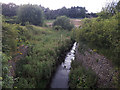
Red Beck upstream of Badger Lane
by Humphrey Bolton geograph for square SE1125 The orange ochre colour is perhaps why Red Beck was so called. It is the... (more)
Tags:
top:Boundary, BarrierX
Former Local Authority Boundary
type:GeographX
top:LowlandsX
stream:Red BeckX
top:Rivers, Streams, DrainageX
subject:StreamX
|
|
Red Beck downstream of Pinnel Bridge
by Humphrey Bolton geograph for square SE1224 Red Beck is the boundary between Hove Edge and Southowram.
Tags:
top:Boundary, BarrierX
Former Local Authority Boundary
type:GeographX
top:LowlandsX
stream:Red BeckX
top:Rivers, Streams, DrainageX
subject:StreamX
|
|
Farnley Wood Beck, Churwell
by Stephen Craven geograph for square SE2730 Viewed from Digpal Road. The beck was once the boundary between Morley and... (more)
|
|
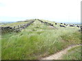
Lane on Worts Hill, Slaithwaite
by Humphrey Bolton geograph for square SE0615 See also SE0615 : Lane on Worts Hill, Slaithwaite for an earlier image. The summit of this track is only about... (more)
|