Public Tags
Showing images tagged with former:Harbour tag.
|
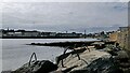
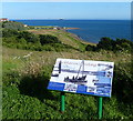
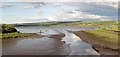
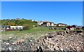
Sea defences, Wick, Caithness
by Claire Pegrum geograph for square ND3650 This used to be the site of Baikie's Harbour, one of several small harbours... (more)
|
|
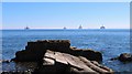
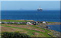
Oil rigs off Buckhaven
by Bill Kasman geograph for square NT3597 Oil rigs are often anchored in the Forth Estuary when between jobs or due for a... (more)
|
|
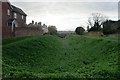
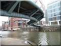
The Westport
by Bob Harvey geograph for square SY9287 Ancient Saxon harbour on the edge of Wareham
Tags:
top:Docks, HarboursX
Former HarbourX
former:Harbour
subject:Harbour
top:Historic Sites and ArtefactsX
top:LowlandsX
period:SaxonX
top:Suburb, Urban FringeX
|
|
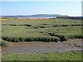
Salt marsh in the former Pembrey Harbour
by Simon Mortimer geograph for square SN4300 Looking south from the Wales Coast Path towards the Gower Peninsula. The... (more)
|
|
Information board overlooking the former Buckhaven Harbour
by Mat Fascione geograph for square NT3597 Buckhaven was once a thriving weaving village and fishing port, in 1831 it was... (more)
|
|
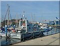
Hull Marina
by Lauren geograph for square TA0928 Hull Marina opened in 1983 on the site of the former Railway Dock and Humber Dock
|
|
The 'Long Hole', Bangor
by Rossographer geograph for square J5082 Dank best describes the 9th February 2013 - cold, dreary, with low cloud and... (more)
Tags:
top:Air, Sky, WeatherX
BangorX
place:BangorX
Bangor (Co Down)X
place:Bangor HarbourX
Bangor HarbourX
top:City, Town CentreX
top:CoastalX
top:Docks, HarboursX
former:Harbour
Harbour
Long HoleX
place:The Long HoleX
|
|
The 'Long Hole', Bangor
by Rossographer geograph for square J5082 The 'Long Hole' in Bangor on a bright, warm and sunny July morning -... (more)
Tags:
place:BangorX
BangorX
Bangor (Co Down)X
place:Bangor HarbourX
top:City, Town CentreX
top:CoastalX
top:Docks, HarboursX
Harbour
former:Harbour
Harbour (Disused)X
top:Historic Sites and ArtefactsX
Long HoleX
place:The Long HoleX
|
|
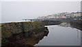
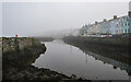
Dingwall Canal and Harbour
by valenta geograph for square NH5658 The River Peffrey drains into the Cromarty Firth by the old harbour entrance.... (more)
Tags:
disused:CanalX
top:CanalsX
top:CoastalX
firth:Cromarty FirthX
place:DingwallX
top:Docks, HarboursX
top:Estuary, MarineX
type:GeographX
former:Harbour
subject:MudX
river:River PefferyX
top:Rivers, Streams, DrainageX
place:Ross-ShireX
top:Suburb, Urban FringeX
The Black IsleX
|
|
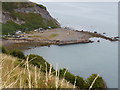
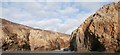
Abandoned harbour at Port Mulgrave
by Mat Fascione geograph for square NZ7917 The harbour was constructed in 1874 to deal with iron ore that was mined from... (more)
Tags:
CliffsX
top:CoastalX
top:Derelict, DisusedX
top:Docks, HarboursX
type:GeographX
subject:Harbour
former:Harbour
top:Rocks, Scree, CliffsX
|
|
The 'Long Hole', Bangor
by Rossographer geograph for square J5082 The 'Long Hole' on a pleasant November afternoon.
Tags:
place:BangorX
Bangor (Co Down)X
place:Bangor BayX
place:Bangor HarbourX
top:City, Town CentreX
CloudsX
top:CoastalX
top:Docks, HarboursX
former:Harbour
category:Harbour (Disused)X
place:The Long HoleX
|
|
Whinstone dyke at Nacker Hole
by Paul Franks geograph for square NU2329 The gap in the dyke was made in the middle of the 18th century by blasting, to... (more)
Tags:
top:CoastalX
top:Derelict, DisusedX
top:Docks, HarboursX
former:Harbour
top:Rocks, Scree, CliffsX
Whinstone DykeX
|
|
Floating Harbour at Temple Bridge
by Christine Johnstone geograph for square ST5972 This eastern end of the Floating Harbour is being steadily redeveloped with... (more)
Tags:
Development SiteX
top:Docks, HarboursX
bridge:FootbridgeX
FootbridgeX
former:Harbour
top:PathsX
|
|
The 'Long Hole', Bangor
by Rossographer geograph for square J5082 The 'Long Hole' on a calm but misty November morning.
|
|
Morrison's Haven
by Eirian Evans geograph for square NT3773 This was the site of a working harbour where timber, rock salt, gravel, stone... (more)
|
|
Huts near the old harbour at Buckhaven
by Mat Fascione geograph for square NT3597 Buckhaven was once a thriving weaving village and fishing port, in 1831 it was... (more)
Tags:
subject:CoastX
top:CoastalX
top:Docks, HarboursX
long distance path:Fife Coast PathX
place:Firth of ForthX
type:GeographX
former:Harbour
Oil RigX
|
|
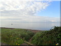
Cliffs by Porth Lleuog
by HelenK geograph for square SM6922 Porth Lleuog's name gives away that it is a poor quality harbour. It was... (more)
Tags:
BeachX
top:Docks, HarboursX
type:GeographX
former:Harbour
top:IslandsX
place:Ramsey IslandX
top:Rocks, Scree, CliffsX
|
|
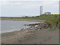
Shoreline at Prestongrange
by Alan Murray-Rust geograph for square NT3773 The tumbled stones include parts of the breakwaters of the long-disused... (more)
Tags:
top:CoastalX
top:Derelict, DisusedX
top:Docks, HarboursX
top:Energy InfrastructureX
former:Harbour
top:Historic Sites and ArtefactsX
Industrial ChimneyX
former:Power StationX
ShorelineX
|
|
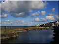
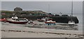
Old Harbour, Scarinish, Tiree
by Becky Williamson geograph for square NM0444 |
|
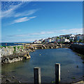
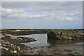
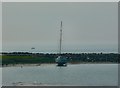
Port Logan Harbour
by Andy Farrington geograph for square NX0940 View across the harbour at low tide, a bit of a grey day.
|
|
Buckhaven
by Bill Kasman geograph for square NT3597 Seen from the end of the old harbour wall.
|
|
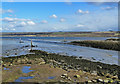
The Old Dingwall Harbour
by Mary and Angus Hogg geograph for square NH5658 The canal at Dingwall was built in 1817 in an attempt to develop the town as a... (more)
|
|
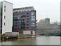
Live life to the full at Finzels Reach
by Christine Johnstone geograph for square ST5973 New flats alongside the Floating Harbour, opposite Castle Park.
|
|
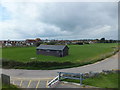
Harbour Field
by PAUL FARMER geograph for square TQ9116 This field is the site of an old harbour for Rye
|
|
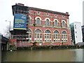
The former tramways electrical generating station
by Christine Johnstone geograph for square ST5972 Built in 1899. Now being redeveloped as a landmark building in the Finzels Reach... (more)
|
|
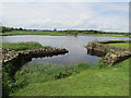
Harbour at Threave Castle
by Martin Dawes geograph for square NX7362 This was used by small boats bring in supplies for the castle. Excavations here... (more)
Tags:
top:Flat LandscapesX
former:Harbour
top:Historic Sites and ArtefactsX
River DeeX
top:Rivers, Streams, DrainageX
Threave CastleX
|