Public Tags
Other tags: Reservoir
abortive:Reservoir
boundary stone:Reservoir
category:Reservoir
disused:Reservoir
subject:Reservoir
Showing latest 50 of 99 images tagged with former:Reservoir tag.
|
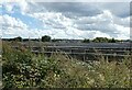
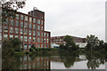
Crossness - Photovoltaic array above former reservoir
by Rob Farrow for square TQ4880 The site of the covered 25 million gallon sewage reservoir which covered 6 acres... (more)
Tags:
place:BelvedereX
Covered ReservoirX
type:Cross GridX
place:CrossnessX
top:Historic Sites and ArtefactsX
Photovoltaic ArrayX
former:Reservoir
Sewage Pumping StationX
Solar FarmX
subject:Solar PowerX
top:Suburb, Urban FringeX
top:Waste, Waste ManagementX
|
|
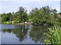
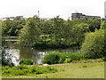
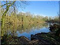
Stamford Park Upper Lake
by David Dixon geograph for square SJ9599 The former mill reservoir known as Chadwick Dams was incorporated into Stamford... (more)
Tags:
Angling ClubX
place:Ashton Under LyneX
Fishing LodgeX
LakeX
top:Lakes, Wetland, BogX
ParkX
top:Park and Public GardensX
former:Reservoir
top:Sport, LeisureX
place:StalybridgeX
top:Suburb, Urban FringeX
|
|
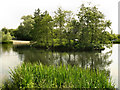
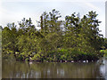
The Island, Stamford Park Upper Lake
by David Dixon geograph for square SJ9599 The former mill reservoir known as Chadwick Dams was incorporated into Stamford... (more)
Tags:
Angling ClubX
place:Ashton Under LyneX
Fishing LodgeX
IslandX
top:IslandsX
LakeX
top:Lakes, Wetland, BogX
ParkX
top:Park and Public GardensX
former:Reservoir
top:Sport, LeisureX
place:StalybridgeX
top:Suburb, Urban FringeX
|
|
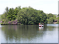
The Upper Lake, Stamford Park
by David Dixon geograph for square SJ9599 The former mill reservoir known as Chadwick Dams was incorporated into Stamford... (more)
Tags:
Angling ClubX
place:Ashton Under LyneX
Fishing LodgeX
IslandX
LakeX
top:Lakes, Wetland, BogX
top:Park and Public GardensX
top:Public Buildings and SpacesX
former:Reservoir
top:Sport, LeisureX
place:StalybridgeX
top:Suburb, Urban FringeX
|
|
Stamford Park Upper Lake
by David Dixon geograph for square SJ9599 The former mill reservoir known as Chadwick Dams was incorporated into Stamford... (more)
Tags:
Angling ClubX
place:Ashton Under LyneX
Fishing LodgeX
IslandX
LakeX
top:Lakes, Wetland, BogX
ParkX
top:Park and Public GardensX
former:Reservoir
place:StalybridgeX
top:Suburb, Urban FringeX
|
|
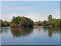
Stamford Park Lake and Island
by David Dixon geograph for square SJ9599 The boating lake and island, seen from Darnton Road.
The lake, formerly the... (more)
Tags:
place:Ashton Under LyneX
IslandX
LakeX
top:Lakes, Wetland, BogX
ParkX
top:Park and Public GardensX
top:Public Buildings and SpacesX
former:Reservoir
top:Sport, LeisureX
top:Suburb, Urban FringeX
|
|
Stamford Park Boating Lake
by David Dixon geograph for square SJ9599 The boating lake to the north of Darnton Road. The lake, formerly the mill... (more)
Tags:
place:Ashton Under LyneX
IslandX
LakeX
ParkX
top:Park and Public GardensX
former:Reservoir
top:Sport, LeisureX
Steam BoatX
top:Suburb, Urban FringeX
|
|
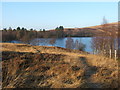
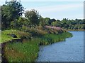
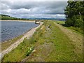
Carman Reservoir
by Lairich Rig geograph for square NS3778 Category: Reservoir In the foreground is a footpath that leads around the reservoir and towards... (more)
|
|
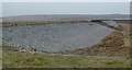
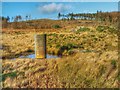
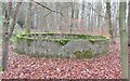
Former Barbrook Reservoir
by Andrew Hill geograph for square SK2877 A rather forlorn pool and the breached dam of the reservoir.
Tags:
place:Barbrook ReservoirX
Breached DamX
DamX
top:Lakes, Wetland, BogX
MoorlandX
former:Reservoir
disused:Reservoir
|
|
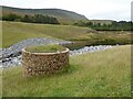
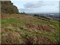
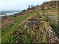
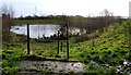
Site of the former dam
by Philip Halling geograph for square SO0318 Site of the former dam to the Lower Neuadd Reservoir. The ridge in the... (more)
|
|
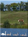
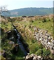
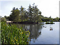
Swans on Lower Boat Pond
by Robin Drayton geograph for square SO1711 |
|
Lower Boat Pond
by Robin Drayton geograph for square SO1711 The southern edge taken from the car park.
|
|
The eastern end of Lower Boat Pond
by Robin Drayton geograph for square SO1711 The view from the small car park in Little Lane.
Tags:
place:BeaufortX
Local Nature ReserveX
former:Reservoir
top:Rivers, Streams, DrainageX
top:UplandsX
|
|
Lower Boat Pond, Beaufort
by Robin Drayton geograph for square SO1711 Viewed from Upper Boat Pond.
|
|
Upper Boat Pond, Beaufort
by Robin Drayton geograph for square SO1712 |
|
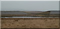
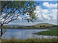
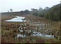
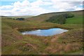
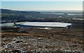
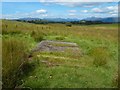
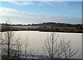
Former reservoir, Ramsley Moor
by Andrew Hill geograph for square SK2874 The northern edge of the former bed of the reservoir, now marshy ground with... (more)
|
|
Dam wall of the former Barbrook reservoir
by Andrew Hill geograph for square SK2877 Due to not being used as a water supply for some years, the reservoir was... (more)
Tags:
place:Barbrook ReservoirX
Breached DamX
DamX
top:Lakes, Wetland, BogX
MoorlandX
former:Reservoir
|
|
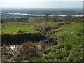
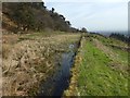
Overflow of former reservoir
by Lairich Rig geograph for square NS3581 See also NS3581 : Former reservoir and NS3581 : View of small loch.
The overflow, from the north-western... (more)
|
|
Old reservoir
by Lairich Rig geograph for square NS4674 In the right background, a part of the Clyde that is roughly aligned with the... (more)
|
|
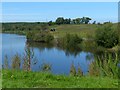
Westworth Reservoir
by Mick Garratt geograph for square NZ6313 Only a small pond now remains of this former reservoir which once supplied the... (more)
Tags:
top:Derelict, DisusedX
top:Lakes, Wetland, BogX
PondX
former:Reservoir
disused:Reservoir
subject:RuinX
RuinX
top:Water ResourcesX
|
|
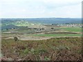
The former Baildon Water Works, Baildon Moor
by Christine Johnstone geograph for square SE1440 Three reservoirs, built in 1875 and now drained.
Tags:
Drained ReservoirX
subject:MoorlandX
Open Access LandX
Open Access MoorlandX
disused:Reservoir
former:Reservoir
top:Water ResourcesX
|
|
|
Carman Reservoir
by Lairich Rig geograph for square NS3778 See NS3778 : Carman Reservoir for much more on the reservoir. The present picture, a... (more)
Tags:
landmark:Carman HillX
top:Derelict, DisusedX
top:PathsX
former:Reservoir
top:Water ResourcesX
bucket:WideangleX
|
|
Disused Reservoir, Bollihope Limestone Quarry
by Mick Garratt geograph for square NZ0134 Tags:
top:Derelict, DisusedX
DisusedX
Disused QuarryX
LimestoneX
QuarryX
former:QuarryX
top:Quarrying, MiningX
former:Reservoir
disused:Reservoir
ReservoirX
top:Water ResourcesX
|
|
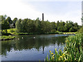
Cobden Mill, Moses Gate
by Alan Murray-Rust geograph for square SD7306 Reflected in the substantial lodge or reservoir which is now a fishing pond. The... (more)
Tags:
period:1890sX
Fishing PondX
Grade II ListedX
top:Historic Sites and ArtefactsX
top:IndustryX
Mill LodgeX
ReflectionX
former:Reservoir
top:Sport, LeisureX
top:Suburb, Urban FringeX
former:Textile MillX
|
|
The lodge, Cobden Mill, Moses Gate
by Alan Murray-Rust geograph for square SD7306 The lodge, or reservoir, has survived to become a fishing pond for a local... (more)
Tags:
period:1890sX
building material:BrickX
Fishing PondX
Grade II ListedX
top:Historic Sites and ArtefactsX
top:IndustryX
Mill LodgeX
former:Reservoir
top:Sport, LeisureX
top:Suburb, Urban FringeX
former:Textile MillX
|
|
Carman Reservoir frozen over
by Lairich Rig for square NS3778 For views from down at the far shore of the reservoir, see NS3778 : Carman Reservoir frozen over, looking... (more)
Tags:
type:Cross GridX
top:Derelict, DisusedX
landmark:Dumbarton RockX
landmark:Dumbuck QuarryX
subject:IceX
former:Reservoir
top:Water ResourcesX
|

|
Carman Reservoir: valve tower
by Lairich Rig geograph for square NS3778 A sluice would have been controlled from here. See NS3778 : Carman Reservoir: embankment for context and... (more)
|
|
Carman Reservoir: embankment
by Lairich Rig geograph for square NS3778 See NS3778 : Carman Reservoir for the details of the formation of the reservoir, and for other... (more)
|
|
Carman Reservoir
by Lairich Rig geograph for square NS3778 Before the reservoir (now disused) was formed, the body of water was called... (more)
Tags:
former:Reservoir
top:Water ResourcesX
|
|
|
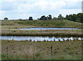
Harelaw Reservoir
by Lairich Rig geograph for square NS4859 Category: Reservoir Unlike nearby NS4760 : Glenburn Reservoir, Harelaw Reservoir appears on the first-edition OS... (more)
|
|
Old reservoir fishing lake
by Ian Calderwood geograph for square SK3116 On old maps, this fishing lake is marked as a reservoir but with no indication... (more)
Tags:
Fishing LakeX
type:GeographX
subject:LakeX
top:Lakes, Wetland, BogX
former:Reservoir
top:Sport, LeisureX
top:Water ResourcesX
|
|
Netley Park - Former Reservoir
by Colin Smith geograph for square TQ0748 Old circular, concrete structure on top of the chalky North Downs above Shere.
Tags:
type:GeographX
top:Historic Sites and ArtefactsX
former:Reservoir
subject:Reservoir
top:Water ResourcesX
|
|
Carman Reservoir: valve tower
by Lairich Rig geograph for square NS3778 See NS3778 : Carman Reservoir: valve tower for a view from much closer, and NS3778 : Carman Reservoir for much more on... (more)
|
|
Pools in the former Ramsley Reservoir
by Andrew Hill geograph for square SK2874 Looking southeast from the path, which has been redirected along the west rather... (more)
|
|
|
Former reservoir
by Lairich Rig geograph for square NS3581 This body of water is shown from a distance in NS3581 : View of small loch. It does not appear on... (more)
|
|
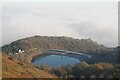
The Camp Reservoir
by Philip Halling for square SO7639 The Camp Reservoir viewed from the Herefordshire Beacon. There is a temperature... (more)
Tags:
top:Air, Sky, WeatherX
type:Cross GridX
subject:Reservoir
former:Reservoir
ReservoirX
Temperature InversionX
top:Water ResourcesX
|

|
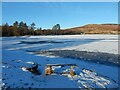
Carman Reservoir frozen over
by Lairich Rig geograph for square NS3778 In front of the embankment of the dam, a valve tower can be seen on the right:... (more)
|
|
Carman Reservoir frozen over
by Lairich Rig geograph for square NS3778 Carman Hill is in the background.
Compare NS3778 : Carman Reservoir frozen over, looking in a different... (more)
Tags:
landmark:Carman HillX
top:Derelict, DisusedX
type:GeographX
subject:IceX
former:Reservoir
top:Water ResourcesX
|
|
Old reservoir
by Lairich Rig geograph for square NS4582 The reservoir does not appear on the first-edition map (surveyed in 1860), but... (more)
Tags:
landmark:Ben LomondX
top:Derelict, DisusedX
type:GeographX
former:Reservoir
top:Water ResourcesX
|
|
Old reservoir: western end of dam wall
by Lairich Rig geograph for square NS4674 The 1:25000 map and the present photograph showing a burn flowing down the slope... (more)
Tags:
top:Derelict, DisusedX
type:GeographX
former:Reservoir
top:Rivers, Streams, DrainageX
top:Water ResourcesX
|
|
Old reservoir: sluice gate
by Lairich Rig geograph for square NS4674 The Clyde is in the background.
Note the metal pipe leading obliquely down... (more)
|
|
Old reservoir: dam wall
by Lairich Rig geograph for square NS4674 Some way ahead is a sluice gate; for a closer view of it from the other side,... (more)
|
|
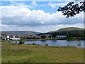
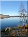
Lindean Reservoir
by Walter Baxter geograph for square NT5029 This was viewed on a fine but cold December afternoon when the reservoir was... (more)
|
|
Lindean Reservoir
by Walter Baxter geograph for square NT5029 This was viewed on a fine but cold December afternoon when the reservoir was... (more)
|
|
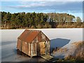
Lindean Reservoir Boathouse
by Walter Baxter geograph for square NT5029 This was viewed on a fine but cold December afternoon when the reservoir was... (more)
|
|
Garshake Reservoir
by Lairich Rig geograph for square NS4276 For further details, see another contributor's earlier photograph:... (more)
|
|
Stamford Park Boating Lake
by David Dixon geograph for square SJ9599 The boating lake to the north of Darnton Road. The lake, formerly the mill... (more)
Tags:
place:Ashton Under LyneX
IslandX
LakeX
top:Lakes, Wetland, BogX
ParkX
top:Park and Public GardensX
top:Public Buildings and SpacesX
former:Reservoir
top:Sport, LeisureX
Steam BoatX
top:Suburb, Urban FringeX
|
|
The Upper Lake, Stamford Park
by David Dixon geograph for square SJ9599 The former mill reservoir known as Chadwick Dams was incorporated into Stamford... (more)
Tags:
Angling ClubX
place:Ashton Under LyneX
top:Business, Retail, ServicesX
Fishing LodgeX
IslandX
LakeX
top:Lakes, Wetland, BogX
ParkX
top:Park and Public GardensX
former:Reservoir
place:StalybridgeX
top:Suburb, Urban FringeX
|

|
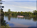
Stamford Park Boating Lake, The Stamford Belle
by David Dixon geograph for square SJ9599 The "Stamford Belle" steamer moored near the island in Stamford Park... (more)
Tags:
place:Ashton Under LyneX
IslandX
LakeX
top:Lakes, Wetland, BogX
ParkX
top:Park and Public GardensX
top:Public Buildings and SpacesX
former:Reservoir
top:Sport, LeisureX
Steam BoatX
top:Suburb, Urban FringeX
|