Public Tags
Tag: Heath·Burning
Showing images tagged with Heath Burning tag.
|
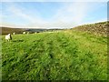
Footpath to Ankness
by Peter Holmes geograph for square SE6393 Public footpath 25.117/016 adjacent to a fine stone wall. Heath burning can be... (more)
Tags:
top:Farm, Fishery, Market GardeningX
type:GeographX
top:GrasslandX
Heath Burning
subject:PathX
top:PathsX
Public FootpathX
SheepX
top:Sport, LeisureX
Stone WallX
top:UplandsX
|
|
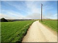
Farm Track to Bransdale Road
by Peter Holmes geograph for square SE6393 Public footpath 25.117/016 on farm track. Smoke from heath burning can be seen... (more)
Tags:
Electricity Power LineX
top:Farm, Fishery, Market GardeningX
type:GeographX
top:GrasslandX
Heath Burning
Public FootpathX
top:Roads, Road TransportX
subject:TrackX
top:UplandsX
|
|
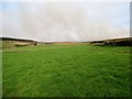
Fields north of Moor House Farm
by Peter Holmes geograph for square SE6395 With view of Scot Ridge to the left and smoke from heath burning to the right.
Tags:
top:Farm, Fishery, Market GardeningX
subject:FieldX
type:GeographX
top:GrasslandX
Heath Burning
Sheep GrazingX
Stone WallX
top:UplandsX
Wooded RidgeX
|