Geograph - photograph every grid square
About tags on Geograph
Tags
Geographical Context
Subjects
Types
Other Prefixes
Public Tags
Related Tags
|
Coverage Map
Tag:
Housing·Estate·Boundary
Showing images tagged with
Housing Estate Boundary
tag.
View all tagged images
-
In Browser
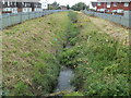
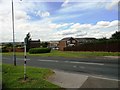
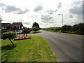
Reen is the boundary between two housing estates, Newport
by
Jaggery
geograph for square
ST3487
The view WSW along Liswerry Pill Reen, a drainage channel. On the left are... (
more
)
Tags:
top:
Boundary, Barrier
X
Housing Estate Boundary
Housing Estates
X
Reen
X
top:
Water Resources
X
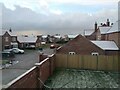
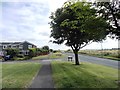
End of Reed Lane from house on Hodson Lane in Winter
by
Felix Brystal
geograph for square
TF0180
The south end of Reed Lane from a house on Hodson Lane on Beal Homes' new... (
more
)
Tags:
country:
England
X
place:
England
X
top:
Flat Landscapes
X
type:
Geograph
X
Houses
X
building type:
Houses
X
subject:
Houses
X
Houses for Sale Board
X
subject:
Housing
X
subject:
Housing Estate
X
building type:
Housing Estate
X
Housing Estate
X
Housing Estate Boundary
Housing Estates
X
top:
Housing, Dwellings
X
county:
Lincolnshire
X
place:
Lindsey
X
Residential
X
Residential Area
X
top:
Roads, Road Transport
X
Snow
X
subject:
Snow
X
weather:
Snow
X
Snowscene
X
weather:
Snowy
X
Snowy
X
top:
Suburb, Urban Fringe
X
Town
X
subject:
Village
X
Village
X
Village Street
X
top:
Village, Rural Settlement
X
place:
Welton
X
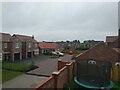
End of Reed Lane from house on Hodson Lane
by
Felix Brystal
geograph for square
TF0180
The south end of Reed Lane from a house on Hodson Lane on Beal Homes' new... (
more
)
Tags:
place:
England
X
country:
England
X
top:
Flat Landscapes
X
type:
Geograph
X
building type:
Houses
X
Houses
X
subject:
Houses
X
subject:
Housing
X
subject:
Housing Estate
X
Housing Estate
X
building type:
Housing Estate
X
Housing Estate Boundary
Housing Estates
X
top:
Housing, Dwellings
X
county:
Lincolnshire
X
place:
Lindsey
X
Residential
X
Residential Area
X
top:
Roads, Road Transport
X
top:
Suburb, Urban Fringe
X
top:
Village, Rural Settlement
X
place:
Welton
X
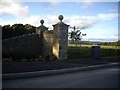
Road junction at Urpeth Grange
by
Robert Graham
geograph for square
NZ2454
This road forms the SW boundary of the large Urpeth Grange housing estate. The... (
more
)
Tags:
Housing Estate
X
Housing Estate Boundary
top:
Housing, Dwellings
X
Minor Road Junction
X
top:
Roads, Road Transport
X
top:
Village, Rural Settlement
X
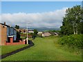
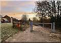
Start of the path to Perkinsville
by
Robert Graham
geograph for square
NZ2554
This footpath leads over the fields from the SW side of Urpeth Grange housing estate.
Tags:
Footpath Signpost
X
Housing Estate Boundary
Housing Estate Road
X
top:
Housing, Dwellings
X
top:
Lowlands
X
top:
Paths
X
Public Path
X
top:
Roads, Road Transport
X
Leyburn Close
by
Robert Graham
geograph for square
NZ2454
Street on the SW side of the large Urpeth Grange housing estate. The road here... (
more
)
Tags:
Housing Estate
X
Housing Estate Boundary
top:
Housing, Dwellings
X
top:
Lowlands
X
top:
Village, Rural Settlement
X
Gurnos Estate, Merthyr Tydfil
by
Robin Drayton
geograph for square
SO0408
A view looking west on the northern edge of this large estate.
Tags:
Housing Estate Boundary
top:
Housing, Dwellings
X
place:
Merthyr Tydfil
X
Entry to Burton Woods at Whitworth Park
by
Stanley Howe
geograph for square
NZ2433
A major housing development on the outskirts of Spennymoor.
Tags:
Housing Estate Boundary
Housing Estate Road
X
Spennymoor
X
top:
Suburb, Urban Fringe
X
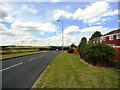
Road along the edge of Urpeth Grange
by
Robert Graham
geograph for square
NZ2554
This road runs along the western edge of the large housing estate of Urpeth... (
more
)
Tags:
Country Road
X
Housing Estate Boundary
top:
Housing, Dwellings
X
top:
Lowlands
X
Village Housing
X
top:
Village, Rural Settlement
X
Track up from old railway line
by
Jonathan Hutchins
geograph for square
SJ8146
This is the western end of National Cycle Route 551, marked by the small blue... (
more
)
Tags:
top:
Boundary, Barrier
X
Dog Waste Bin
X
type:
Geograph
X
Housing Estate Boundary
top:
Housing, Dwellings
X
stile:
Metal Post Squeeze
X
Metal Squeeze Stile
X
National Cycle Route
X
National Cycle Route 551
X
Path
X
top:
Paths
X
top:
Roads, Road Transport
X
subject:
Stile
X
View more in the Image Search
or
in Browser
View images matching 'Housing Estate Boundary' anywhere
in
the tags
Don't click these:
PotMel 1
PotMel 2
☰
Home
View
Search
Marked Images
Maps
Browser
Explore
Showcase
New Images
Collections
Interact
Games
Discussions
Blog
Contributors
Submit
Statistics
Leaderboards
General
FAQ
Help Pages
Sitemap
Contact Us
Support Us
sponsored by
🔍
What to search:
Photos
Enter keywords or a location/postcode to search nearby images
Enter a Grid Reference
Placenames
Collections
Website Pages
Everything
Others:
Advanced Search
|
Image Browser
Or:
Coverage Map
|
Searchable Map
You are not logged in
login
|
register