Public Tags
Tag: Inn·(Former)
Showing images tagged with Inn (Former) tag.
|
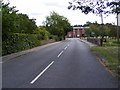
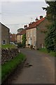
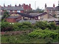
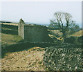
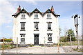
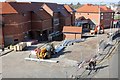
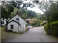
B1117 Halesworth Road at Walpole Bridge
by Geographer geograph for square TM3674 Category: B road (Classified B) Looking towards the junction with Peasenhall Road & the former Bell Inn
Tags:
B Road (Classified B)X
B1117X
B1117 Halesworth RoadX
Bell InnX
Bell Inn (Former)X
Halesworth RoadX
Inn (Former)
Peasenhall RoadX
Public House (Former)X
Road JunctionX
top:Roads, Road TransportX
The Bell Inn Public HouseX
The Bell Inn Public House (Former)X
at:WalpoleX
at:Walpole BridgeX
Walpole BridgeX
|
|
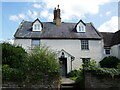
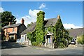
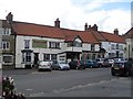
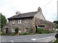
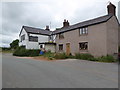
The Old Ship, Pilling
by Steven Haslington geograph for square SD4048 The Old Ship is a residential property in the village of Pilling, in Lancashire,... (more)
|
|
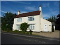
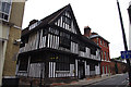
Former Ship Inn
by Richard Croft geograph for square SK8189 Grade II listed, 18th century, former Ship Inn in Silver Street in Gainsborough.
|
|
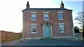
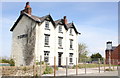
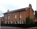
The former Bell Inn Public House
by Geographer geograph for square TM3973 On the A144 The Street near the junction with Church Farm Road
|
|
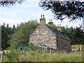
Former Inn
by Mick Garratt geograph for square SE8490 This has been a private house since 1932. Before that it was an inn known as the... (more)
Tags:
HouseX
top:Housing, DwellingsX
former:InnX
Inn (Former)
VillageX
top:Village, Rural SettlementX
|
|
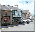
Greengrocery formerly The General Picton Inn, Nelson
by Jaggery geograph for square ST1195 The former Commercial Street inn is a now a fruit and veg shop, next door to the... (more)
|
|
Extension to the Old Angel Inn
by Jonathan Thacker geograph for square SP9555 Eighteenth century extension to the former inn. The bracket for the inn sign... (more)
|
|
The Poker Tree
by Mick Garratt geograph for square NN5200 So named after a fight between Bailie Nicol Jarvie, a magistrate from Glasgow,... (more)
Tags:
top:Historic Sites and ArtefactsX
former:HotelX
Inn (Former)
OakX
Oak TreeX
Old OakX
Old Oak TreeX
TreeX
top:Village, Rural SettlementX
|
|
Former Stanley Inn?
by Mike Kirby geograph for square SE3524 The old stone farm building was said to be a local inn, long before the present... (more)
Tags:
top:Farm, Fishery, Market GardeningX
Inn (Former)
|
|
The Old Angel Inn, Carlton
by Jonathan Thacker geograph for square SP9555 Seventeenth century former inn... (more)
|
|
The Old Ram Inn
by Richard Croft geograph for square TF3324 Former inn on High Road in Whaplode
|
|
The Greyhound
by Richard Croft geograph for square TF0733 Former coaching inn Link in Folkingham, now... (more)
|
|
Last gasp inn?
by Stephen Craven geograph for square SD9563 Category: Public house (disused) Another view of Lane Head SD9563 : Lane Head, which stands at the end of a bridleway from... (more)
|
|
Ship House, Clun
by Jeff Buck geograph for square SO3080 The 17th century, Grade II listed Ship House in Clun was at one time an inn. The... (more)
|
|
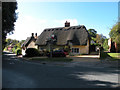
The Carrier, Elmdon
by Keith Edkins geograph for square TL4639 Formerly the Carrier Inn, now renovated but still has its inn sign and a Greene... (more)
Tags:
type:GeographX
Grade II Listed BuildingX
top:Housing, DwellingsX
Inn (Former)
roofing material:ThatchX
top:Village, Rural SettlementX
|
|
The Crown/Y Goron (closed), Ffynnongroyw
by Jeff Buck geograph for square SJ1382 The Crown Inn at Ffynnongroyw ceased trading in 2010 after the death of the... (more)
Tags:
top:Construction, DevelopmentX
Derelict BuildingX
Development SiteX
place:FfynnongroywX
county:FlintshireX
Former Mining VillageX
type:GeographX
Inn (Former)
Pub (Closed)X
top:Village, Rural SettlementX
country:WalesX
|
|
Y Goron/The Crown (closed), Ffynnongroyw
by Jeff Buck geograph for square SJ1382 The Crown Inn at Ffynnongroyw ceased trading in 2010 after the death of the... (more)
Tags:
top:Construction, DevelopmentX
Development SiteX
place:FfynnongroywX
county:FlintshireX
Former Mining VillageX
type:GeographX
Inn (Former)
Pub (Closed)X
top:Village, Rural SettlementX
country:WalesX
|
|
Former Perseverance Inn - Forge Lane
by Betty Longbottom geograph for square SE2319 |
|
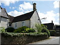
Black Lion House, Bishop's Castle
by Eirian Evans geograph for square SO3288 This large house on the junction of Welsh Street and Union Street was formerly... (more)
|
|
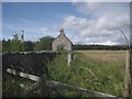
Cuttieshillock
by Stanley Howe geograph for square NO6491 Formerly an inn on the Cairn O'Mounth road.
Tags:
top:Historic Sites and ArtefactsX
Inn (Former)
|
|
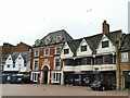
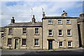
Nos 11, 13 &15, Market Place
by Mike Kirby geograph for square SE6986 A grade II listed inn, the former Black Swan Hotel, see SE6986 : Black Swan Inn, Market Place, Kirkbymoorside, is now a... (more)
|
|
Borezell, Llanwrda
by Jaggery geograph for square SN7131 Located on the east side of the A482, at the southern edge of the village... (more)
|
|
The Earl of Derby (former inn)
by David Smith geograph for square TQ2581 The name is inscribed on the facade at the top, on the third floor. Like many... (more)
|
|
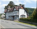
The Old White Horse, Worthen
by Bill Harrison geograph for square SJ3204 Dating from the early 19th Century, formerly an inn on the (now) B4386 but now... (more)
Tags:
road:B4386X
False WindowsX
Flemish BondX
type:GeographX
top:Housing, DwellingsX
Inn (Former)
building material:Red BrickX
top:Village, Rural SettlementX
|
|
The former Black Horse at Killington
by Stephen Craven geograph for square SD6291 The 19th century inn had already closed when it was listed grade II (list entry... (more)
|
|
Former Royal Oak Inn, Northgate Street
by Ian Taylor geograph for square TM1644 Now solicitors' offices, on the corner of Oak Lane. Grade I listed... (more)
|

|
Inscription on Earl of Derby (former inn)
by David Smith for square TQ2581 The building is shown in TQ2581 : The Earl of Derby (former inn)
|
|
The Green, Richmond
by Stephen Craven geograph for square NZ1600 Most of the 19th century houses lining two sides of the triangular green are... (more)
|
|
Site of the Watergate Inn, Chester
by Jeff Buck geograph for square SJ4066 The Watergate Inn has now been demolished to allow work to commence on the... (more)
Tags:
county:CheshireX
place:ChesterX
Chester City WallsX
Chester RacecourseX
top:Construction, DevelopmentX
Development SiteX
country:EnglandX
type:GeographX
Inn (Former)
Pub DemolishedX
|
|
Cerrigllwydion Arms, Llanynys
by Eirian Evans geograph for square SJ1062 The inn has been closed for many years and on my last visit, it looks like part... (more)
Tags:
top:Business, Retail, ServicesX
top:Housing, DwellingsX
subject:InnX
Inn (Former)
top:Village, Rural SettlementX
|
|
Iron Sign Farm
by Andrew Curtis geograph for square NZ1067 Taken from the same location as NZ1067 : Iron Sign Farm
Eppies Hill rises to the right... (more)
|
|
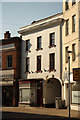
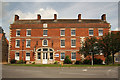
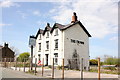
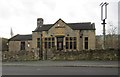
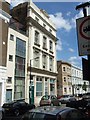
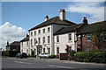
HSBC and Nationwide, Banbury Marketplace
by Stephen Craven geograph for square SP4540 The Nationwide occupies a grade II* listed 17th century inn (list entry 1369548).
|
|
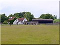
Crowsnest Dingle
by Bill Harrison geograph for square SJ3601 A Shropshire hamlet clinging to the side of Oak Hill. The white building in the... (more)
Tags:
type:GeographX
HamletX
Inn (Former)
Post BoxX
ShropshireX
top:UplandsX
top:Village, Rural SettlementX
|
|
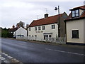
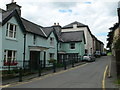
18th Century houses, Kirkgate, Settle
by Bill Harrison geograph for square SD8163 The house to the right was once an inn; the blue plaque commemorates the... (more)
Tags:
18th Century HousesX
Blue PlaqueX
top:City, Town CentreX
type:GeographX
top:Historic Sites and ArtefactsX
top:Housing, DwellingsX
Inn (Former)
building material:LimestoneX
|
|
Gable end, Cuttieshillock
by Stanley Howe geograph for square NO6491 |
|
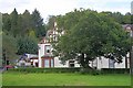
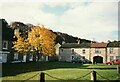
Scrooby Top House
by Richard Croft geograph for square SK6588 On the Old Great North Road, Scrooby Top House was built in 1780 by Thomas... (more)
|