Public Tags
Showing images tagged with long distance footpath:Dales Way tag.
|
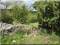
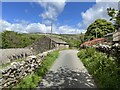
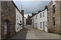
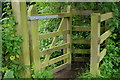
Footpath gate near Tommy Bridge
by Adrian Taylor geograph for square SD7286 The gate is on the route of the Dales Way long distance path.
Tags:
top:Boundary, BarrierX
Dales Way
ldp:Dales Way
long distance footpath:Dales Way
long distance path:Dales Way
place:DentdaleX
FootpathX
Footpath GateX
subject:GateX
type:GeographX
top:PathsX
Public FootpathX
Public Footpath GateX
The Dales WayX
footpath gate:WoodenX
Yorkshire Dales National ParkX
|
|
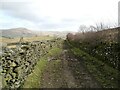
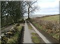
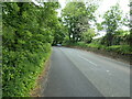
Lane near Goodham Scales
by Adrian Taylor geograph for square SD5497 This lane is the route of The Dales Way long distance path from... (more)
Tags:
CumbriaX
long distance path:Dales Way
ldp:Dales Way
long distance footpath:Dales Way
Dales Way
type:GeographX
subject:LaneX
Long Distance PathX
top:Roads, Road TransportX
Route of Long Distance PathX
The Dales WayX
TrackX
|
|
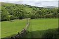
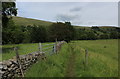
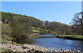
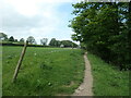
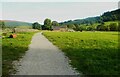
Dales Way near Appletreewick
by Chris Heaton geograph for square SE0559 Fine section of the long distance footpath between Howgill and Burnsall.... (more)
|
|
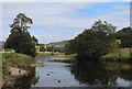
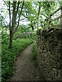
Dales Way between Howgill and Burnsall
by Chris Heaton geograph for square SE0559 The long distance footpath near Appletreewick
|
|
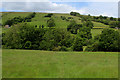
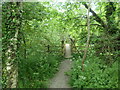
Dales Way near Hadfield Farm
by Chris Heaton geograph for square SE1048 The long distance footpath about a mile from its eastern terminus at the Old... (more)
|
|
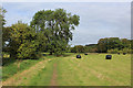
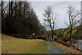
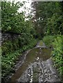
Dales Way descending towards Tommy Bridge
by Chris Heaton geograph for square SD7286 The long distance footpath in the pastoral scene of Dentdale
Tags:
DaleX
long distance footpath:Dales Way
Dry Stone WallX
type:GeographX
MeadowsX
Pastoral SceneX
top:PathsX
Public FootpathX
|
|
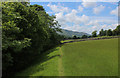
Dales Way crossing a Meadow to reach the River Dee
by Chris Heaton geograph for square SD7386 The long distance footpath on the valley floor of Dentdale
|
|
Dales Way heading West down Dentdale
by Chris Heaton geograph for square SD7386 The long distance footpath takes to the northern side of the River Dee - but... (more)
|
|
Ewegales
by Adrian Taylor geograph for square SD7586 The minor road is the route of the Dales Way long distance path.
Tags:
ldp:Dales Way
long distance footpath:Dales Way
long distance path:Dales Way
Dales Way
place:DentdaleX
type:GeographX
subject:RoadX
top:Roads, Road TransportX
The Dales WayX
top:Village, Rural SettlementX
Yorkshire Dales National ParkX
|
|
Garnett Folds Lane at Chester Hag
by Adrian Taylor geograph for square SD5396 This minor road is the route of The Dales Way long distance path from Woodhouse... (more)
Tags:
CumbriaX
long distance path:Dales Way
ldp:Dales Way
long distance footpath:Dales Way
Dales Way
type:GeographX
Minor RoadX
road:Minor RoadX
subject:RoadX
top:Roads, Road TransportX
The Dales WayX
|
|
Dales Way running through Lythe Plantation
by Chris Heaton geograph for square SE0162 Section of the long distance footpath between Hebden and Linton Falls
|
|
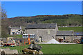
Haugh Mill Farm
by Chris Heaton geograph for square SE0559 Farm beside the River Wharfe, and passed by the Dales Way long distance footpath.
|
|
Dales Way East of Church Bridge
by Chris Heaton geograph for square SD7187 The Dales Way long distance footpath between Church Bridge and Mill Bridge,... (more)
|
|
Dales Way near Hebden
by Chris Heaton geograph for square SE0262 The long distance footpath upstream from the Hebden Suspension Bridge
|
|
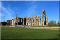
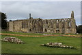
Bolton Priory under a Blue Winter Sky
by Chris Heaton geograph for square SE0754 Augustinian Priory beside the River Wharfe, and passed by the Dales Way long... (more)
Tags:
long distance footpath:Dales Way
type:GeographX
Grade I Listed BuildingX
Parish ChurchX
Priory RuinsX
top:Religious SitesX
|
|
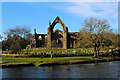
Bolton Priory from across the River Wharfe
by Chris Heaton geograph for square SE0754 Augustinian Priory beside the River Wharfe, and passed by the Dales Way long... (more)
Tags:
long distance footpath:Dales Way
type:GeographX
Grade I Listed BuildingX
Parish ChurchX
Priory RuinsX
top:Religious SitesX
RiverX
|
|
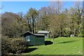
Green Chalets by Haugh Mill Farm
by Chris Heaton geograph for square SE0559 These two cabins have been here for years, located at the point where Fir Beck... (more)
Tags:
ChaletsX
long distance footpath:Dales Way
type:GeographX
Green CabinsX
top:Housing, DwellingsX
|
|
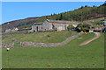
Gamsworth Farm
by Chris Heaton geograph for square SE0558 Farming operation seen from the Dales Way long distance footpath, beside the River Wharfe
|
|
Bolton Priory
by Chris Heaton geograph for square SE0754 Augustinian Priory beside the River Wharfe, and passed by the Dales Way long... (more)
Tags:
Augustinian PrioryX
long distance footpath:Dales Way
type:GeographX
Grade I Listed BuildingX
Parish ChurchX
Priory RuinsX
top:Religious SitesX
|
|
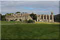
Dales Way approaching Bolton Priory from the South
by Chris Heaton geograph for square SE0754 One of the highlights of this long distance footpath in the section around the... (more)
Tags:
Augustinian PrioryX
long distance footpath:Dales Way
type:GeographX
Grade II Listed BuildingX
Historical SiteX
Parish ChurchX
Priory RuinsX
top:Religious SitesX
|
|
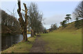
River Wharfe heading towards Bolton Priory
by Chris Heaton geograph for square SE0753 Following the Dales Way long distance footpath through the Bolton Abbey Estate,... (more)
|
|
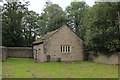
Farfield Friends Meeting House
by Chris Heaton geograph for square SE0751 This quaker meeting house was built in 1689 by Anthony Myers of Farfield Hall in... (more)
Tags:
long distance footpath:Dales Way
type:GeographX
Historic SiteX
Quaker Meeting HouseX
top:Religious SitesX
|
|
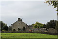
Farfield Cottages
by Chris Heaton geograph for square SE0751 As seen from the Dales Way long distance footpath approaching the B6160... (more)
|
|
Dales Way North of Addingham
by Chris Heaton geograph for square SE0850 The long distance footpath heading north after passing through Olicana Caravan Park.
|
|
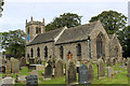
St. Peter's Church, Addingham
by Chris Heaton geograph for square SE0849 Christian worship has taken place on this site since 700AD or possibly even... (more)
|
|
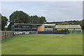
Ilkley Lawn Tennis and Squash Club
by Chris Heaton geograph for square SE1048 The clubhouse seen from the Dales Way long distance footpath which passes... (more)
|
|
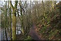
Dales Way in Haugh Wood
by Chris Heaton geograph for square SE0559 |
|
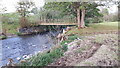
Footbridge over the River Mint
by Rich Tea geograph for square SD5696 Carrying the Dales Way long distance footpath.
Looking downstream.
|
|
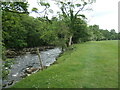
River Wharfe North of Barden Bridge
by Chris Heaton geograph for square SE0558 Looking downstream
Tags:
long distance footpath:Dales Way
type:GeographX
RiverX
River SceneX
top:Rivers, Streams, DrainageX
|
|
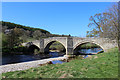
Barden Bridge
by Chris Heaton geograph for square SE0557 Three arched hump backed bridge spanning the River Wharfe below Barden Tower.... (more)
Tags:
BridgeX
long distance footpath:Dales Way
type:GeographX
Grade II Listed BuildingX
top:Historic Sites and ArtefactsX
RiverX
River SceneX
|
|
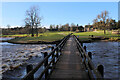
Footbridge across the River Wharfe, Bolton Abbey
by Chris Heaton geograph for square SE0754 Substantial wooden bridge takes the Dales Way across the River Wharfe, opposite... (more)
|
|
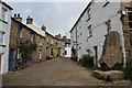
Main Street, Dent
by Chris Heaton geograph for square SD7086 Probably the best preserved of all Yorkshire Dales Villages, despite being in... (more)
Tags:
Cobbled StreetX
Commemoration StoneX
Dales VillageX
long distance footpath:Dales Way
DwellingsX
type:GeographX
Village SceneX
top:Village, Rural SettlementX
|
|
On Main Street, Dent
by Chris Heaton geograph for square SD7087 Probably the best preserved of all Yorkshire Dales Villages, despite being in... (more)
Tags:
Cobbled StreetX
Dales VillageX
long distance footpath:Dales Way
type:GeographX
Main StreetX
VillageX
top:Village, Rural SettlementX
|
|
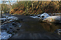
A Ford over Pickles Gill Beck
by Chris Heaton for square SE0855 Ford near the Cavendish Cafe.
It can be found on the minor road that runs... (more)
Tags:
BeckX
type:Cross GridX
long distance footpath:Dales Way
FordX
LaneX
top:Rivers, Streams, DrainageX
Winter SceneX
|
|
Farm Track, Shaw End, Patton Bridge
by Rich Tea for square SD5596 The Dales Way follows this track for a short distance, and goes through a... (more)
Tags:
type:Cross GridX
Dales Way
long distance path:Dales Way
long distance footpath:Dales Way
top:Farm, Fishery, Market GardeningX
place:Patton BridgeX
Patton BridgeX
place:Shaw EndX
subject:TrackX
|
|
Dales Way signpost, Patton Bridge, Cumbria
by Rich Tea for square SD5597 Looking across the road from Meal Bank (right) to Patton Bridge (left).
Tags:
type:Close LookX
long distance path:Dales Way
long distance footpath:Dales Way
Dales Way
Patton BridgeX
place:Patton BridgeX
subject:SignpostX
top:Village, Rural SettlementX
|
|
Lane at Shaw End, Patton Bridge
by Rich Tea geograph for square SD5597 Passing the walled garden. The Dales Way joins this lane a little further on,... (more)
Tags:
top:Country EstatesX
long distance footpath:Dales Way
long distance path:Dales Way
type:GeographX
subject:LaneX
place:Patton BridgeX
place:Shaw EndX
top:Village, Rural SettlementX
Walled Kitchen GardenX
|
|
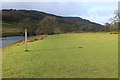
The west bank of the River Wharfe
by Christine Johnstone geograph for square SE0851 The field edge public footpath forms part of the Dales Way. The river forms the... (more)
|
|
The former route of the Dales Way, near Lob Wood
by Christine Johnstone geograph for square SE0752 Unknown to the photographer, this section of the long distance path on the B6160... (more)
|
|
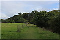
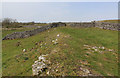
A very wide section of the Dales Way footpath, Hartlington
by Humphrey Bolton geograph for square SE0360 A generous width, securely fenced.
|
|
The Dales Way, above the River Wharfe
by Christine Johnstone geograph for square SE0751 Looking north.
|
|
The Dales Way, by Fairfield Cottages
by Christine Johnstone geograph for square SE0751 Skirting round a garden on the west bank of the River Wharfe, just in West Yorkshire.
|
|
Public footpath crossing Hambleton Beck
by Christine Johnstone geograph for square SE0752 Taking the Dales Way away from the busy B6160.
Tags:
long distance footpath:Dales Way
FootbridgeX
Footbridge Over BeckX
path:FootpathX
type:GeographX
subject:PathX
top:PathsX
Public FootpathX
|

|
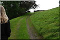
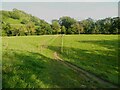
Field near Shaw End, Patton Bridge
by Rich Tea geograph for square SD5596 Looking towards Shaw End, from the Dales Way path.
Tags:
long distance footpath:Dales Way
Dales Way
top:Farm, Fishery, Market GardeningX
subject:FieldX
type:GeographX
Patton BridgeX
place:Patton BridgeX
place:Shaw EndX
top:Village, Rural SettlementX
|
|
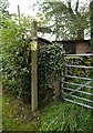
Kissing gate between 2 farm tracks, Shaw End, Patton Bridge
by Rich Tea for square SD5597 The Dales Way goes through this gate.
Tags:
type:Close LookX
long distance footpath:Dales Way
Dales Way
top:Farm, Fishery, Market GardeningX
gate:Kissing GateX
Kissing GateX
Kissing GatesX
place:Patton BridgeX
place:Shaw EndX
|
|
The Dales Way eastwards from Woodhouse, Appletreewick
by Humphrey Bolton geograph for square SE0460 A broad track of broken stone, the vehicle access to Water's Lathe.
|
|
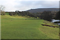
Dales Way approaching Lea Green
by Chris Heaton geograph for square SD9965 |