Public Tags
Other tags: Speyside Way
long distance path:Speyside Way
Showing latest 50 of 292 images tagged with long distance footpath:Speyside Way tag.
|
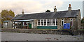
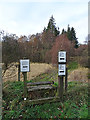
Nethy Bridge Railway Station
by Anne Burgess geograph for square NJ0020 The former Strathspey Railway station is right beside the Speyside Way... (more)
Tags:
type:GeographX
top:PathsX
top:RailwaysX
long distance footpath:Speyside Way
Speyside WayX
long distance path:Speyside Way
|
|
A Walker on the Speyside Way
by Anne Burgess geograph for square NJ0326 Maybe it is because it is November, but we saw only four other people on the... (more)
Tags:
type:GeographX
top:PathsX
top:RailwaysX
long distance path:Speyside Way
Speyside WayX
long distance footpath:Speyside Way
Strathspey RailwayX
railway:Strathspey RailwayX
|
|
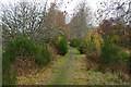
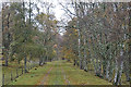
Speyside Way at Achnagonalin
by Anne Burgess geograph for square NJ0326 The Speyside Way, using the trackbed of the former Strathspey Railway, skirts... (more)
Tags:
type:GeographX
top:PathsX
top:RailwaysX
long distance footpath:Speyside Way
long distance path:Speyside Way
Speyside WayX
Strathspey RailwayX
railway:Strathspey RailwayX
|
|
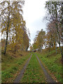
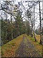
Speyside Way
by Anne Burgess geograph for square NJ0225 The trackbed of the former Strathspey Railway, now the route of the Speyside... (more)
Tags:
top:Farm, Fishery, Market GardeningX
type:GeographX
top:PathsX
top:RailwaysX
Speyside WayX
long distance footpath:Speyside Way
long distance path:Speyside Way
railway:Strathspey RailwayX
Strathspey RailwayX
top:Woodland, ForestX
|
|
Speyside Way
by Anne Burgess geograph for square NJ0225 Although still using the trackbed of the Strathspey Railway, the path here is... (more)
Tags:
type:GeographX
top:PathsX
top:RailwaysX
long distance path:Speyside Way
Speyside WayX
long distance footpath:Speyside Way
Strathspey RailwayX
railway:Strathspey RailwayX
top:Woodland, ForestX
|
|
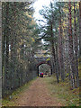
Speyside Way
by Anne Burgess geograph for square NJ0225 The Speyside Way follows the trackbed of the former Strathspey Railway between... (more)
Tags:
type:GeographX
top:PathsX
top:RailwaysX
Speyside WayX
long distance footpath:Speyside Way
long distance path:Speyside Way
railway:Strathspey RailwayX
Strathspey RailwayX
top:Woodland, ForestX
|
|
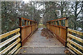
Speyside Way Footbridge
by Anne Burgess geograph for square NJ0224 The smart new bridge on the Speyside Way closes a gap where the Strathspey... (more)
Tags:
type:GeographX
top:PathsX
top:RailwaysX
long distance path:Speyside Way
long distance footpath:Speyside Way
Strathspey RailwayX
railway:Strathspey RailwayX
top:Woodland, ForestX
|
|
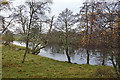
A Glimpse of the River Spey
by Anne Burgess geograph for square NJ0224 This is the first time on this section of the Speyside Way that the route gets... (more)
Tags:
type:GeographX
top:PathsX
top:RailwaysX
top:Rivers, Streams, DrainageX
Speyside WayX
long distance footpath:Speyside Way
long distance path:Speyside Way
railway:Strathspey RailwayX
Strathspey RailwayX
top:Woodland, ForestX
|
|
Strathspey Railway Trackbed
by Anne Burgess geograph for square NJ0224 The trackbed of the former Strathspey Railway is now part of the Speyside Way.
Tags:
type:GeographX
top:PathsX
top:RailwaysX
long distance path:Speyside Way
Speyside WayX
long distance footpath:Speyside Way
Strathspey RailwayX
railway:Strathspey RailwayX
top:Woodland, ForestX
|
|
Speyside Way Waymark
by Anne Burgess for square NJ0124 The waymarker indicates where the Backham Trail, and alternative route to both... (more)
Tags:
type:Close LookX
top:PathsX
top:RailwaysX
Speyside WayX
long distance footpath:Speyside Way
long distance path:Speyside Way
Strathspey RailwayX
railway:Strathspey RailwayX
top:Woodland, ForestX
|
|
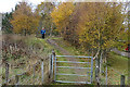
Bridge near Boat of Ballifurth
by Anne Burgess geograph for square NJ0124 The bridge carries the access road to Boat of Balliefurth over the trackbed of... (more)
Tags:
type:GeographX
top:PathsX
top:RailwaysX
top:Roads, Road TransportX
Speyside WayX
long distance footpath:Speyside Way
long distance path:Speyside Way
railway:Strathspey RailwayX
Strathspey RailwayX
top:Woodland, ForestX
|
|
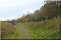
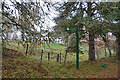
Embankment at Balliefurth Farm
by Anne Burgess geograph for square NJ0123 At Balliefurth the Speyside Way is briefly diverted off the former Strathspey... (more)
Tags:
top:Farm, Fishery, Market GardeningX
type:GeographX
top:Geological InterestX
top:PathsX
top:RailwaysX
long distance path:Speyside Way
Speyside WayX
long distance footpath:Speyside Way
Strathspey RailwayX
railway:Strathspey RailwayX
|
|
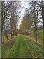
Speyside Way
by Anne Burgess geograph for square NJ0022 The Speyside Way follows the trackbed of the Strathspey Railway from Nethy... (more)
Tags:
type:GeographX
top:PathsX
top:RailwaysX
Speyside WayX
long distance footpath:Speyside Way
long distance path:Speyside Way
railway:Strathspey RailwayX
Strathspey RailwayX
top:Woodland, ForestX
|
|
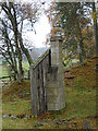
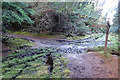
Chimney Gable
by Anne Burgess for square NJ0023 At first glance this looks like the gable end of a wooden hut with a stone... (more)
Tags:
type:Close LookX
top:Derelict, DisusedX
top:PathsX
top:RailwaysX
long distance path:Speyside Way
Speyside WayX
long distance footpath:Speyside Way
Strathspey RailwayX
railway:Strathspey RailwayX
top:Woodland, ForestX
|
|
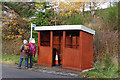
When's the Next Bus?
by Anne Burgess geograph for square NJ1835 Maybe some time next year if you're really lucky. There is a bus timetable... (more)
Tags:
type:GeographX
top:PathsX
top:Roads, Road TransportX
Speyside WayX
long distance path:Speyside Way
long distance footpath:Speyside Way
top:UplandsX
|
|
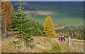
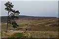
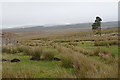
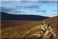
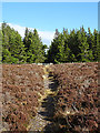
On the Tomintoul Spur of the Speyside Way
by Anne Burgess geograph for square NJ1827 The path at this point is rather indistinct compared with the rest of the route,... (more)
Tags:
top:Farm, Fishery, Market GardeningX
type:GeographX
top:PathsX
long distance footpath:Speyside Way
Speyside WayX
long distance path:Speyside Way
top:UplandsX
top:Woodland, ForestX
|
|
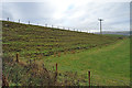
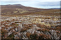
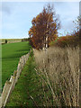
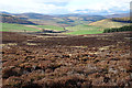
A Long Fence
by Anne Burgess geograph for square NJ1827 Many of the fences shown on the maps along the Tomintoul Spur of the Speyside... (more)
Tags:
type:GeographX
top:MoorlandX
top:PathsX
long distance footpath:Speyside Way
Speyside WayX
long distance path:Speyside Way
top:UplandsX
|
|
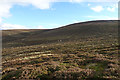
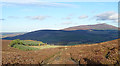
Tom a' Chor from Cairn Daimh
by Anne Burgess for square NJ1624 The map shows the Tomintoul Spur of the Speyside Way following a track that... (more)
Tags:
type:Cross GridX
top:Farm, Fishery, Market GardeningX
top:MoorlandX
top:PathsX
long distance footpath:Speyside Way
Speyside WayX
long distance path:Speyside Way
top:UplandsX
top:Woodland, ForestX
|
|
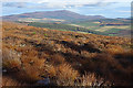
The Buck and The Bochel
by Anne Burgess for square NJ2323 The Buck of Cabrach is the hill just peeking up above the ridge in the distance,... (more)
Tags:
type:Cross GridX
top:MoorlandX
top:PathsX
long distance footpath:Speyside Way
Speyside WayX
long distance path:Speyside Way
top:UplandsX
|
|
Heading for Cairn Ellick
by Anne Burgess geograph for square NJ1721 The Tomintoul Spur of the Speyside Way follows the fence on the left, then... (more)
Tags:
type:GeographX
top:MoorlandX
top:PathsX
long distance footpath:Speyside Way
Speyside WayX
long distance path:Speyside Way
top:UplandsX
|
|
Between Fences
by Anne Burgess geograph for square NJ1721 Following the Tomintoul Spur of the Speyside Way, one comes to this open area... (more)
Tags:
type:GeographX
top:Lakes, Wetland, BogX
top:PathsX
Speyside WayX
long distance path:Speyside Way
long distance footpath:Speyside Way
top:UplandsX
|
|
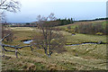
Conglass Water
by Anne Burgess for square NJ1619 From the slope above the right bank, there is a good view of one of the meanders... (more)
Tags:
type:Cross GridX
top:PathsX
top:Rivers, Streams, DrainageX
long distance path:Speyside Way
long distance footpath:Speyside Way
Speyside WayX
top:UplandsX
|
|
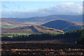
Looking towards Ben Rinnes
by Anne Burgess geograph for square NJ2033 As you start on the downhill part of this section of the Tomintoul Spur of the... (more)
Tags:
type:GeographX
top:MoorlandX
top:PathsX
Speyside WayX
long distance path:Speyside Way
long distance footpath:Speyside Way
top:Sport, LeisureX
top:UplandsX
|
|
|
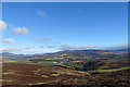
'Panorama' from Hill of Deskie
by Anne Burgess geograph for square NJ1931 It's not a real panorama because it is not a full 360º view, but only about... (more)
Tags:
type:GeographX
top:MoorlandX
top:PathsX
Speyside WayX
long distance path:Speyside Way
long distance footpath:Speyside Way
top:UplandsX
|
|
|
'Panorama' from above Deskie
by Anne Burgess for square NJ1930 It isn't a real panorama, of course, because it is not a full 360º view,... (more)
Tags:
type:Cross GridX
top:Farm, Fishery, Market GardeningX
top:PathsX
Speyside WayX
long distance path:Speyside Way
long distance footpath:Speyside Way
top:UplandsX
|
|
Tomintoul Spur of the Speyside Way
by Anne Burgess geograph for square NJ2030 The Tomintoul Spur of the Speyside Way Link
Tags:
top:Farm, Fishery, Market GardeningX
type:GeographX
top:PathsX
long distance footpath:Speyside Way
Speyside WayX
long distance path:Speyside Way
top:UplandsX
|
|
Speyside Way Diversion
by Anne Burgess geograph for square NJ2029 The maps show the Tomintoul Spur of the Speyside Way... (more)
Tags:
type:GeographX
top:PathsX
long distance footpath:Speyside Way
Speyside WayX
long distance path:Speyside Way
top:UplandsX
|
|
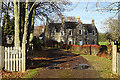
Glenlivet House
by Anne Burgess geograph for square NJ1928 I remember this better as Blairfindy Lodge Hotel, which was a comfortable... (more)
Tags:
top:Business, Retail, ServicesX
type:GeographX
long distance footpath:Speyside Way
Speyside WayX
long distance path:Speyside Way
top:UplandsX
|
|
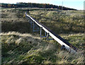
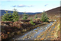
Wooden Flume
by Anne Burgess geograph for square NJ1828 This miniature aqueduct beide the Tomintoul Spur of the Speyside Way carries... (more)
Tags:
type:GeographX
top:PathsX
long distance footpath:Speyside Way
Speyside WayX
long distance path:Speyside Way
top:UplandsX
top:Water ResourcesX
|
|
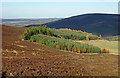
Plantation above Blairfindy
by Anne Burgess geograph for square NJ1827 The Tomintoul Spur of the Speyside Way enters the plantation at the gate at... (more)
Tags:
type:GeographX
top:MoorlandX
top:PathsX
long distance footpath:Speyside Way
Speyside WayX
long distance path:Speyside Way
top:UplandsX
top:Woodland, ForestX
|
|
Tomintoul Spur of the Speyside Way
by Anne Burgess geograph for square NJ1827 At this point the path begins to descend towards the fields and woods at... (more)
Tags:
type:GeographX
top:MoorlandX
top:PathsX
long distance footpath:Speyside Way
Speyside WayX
long distance path:Speyside Way
top:UplandsX
top:Woodland, ForestX
|
|
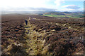
On the Tomintoul Spur of the Speyside Way
by Anne Burgess geograph for square NJ1827 The path is following the contour round the lower slope of Carn Liath, with a... (more)
Tags:
type:GeographX
top:MoorlandX
top:PathsX
Speyside WayX
long distance path:Speyside Way
long distance footpath:Speyside Way
top:UplandsX
|
|
Tomintoul Spur of the Speyside Way
by Anne Burgess geograph for square NJ1826 The path here follows the contour round the shoulder of Carn Liath. It was... (more)
Tags:
type:GeographX
top:MoorlandX
top:PathsX
top:Roads, Road TransportX
long distance footpath:Speyside Way
Speyside WayX
long distance path:Speyside Way
top:UplandsX
|
|
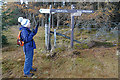
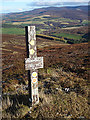
A Plethora of Signs
by Anne Burgess for square NJ1825 The older, brown wooden signs mark the junction of Tomintoul Spur of the... (more)
Tags:
type:Close LookX
top:PathsX
Speyside WayX
long distance path:Speyside Way
long distance footpath:Speyside Way
top:UplandsX
top:Woodland, ForestX
|
|
Glenlivet Bike Trails
by Anne Burgess geograph for square NJ1825 We presume that the reason why the Tomintoul Spur of the Speyside Way now... (more)
Tags:
type:GeographX
top:MoorlandX
top:PathsX
long distance footpath:Speyside Way
Speyside WayX
long distance path:Speyside Way
top:Sport, LeisureX
top:UplandsX
top:Woodland, ForestX
|
|
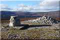
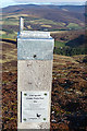
Toposcope and Summit Cairn
by Anne Burgess geograph for square NJ1824 The toposcope or view indicator and cairn stand together on the highest point of... (more)
Tags:
type:GeographX
top:MoorlandX
top:PathsX
Speyside WayX
long distance path:Speyside Way
long distance footpath:Speyside Way
top:UplandsX
|
|
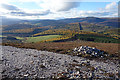
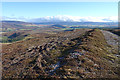
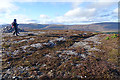
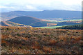
Looking South-east from Cairn Daimh
by Anne Burgess geograph for square NJ1824 The path on the right is the Tomintoul Spur of the Speyside Way. To its left The... (more)
Tags:
type:GeographX
top:MoorlandX
top:PathsX
Speyside WayX
long distance path:Speyside Way
long distance footpath:Speyside Way
top:UplandsX
|
|
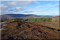
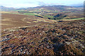
Looking North from Cairn Daimh
by Anne Burgess for square NJ1825 The Tomintoul Spur of the Speyside Way follows the line of the fence down to... (more)
Tags:
type:Cross GridX
top:MoorlandX
top:PathsX
long distance footpath:Speyside Way
Speyside WayX
long distance path:Speyside Way
top:UplandsX
top:Woodland, ForestX
|
|
Summit of Carn Daimh
by Anne Burgess geograph for square NJ1824 Montane tundra and short vegetation characterise the summit of Carn Daimh on the... (more)
Tags:
top:Barren PlateauxX
type:GeographX
top:PathsX
long distance path:Speyside Way
long distance footpath:Speyside Way
Speyside WayX
top:UplandsX
|
|
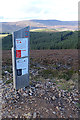
Carn Daimh Summit Marker
by Anne Burgess geograph for square NJ1824 The post isn't quite on the summit, which is occupied by a cairn and view... (more)
Tags:
type:GeographX
top:MoorlandX
top:PathsX
long distance footpath:Speyside Way
Speyside WayX
long distance path:Speyside Way
top:UplandsX
|
|
Not the Official Photo
by Anne Burgess for square NJ2828 This was not taken with the camera sitting in the bracket on top of... (more)
Tags:
type:Cross GridX
top:MoorlandX
top:PathsX
long distance footpath:Speyside Way
Speyside WayX
long distance path:Speyside Way
top:UplandsX
|
|
The Official View
by Anne Burgess for square NJ2828 This was taken with the camera sitting in the bracket on top of NJ1824 : Scenic Photo Post.... (more)
Tags:
type:Cross GridX
top:MoorlandX
top:PathsX
Speyside WayX
long distance path:Speyside Way
long distance footpath:Speyside Way
top:UplandsX
|
|
Scenic Photo Post
by Anne Burgess geograph for square NJ1824 Several of these posts have been erected at scenic places in the Cairngorms... (more)
Tags:
type:GeographX
top:MoorlandX
top:PathsX
long distance footpath:Speyside Way
Speyside WayX
long distance path:Speyside Way
top:UplandsX
|
|
The Bochel and Braes of Glenlivet
by Anne Burgess for square NJ2323 The Bochel is the dark rounded heather-clad hill towards the left, and the Braes... (more)
Tags:
type:Cross GridX
top:MoorlandX
top:PathsX
long distance footpath:Speyside Way
Speyside WayX
long distance path:Speyside Way
top:UplandsX
top:Woodland, ForestX
|
|
Ben Rinnes
by Anne Burgess for square NJ2535 After the mud and gloom inside the forest on the Tomintoul Spur of the Speyside... (more)
Tags:
p150 hill:Ben RinnesX
Ben RinnesX
type:Cross GridX
top:Farm, Fishery, Market GardeningX
top:MoorlandX
top:PathsX
long distance footpath:Speyside Way
Speyside WayX
long distance path:Speyside Way
top:UplandsX
|
|
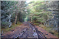
Muddy Forest Track
by Anne Burgess geograph for square NJ1823 Some parts of the Tomintoul Spur of the Speyside Way in the forest on Cairn... (more)
Tags:
type:GeographX
top:PathsX
long distance footpath:Speyside Way
Speyside WayX
long distance path:Speyside Way
top:Woodland, ForestX
|
|
A Guttery Junction
by Anne Burgess geograph for square NJ1923 'Guttery' is a Scots word for something that is muddier than just... (more)
Tags:
type:GeographX
top:PathsX
top:Roads, Road TransportX
Speyside WayX
long distance path:Speyside Way
long distance footpath:Speyside Way
top:UplandsX
top:Woodland, ForestX
|
|
Approaching the Gate
by Anne Burgess geograph for square NJ1823 At the gate ahead, the Tomintoul Spur of the Speyside Way enters the forest on... (more)
Tags:
type:GeographX
top:MoorlandX
top:PathsX
Speyside WayX
long distance path:Speyside Way
long distance footpath:Speyside Way
top:UplandsX
top:Woodland, ForestX
|
|
Walkers on the Tomintoul Spur of the Speyside Way
by Anne Burgess geograph for square NJ1823 Normally I lag behind my companions taking photographs, and I don't like... (more)
Tags:
type:GeographX
top:MoorlandX
top:PathsX
long distance footpath:Speyside Way
Speyside WayX
long distance path:Speyside Way
top:UplandsX
|
|
Allt Ellick
by Anne Burgess geograph for square NJ1822 Allt is Gaelic for a burn or small river, but you would be hard put to see... (more)
Tags:
top:Farm, Fishery, Market GardeningX
type:GeographX
top:MoorlandX
top:PathsX
Speyside WayX
long distance path:Speyside Way
long distance footpath:Speyside Way
top:UplandsX
|