Public Tags
Other tags: Great Glen Way
Showing latest 50 of 324 images tagged with long distance path:Great Glen Way tag.
|
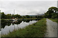
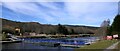
Pontoon on the Caledonian Canal
by Bill Kasman geograph for square NN1076 This yacht is berthed at a pontoon on the section of the canal between Corpach... (more)
Tags:
Caledonian CanalX
top:CanalsX
top:Docks, HarboursX
type:GeographX
Great Glen Way
long distance path:Great Glen Way
top:PathsX
top:Sport, LeisureX
|
|
Start of the Great Glen Way, at the old fort
by Craig Wallace geograph for square NN1074 This stone pillar marks the start or end of the Great Glen Way, a long distance... (more)
Tags:
ruin:FortX
place:Fort WilliamX
long distance path:Great Glen Way
top:Historic Sites and ArtefactsX
top:Park and Public GardensX
top:PathsX
top:Suburb, Urban FringeX
|
|
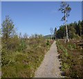
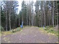
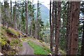
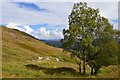
Great Glen Way crossing moorland, near Blackfold
by Craig Wallace geograph for square NH5840 Here the Great Glen Way follows a small path across rather windswept moorland.... (more)
|
|
Great Glen Way and minor road, by Altourie
by Craig Wallace geograph for square NH5639 After following the minor road for several kilometres from near Abriachan, here... (more)
Tags:
long distance path:Great Glen Way
Minor Road and Path JunctionX
top:MoorlandX
top:PathsX
top:Roads, Road TransportX
|
|
Pontoon across the Caledonian Canal, Cullochy Lock, Inverness-shire
by Claire Pegrum geograph for square NH3404 A section of The Great Glen Way has been temporarily diverted while works are... (more)
Tags:
top:CanalsX
type:GeographX
long distance path:Great Glen Way
Long Distance Cycle RouteX
Long Distance PathX
top:PathsX
subject:PontoonX
|
|
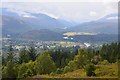
Fort Augustus and the Caledonian Canal
by Jim Barton for square NH3708 An extensive view back to Fort Augustus and its surroundings from the high level... (more)
Tags:
type:Cross GridX
Great GlenX
long distance path:Great Glen Way
top:Lakes, Wetland, BogX
top:Rivers, Streams, DrainageX
top:UplandsX
View Down ValleyX
top:Village, Rural SettlementX
|
|
Rejoining the Great Glen Way at Clunes
by Jim Barton geograph for square NN2088 After the detour via Achnacarry, the Great Glen Way is met for the long stretch... (more)
Tags:
Forest TrackX
type:GeographX
long distance path:Great Glen Way
top:PathsX
top:Roads, Road TransportX
Waymark PostX
top:Woodland, ForestX
|
|
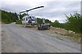
Helicopter by the Great Glen Way, near Portclair
by Craig Wallace geograph for square NH4013 An unexpected sight on this forest track, some distance from the nearest road.... (more)
Tags:
top:Air TransportX
top:Construction, DevelopmentX
Forest TrackX
long distance path:Great Glen Way
HelicopterX
top:Roads, Road TransportX
top:Woodland, ForestX
|
|
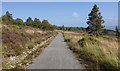
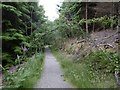
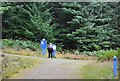
Great Glen Way, near Abriachan
by Craig Wallace geograph for square NH5436 Here the Great Glen Way follows a little path through mixed woodland. This is a... (more)
|
|
New looking path, Ruskich Wood
by Richard Webb geograph for square NH4823 Thanks to this recently resurfaced path, the height loss and regain on the Great... (more)
|
|
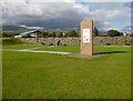
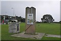
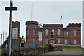
Southwestern end of the Great Glen Way, Fort William
by Jim Barton geograph for square NN1074 A Caithness flagstone monument on the site of the old fort, marking the SW end... (more)
Tags:
top:Defence, MilitaryX
top:Derelict, DisusedX
type:GeographX
long distance path:Great Glen Way
top:Historic Sites and ArtefactsX
MonumentX
top:PathsX
Site of a FortX
|
|
On the Great Glen Way by Loch Oich
by Jim Barton geograph for square NH3100 The old railway route has been upgraded to a wide long-distance path, part of... (more)
Tags:
top:Derelict, DisusedX
Former Railway RouteX
type:GeographX
long distance path:Great Glen Way
top:PathsX
top:RailwaysX
|
|
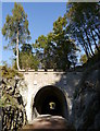
Old railway tunnel, by Loch Oich
by Craig Wallace geograph for square NH3302 This tunnel was part of the Invergarry & Fort Augustus Railway, probably the... (more)
Tags:
Bat BoxX
Former Railway TunnelX
long distance path:Great Glen Way
railway:Invergarry and Fort Augustus RailwayX
top:PathsX
top:RailwaysX
national cycle network:Route 78X
TunnelX
top:Woodland, ForestX
|
|
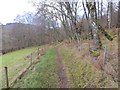
Fenced in path, Tychat
by Richard Webb geograph for square NH5330 The Great Glen Way makes an effort to stay of the road here, which is unusual... (more)
Tags:
top:Farm, Fishery, Market GardeningX
long distance path:Great Glen Way
top:PathsX
top:Woodland, ForestX
|
|
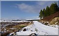
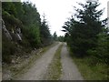
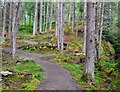
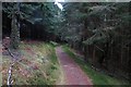
Forest track, by Achpopuli
by Craig Wallace geograph for square NH5334 A snow-covered track passing through the edge of Abriachan Forest. This is part... (more)
Tags:
Abriachan ForestX
Forest TrackX
long distance path:Great Glen Way
top:Roads, Road TransportX
SnowX
top:Woodland, ForestX
|
|
Great Glen Way
by Richard Webb geograph for square NH5026 A path beside the road to Balbeg and Grotaig which is used by the Great Glen Way.
|
|
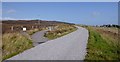
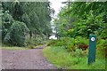
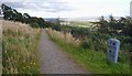
Road end
by Richard Webb geograph for square NH5431 The end of the logging road that runs above Loch Ness from Abriachan. The blue... (more)
|
|
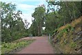
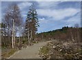
Great Glen Way high route, above Invermoriston
by Craig Wallace geograph for square NH4217 Part of the new Great Glen Way "high route". This path has been built... (more)
|
|
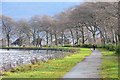
Caledonian Canal
by Jim Barton geograph for square NN1278 The track alongside the canal is used as part of the Great Glen Way long... (more)
|
|
Great Glen Way, heading down the slopes of Craig Dunain
by Craig Wallace geograph for square NH6344 The Great Glen Way follows a path past a reservoir, then heads down through... (more)
Tags:
Craig DunainX
GaidhligX
top:GrasslandX
long distance path:Great Glen Way
top:PathsX
top:Woodland, ForestX
|
|
Great Glen Way, near Altourie
by Craig Wallace geograph for square NH5740 Here the Great Glen Way follows a path across the moor, mostly running parallel... (more)
Tags:
top:Energy InfrastructureX
long distance path:Great Glen Way
top:MoorlandX
top:PathsX
Wind TurbineX
|
|
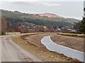
Caledonian Canal approaching Fort Augustus
by valenta geograph for square NH3608 The canal has been dewatered while the lock gates at Fort Augustus and Kyltra... (more)
Tags:
canal:Caledonian CanalX
subject:CanalX
top:CanalsX
Dewatered CanalX
type:GeographX
long distance path:Great Glen Way
top:LowlandsX
top:PathsX
top:Rivers, Streams, DrainageX
top:Sport, LeisureX
|
|
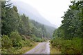
Big climb on the Great Glen Way
by Richard Webb geograph for square NH4620 The long haul up the side of the Great Glen between Alltsaigh and Grotaig.
Tags:
type:GeographX
long distance path:Great Glen Way
top:Roads, Road TransportX
top:Rocks, Scree, CliffsX
top:Woodland, ForestX
|
|
Great Glen Way
by Richard Webb geograph for square NH4116 Descent into Glen Morriston after a long period contouring on a forest road... (more)
|
|
End of the Great Glen Way at Inverness Castle
by Jim Barton geograph for square NH6645 Journey's end for Great Glen Wayfarers: the Caithness flagstone monument to... (more)
Tags:
top:City, Town CentreX
type:GeographX
long distance path:Great Glen Way
top:Historic Sites and ArtefactsX
Inverness CastleX
top:PathsX
|
|
Great Glen Way sign in suburban Inverness
by Jim Barton geograph for square NH6444 The routes for the Great Glen Way, Caledonian Canal and City Centre and Kinmylies.
Tags:
Footpath SignpostsX
type:GeographX
long distance path:Great Glen Way
top:PathsX
top:Suburb, Urban FringeX
|
|
Entrance to Great Glen House, Inverness
by Jim Barton geograph for square NH6344 The headquarters of Scottish Natural Heritage and other bodies - and,... (more)
Tags:
Entrance SignX
type:GeographX
long distance path:Great Glen Way
top:PathsX
top:Public Buildings and SpacesX
top:Suburb, Urban FringeX
|
|
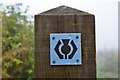
Great Glen Way waymark
by Jim Barton for square NH6243 The generic thistle path waymark on a pale blue background marks the Great Glen... (more)
|
|
Steep descent to Invermoriston
by Jim Barton geograph for square NH4215 The cunningly built path winds down some steep ground in the plantation - the... (more)
Tags:
Forest PathX
type:GeographX
long distance path:Great Glen Way
top:PathsX
Trees on HillsideX
top:UplandsX
top:Woodland, ForestX
|
|
New path by the Allt na Criche
by Jim Barton geograph for square NH3811 The path, not shown on the 1:25,000 map, is on the Great Glen Way high level... (more)
Tags:
Forest PathX
type:GeographX
long distance path:Great Glen Way
top:PathsX
top:Woodland, ForestX
|
|
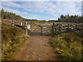
Great Glen Way through cleared forest, by Blackfold
by Craig Wallace geograph for square NH5940 The Great Glen Way goes through this gate, into an area of cleared forest. It... (more)
|
|
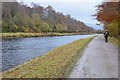
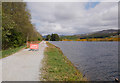
Great Glen Way by the Caledonian Canal
by Jim Barton geograph for square NN1076 The Great Glen Way follows the canal for several miles on the route to Inverness.
|
|
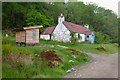
Abandoned cottage, Letirfearn
by Craig Wallace geograph for square NH3201 An old cottage, close to the south shore of Loch Oich.
The Great Glen Way... (more)
Tags:
Abandoned CottageX
listed building:Category CX
top:Derelict, DisusedX
long distance path:Great Glen Way
top:Housing, DwellingsX
top:PathsX
ToiletX
top:Woodland, ForestX
|
|
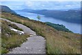
Loch Ness from the high level route
by Jim Barton geograph for square NH3912 The size of the loch can be appreciated from this high viewpoint on the Great Glen Way.
Tags:
type:GeographX
Grass and Heather MoorlandX
Great GlenX
long distance path:Great Glen Way
top:Lakes, Wetland, BogX
top:MoorlandX
top:PathsX
top:UplandsX
View of Loch NessX
|
|
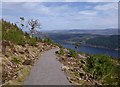
Path descending, in Creag nan Eun Forest
by Craig Wallace geograph for square NH4520 This is part of the Great Glen Way high route, it looks like this path has been... (more)
Tags:
long distance path:Great Glen Way
top:PathsX
tree:Scots PineX
View of Loch NessX
top:Woodland, ForestX
|
|
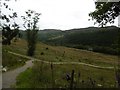
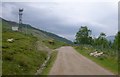
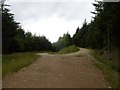
Great Glen Way following track, near Kilfinnan
by Craig Wallace geograph for square NN2795 The Great Glen Way follows tracks through the forest by Loch Lochy, then to... (more)
Tags:
top:CommunicationsX
top:Farm, Fishery, Market GardeningX
long distance path:Great Glen Way
MastX
MastsX
top:Roads, Road TransportX
|
|
Hairpin bend, Creag-nan-Eun Forest
by Richard Webb geograph for square NH4620 The Great Glen Way uses the road to gain height above Loch Ness. It's a long way up.
Tags:
type:GeographX
long distance path:Great Glen Way
top:Roads, Road TransportX
top:Woodland, ForestX
|
|
Great Glen Way by Loch Lochy
by Jim Barton geograph for square NN2189 On the long stretch by forest track to the north end of the loch and Laggan.
Tags:
Forest TrackX
type:GeographX
long distance path:Great Glen Way
top:PathsX
top:Roads, Road TransportX
Trees on HillsideX
top:Woodland, ForestX
|
|
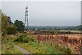
Great Glen Way on the edge of Inverness
by Jim Barton geograph for square NH6443 Earthmoving machinery was at work on the land to the right with the Way... (more)
Tags:
top:Construction, DevelopmentX
top:Energy InfrastructureX
FarmlandX
type:GeographX
long distance path:Great Glen Way
Overhead Power LinesX
top:PathsX
top:Suburb, Urban FringeX
|
|
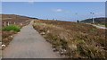
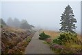
Great Glen Way above Easter Altourie
by Jim Barton geograph for square NH5840 A misty day on the final leg of the Way to Inverness. Note that the route here... (more)
Tags:
top:Air, Sky, WeatherX
type:GeographX
long distance path:Great Glen Way
Heather and Grass MoorlandX
MistX
top:MoorlandX
top:PathsX
top:UplandsX
|

|
Great Glen Way above Invermoriston
by Jim Barton geograph for square NH4217 Both low and high level options for the Way leave the tarmac here.
Tags:
type:GeographX
long distance path:Great Glen Way
Minor Road and Path JunctionX
top:PathsX
top:Roads, Road TransportX
Waymark PostX
top:Woodland, ForestX
|
|
Path above the Portclair Burn
by Jim Barton geograph for square NH4014 The Great Glen Way descends a short way here before taking an undulating line to... (more)
|
|
Choice of routes on the Great Glen Way
by Jim Barton geograph for square NH3810 The Way splits here into high and low level options between Fort Augustus and... (more)
Tags:
Forest PathX
type:GeographX
long distance path:Great Glen Way
Information BoardX
top:PathsX
Waymark PostX
top:Woodland, ForestX
|
|
Great Glen Way leaving Fort Augustus
by Jim Barton geograph for square NH3810 The Way takes a minor road above the A82 before branching left here to follow... (more)
Tags:
type:GeographX
long distance path:Great Glen Way
top:PathsX
Road and Path JunctionX
Waymark PostX
|
|
Great Glen Way
by Richard Webb geograph for square NH5330 Not sure if this path predates the way or not. It makes a steep descent from... (more)
|
|
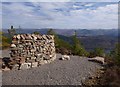
Stone shelter, on the Great Glen Way high route
by Craig Wallace geograph for square NH4519 This is probably the highest point on the path, at an elevation of about 420m.... (more)
|
|
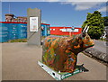
Heilan Coo, Inverness Castle
by Craig Wallace geograph for square NH6644 A cow sculpture off View Place, in front of the castle. This design is... (more)
Tags:
top:City, Town CentreX
type:GeographX
long distance path:Great Glen Way
Great Heilan Coo TrailX
top:Historic Sites and ArtefactsX
place:InvernessX
Inverness CastleX
artwork:SculptureX
|
|
Caledonian Canal towards Kytra
by Craig Wallace geograph for square NH3406 The path on the left is part of the Great Glen Way and NCN Route 78. It looks... (more)
|
|
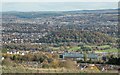
View from the Great Glen Way
by valenta for square NH6343 Fine views over Inverness City, Great Glen House in the lower right. Above that... (more)
Tags:
type:Cross GridX
long distance path:Great Glen Way
top:Housing, DwellingsX
place:InvernessX
top:LowlandsX
top:Suburb, Urban FringeX
subject:ViewX
top:Woodland, ForestX
|
|
Great Glen Way
by Richard Webb geograph for square NH3303 Passing the northern end of Loch Oich on a purpose built path.
|