Geograph - photograph every grid square
About tags on Geograph
Tags
Geographical Context
Subjects
Types
Other Prefixes
Public Tags
Related Tags
|
Coverage Map
Tag:
Marlborough
Other tags:
near:
Marlborough
place:
Marlborough
Showing images tagged with
Marlborough
tag.
View all tagged images
-
In Browser
Search within these images
:
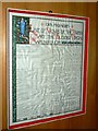
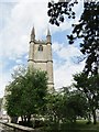
List of vicars, St Marys Church, Marlborough
by
Brian Robert Marshall
for square
SU1869
Category: Church
The list carries the names of the incumbents from 1316 to 1991. Some very... (
more
)
Tags:
top:
City, Town Centre
X
List
X
Marlborough
top:
Religious Sites
X
Vicars
X
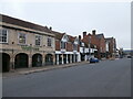
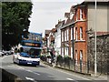
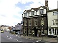
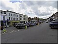
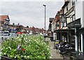
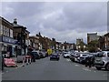
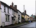
Marlborough High Street
by
HelenK
geograph for square
SU1869
The street is lined on both sides with shops of a kind to indicate the high... (
more
)
Tags:
road:
A4
X
top:
City, Town Centre
X
Estate Agent
X
type:
Geograph
X
Jewellers
X
place:
Marlborough
X
top:
Roads, Road Transport
X
Supermarket
X
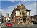
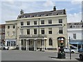
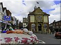
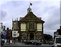
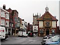
Marlborough - Town Hall
by
Colin Smith
geograph for square
SU1869
The gem of an historic Town Hall dominates the east end of Marlborough High... (
more
)
Tags:
top:
City, Town Centre
X
type:
Geograph
X
High Street
X
top:
Historic Sites and Artefacts
X
place:
Marlborough
X
Town Hall
X
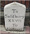
Marlborough - Milestone
by
Colin Smith
for square
SU1869
Historic stone by Marlborough's old town hall. This was once on the main... (
more
)
Tags:
type:
Close Look
X
place:
Marlborough
X
subject:
Milepost or Milestone
X
Milestone
X
top:
Roads, Road Transport
X
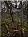
Footpath to Chopping Knife Lane Marlborough
by
Gillie Rhodes
geograph for square
SU2068
Start of the Footpath to Chopping Knife Lane Marlborough. Just off the A4 London... (
more
)
Tags:
Chopping Knife
X
Footpath
X
top:
Lowlands
X
place:
Marlborough
X
top:
Paths
X
Sign
X
Stile
X
top:
Woodland, Forest
X
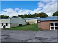
Elmtree Park
by
HelenK
geograph for square
SU1669
This is variously known as Elmtree Park, Elmtree Industrial Park and Elmtree... (
more
)
Tags:
top:
Business, Retail, Services
X
place:
Fyfield
X
type:
Geograph
X
Industrial Estate
X
place:
Manton
X
place:
Marlborough
X
top:
Village, Rural Settlement
X
firm:
Water Treatment
X
SW end of Marlborough High Street
by
HelenK
geograph for square
SU1868
At this end of the High Street can be found Marlborough Library... (
more
)
Tags:
Arts Centre
X
top:
Business, Retail, Services
X
former:
Church (Church of England)
X
top:
City, Town Centre
X
type:
Geograph
X
place:
Marlborough
X
top:
Public Buildings and Spaces
X
Public House
X
Public Library
X
top:
Religious Sites
X
top:
Roads, Road Transport
X
Social Distancing Barrier
X
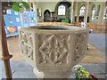
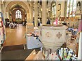
Marlborough - St Mary's Font
by
Colin Smith
for square
SU1869
Within the parish church located at the east end of Marlborough High Street.
Tags:
subject:
Font
X
top:
Historic Sites and Artefacts
X
type:
Inside
X
place:
Marlborough
X
top:
Religious Sites
X
church:
St Mary
X
Marlborough - Ailesbury Court
by
Colin Smith
geograph for square
SU1869
Historic building on Marlborough's High Street.
Link
Tags:
top:
City, Town Centre
X
type:
Geograph
X
High Street
X
subject:
Historic Building
X
top:
Historic Sites and Artefacts
X
place:
Marlborough
X
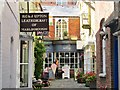
Marlborough - Local Shops
by
Colin Smith
for square
SU1869
A leathercraft and a sweet shop in a quiet pend off Marlborough's historic... (
more
)
Tags:
top:
Business, Retail, Services
X
top:
City, Town Centre
X
type:
Cross Grid
X
subject:
Lane
X
place:
Marlborough
X
Shops
X
Marlborough - St Peter and St Paul Church
by
Colin Smith
geograph for square
SU1868
The now redundant Church of St Peter and St Paul at the west end of... (
more
)
Tags:
subject:
Church
X
type:
Geograph
X
top:
Historic Sites and Artefacts
X
place:
Marlborough
X
top:
Religious Sites
X
church:
St Peter and St Paul
X
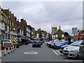
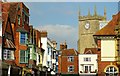
Marlborough - High Street
by
Colin Smith
geograph for square
SU1868
Stagecoach bus 80 on its way to Tidworth leaving the west end of... (
more
)
Tags:
subject:
Bus
X
top:
City, Town Centre
X
type:
Geograph
X
High Street
X
place:
Marlborough
X
top:
Roads, Road Transport
X
The High Street in Marlborough from Hilliers Yard
by
Steve Daniels
geograph for square
SU1869
Tags:
Archway
X
type:
Geograph
X
road:
High Street
X
place:
Marlborough
X
top:
Roads, Road Transport
X
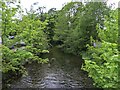
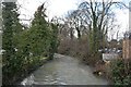
The River Kennet in Marlborough
by
Steve Daniels
geograph for square
SU1868
Tags:
type:
Geograph
X
place:
Marlborough
X
River Kennet
X
top:
Rivers, Streams, Drainage
X
The River Kennet in Marlborough
by
Steve Daniels
geograph for square
SU1868
Tags:
type:
Geograph
X
place:
Marlborough
X
River Kennet
X
top:
Rivers, Streams, Drainage
X
The River Kennet in Marlborough
by
Steve Daniels
geograph for square
SU1868
Tags:
type:
Geograph
X
place:
Marlborough
X
River Kennet
X
top:
Rivers, Streams, Drainage
X
The Bear at Marlborough on Oxford Street
by
Steve Daniels
geograph for square
SU1869
Tags:
road:
A4
X
top:
Business, Retail, Services
X
type:
Geograph
X
place:
Marlborough
X
Public House
X
top:
Roads, Road Transport
X
High Street in Marlborough
by
Steve Daniels
geograph for square
SU1869
Tags:
top:
City, Town Centre
X
type:
Geograph
X
road:
High Street
X
place:
Marlborough
X
top:
Roads, Road Transport
X
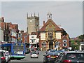
The Town Hall on High Street in Marlborough
by
Steve Daniels
geograph for square
SU1869
The yarn bombers have covered the postbox.
Tags:
top:
City, Town Centre
X
type:
Geograph
X
road:
High Street
X
place:
Marlborough
X
top:
Public Buildings and Spaces
X
Town Hall
X
High Street in Marlborough
by
Steve Daniels
geograph for square
SU1868
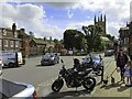
Tags:
Church
X
top:
City, Town Centre
X
type:
Geograph
X
road:
High Street
X
place:
Marlborough
X
Motorcycles
X
top:
Roads, Road Transport
X
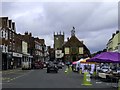
Marlborough - High Street
by
Colin Smith
geograph for square
SU1869
St Mary's Church and the Town Hall dominate the wide High Street, an... (
more
)
Tags:
Church
X
top:
City, Town Centre
X
type:
Geograph
X
High Street
X
place:
Marlborough
X
subject:
Street
X
Town Hall
X
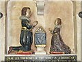
Marlborough - Sir Nicholas Hyde White Memorial
by
Colin Smith
for square
SU1868
Colourful painted memorial within the redundant Church of St Peter and St Paul.... (
more
)
Tags:
type:
Close Look
X
top:
Historic Sites and Artefacts
X
type:
Inside
X
place:
Marlborough
X
subject:
Memorial
X
church:
St Peter and St Paul
X
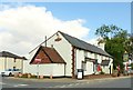
Marlborough - Redundant St Peter and St Paul Church
by
Colin Smith
for square
SU1868
The Church of St Peter and St Paul at the west end of the High Street dates from... (
more
)
Tags:
subject:
Church Interior
X
Font
X
top:
Historic Sites and Artefacts
X
type:
Inside
X
place:
Marlborough
X
top:
Religious Sites
X
church:
St Peter and St Paul
X
Marlborough - High Street
by
Colin Smith
geograph for square
SU1868
This long and wide street made an obvious marketplace. Today it is still busy... (
more
)
Tags:
top:
City, Town Centre
X
type:
Geograph
X
High Street
X
place:
Marlborough
X
subject:
Street
X
London Road passes the Roebuck in Marlborough
by
Steve Daniels
geograph for square
SU1969
Tags:
road:
A Road
X
top:
Business, Retail, Services
X
type:
Geograph
X
place:
Marlborough
X
Public House
X
top:
Roads, Road Transport
X
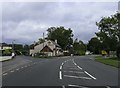
London Road in Marlborough
by
Steve Daniels
geograph for square
SU1969
Tags:
road:
A Road
X
type:
Geograph
X
Houses
X
place:
Marlborough
X
top:
Roads, Road Transport
X
The Town Hall in Marlborough
by
Steve Daniels
geograph for square
SU1869
Tags:
type:
Geograph
X
place:
Marlborough
X
top:
Public Buildings and Spaces
X
Town Hall
X
High Street in Marlborough
by
Steve Daniels
geograph for square
SU1869
Tags:
top:
City, Town Centre
X
type:
Geograph
X
street:
High Street
X
place:
Marlborough
X
top:
Roads, Road Transport
X
High Street in Marlborough
by
Steve Daniels
geograph for square
SU1869
Tags:
top:
City, Town Centre
X
type:
Geograph
X
street:
High Street
X
place:
Marlborough
X
top:
Roads, Road Transport
X
High Street in Marlborough
by
Steve Daniels
geograph for square
SU1868
Tags:
top:
City, Town Centre
X
type:
Geograph
X
street:
High Street
X
place:
Marlborough
X
top:
Roads, Road Transport
X
Shops
X
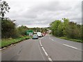
A346 View
by
Gordon Griffiths
geograph for square
SU1968
The view of the A346 Salisbury Road towards Marlborough.
Tags:
road:
A Road
X
type:
Geograph
X
place:
Marlborough
X
subject:
Road
X
top:
Roads, Road Transport
X
Traffic Queue
X
county:
Wiltshire
X
Perrins Hill, Marlborough
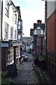
by
John Myers
geograph for square
SU1869
Alley behind the Town Hall
Tags:
Alley
X
subject:
Alleyway
X
top:
Business, Retail, Services
X
top:
City, Town Centre
X
type:
Geograph
X
top:
Lowlands
X
Marlborough
top:
Paths
X
Above the shops, Marlborough
by
nick macneill
for square
SU1869
Tags:
Church Tower
X
top:
City, Town Centre
X
place:
Marlborough
X
subject:
Town
X
Roebuck Inn, Marlborough
by
nick macneill
geograph for square
SU1969
Tags:
top:
Business, Retail, Services
X
place:
Marlborough
X
Public House
X
subject:
Public House
X
top:
Suburb, Urban Fringe
X
High Street, Marlborough
by
nick macneill
geograph for square
SU1869
Tags:
top:
City, Town Centre
X
place:
Marlborough
X
top:
Roads, Road Transport
X
Town Hall
X
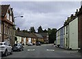
Houses in Herd Street, Marlborough
by
nick macneill
geograph for square
SU1869
Tags:
top:
City, Town Centre
X
top:
Housing, Dwellings
X
place:
Marlborough
X
top:
Roads, Road Transport
X
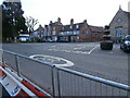
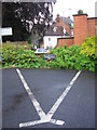
A triangular parking space
by
HelenK
geograph for square
SU1969
Pity the Marlborough motorist. Not only is he or she offered the fuel prices at... (
more
)
Tags:
top:
Business, Retail, Services
X
top:
City, Town Centre
X
Hedge
X
place:
Marlborough
X
Parking Bay
X
Wall
X
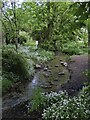
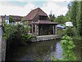
The Mustard Seed Cafe by the River Kennet
by
Steve Daniels
geograph for square
SU1868
Tags:
top:
Business, Retail, Services
X
Cafe
X
type:
Geograph
X
place:
Marlborough
X
River Kennet
X
top:
Rivers, Streams, Drainage
X
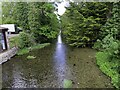
River Kennet
by
John Myers
geograph for square
SU1868
Upstream from the car park bridge
Tags:
top:
City, Town Centre
X
type:
Geograph
X
top:
Lowlands
X
Marlborough
subject:
River
X
River Kennet
X
top:
Rivers, Streams, Drainage
X
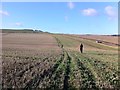
Beating at Temple Farm close to the Wootton Bassett road
by
James Harrison
geograph for square
SU1573
This view shows a line of beaters working one of the pheasant shoots at Temple... (
more
)
Tags:
Arable Countryside
X
Beating
X
top:
Country Estates
X
top:
Farm, Fishery, Market Gardening
X
Field
X
top:
Lowlands
X
near:
Marlborough
top:
People, Events
X
top:
Roads, Road Transport
X
Shooting
X
place:
Wiltshire
X
View more in the Image Search
or
in Browser
View images matching 'Marlborough' anywhere
in
the tags
Don't click these:
PotMel 1
PotMel 2
☰
Home
View
Search
Marked Images
Maps
Browser
Explore
Showcase
New Images
Collections
Interact
Games
Discussions
Blog
Contributors
Submit
Statistics
Leaderboards
General
FAQ
Help Pages
Sitemap
Contact Us
Support Us
sponsored by
🔍
What to search:
Photos
Enter keywords or a location/postcode to search nearby images
Enter a Grid Reference
Placenames
Collections
Website Pages
Everything
Others:
Advanced Search
|
Image Browser
Or:
Coverage Map
|
Searchable Map
You are not logged in
login
|
register