Public Tags
Tag: Minor·Rocks
Showing images tagged with Minor Rocks tag.
|
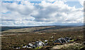
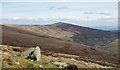
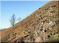
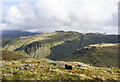
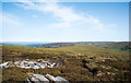
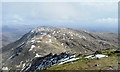
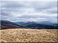
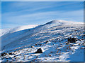
Rocks close to summit on Acton Moor
by Trevor Littlewood geograph for square NY8052 Minor outcropping rock close to the 515 m. high point at Acton Moor which might... (more)
Tags:
type:GeographX
Heather MoorlandX
Minor Rocks
top:MoorlandX
subject:RockX
top:Rocks, Scree, CliffsX
top:UplandsX
|
|
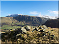
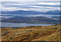
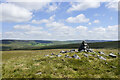
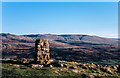
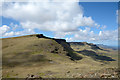
Summit rocks of Low Rigg
by Trevor Littlewood geograph for square NY3022 The summit rocks of the minor rise, Low Rigg, with Clough Head and Great Dodd... (more)
Tags:
type:GeographX
Hill Summit AreaX
Minor Rocks
subject:RockX
top:Rocks, Scree, CliffsX
top:UplandsX
|
|
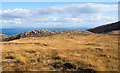
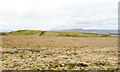
Rock-topped rib south of Am Màm
by Trevor Littlewood geograph for square NR4257 Am Màm is a minor feature, a rocky rise between the higher peaks, Glas Bheinn... (more)
Tags:
type:GeographX
Grassy MoorlandX
subject:KnollX
KnollX
Minor Rocks
top:MoorlandX
top:Rocks, Scree, CliffsX
top:UplandsX
|
|
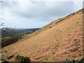
Slope with minor rocks on Creag na Saobhie
by Trevor Littlewood geograph for square NH0123 Creag na Saobhie is a north-eastern top of the Munro, A' Ghlas-bheinn; at... (more)
|
|
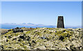
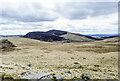
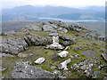
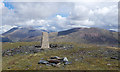
Summit area of Stob Odhar
by Trevor Littlewood geograph for square NR8174 A trig point marks the summit of Stob Odhar, there are minor rocks too.
In the... (more)
Tags:
type:GeographX
Hill Summit AreaX
top:Historic Sites and ArtefactsX
Minor Rocks
Trig PointX
top:UplandsX
|
|
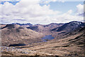
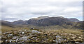
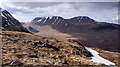
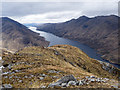
Slope descending from Beinn Bhreac
by Trevor Littlewood geograph for square NM9940 The slope is descending north-west to where the distant view is of the... (more)
|
|
Summit area of Meall Feith Dhiongaig
by Trevor Littlewood geograph for square NH2677 Meall Feith Dhiongaig is a minor hill top which certain hill-goers regard as a... (more)
Tags:
CairnX
type:GeographX
Hill Summit AreaX
Minor Rocks
top:Rocks, Scree, CliffsX
subject:SummitX
top:UplandsX
|
|
Rocks at Creag Dubh with ridge rising to summit of Blath Bhalg
by Trevor Littlewood geograph for square NO0260 The exposed rocks are at Creag Dubh which is an outlying top of Blath Bhalg the... (more)
Tags:
top:Air, Sky, WeatherX
type:GeographX
Minor Rocks
MistX
Mountain RidgeX
subject:RidgeX
top:Rocks, Scree, CliffsX
top:UplandsX
|
|
Rocks outcropping on Pike
by Trevor Littlewood geograph for square NY3031 Pike is a location along the broad, mainly heathery ridge rising out of the... (more)
Tags:
type:GeographX
Minor Rocks
Mountain SlopeX
subject:RockX
top:Rocks, Scree, CliffsX
top:UplandsX
|
|
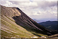
South-east face of Glamaig
by Trevor Littlewood geograph for square NG5129 Partly vegetated screes and low-angled rocks falling steeply from the ridge... (more)
|
|
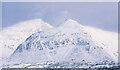
Thinly snowed summit plateau of Sgùrr na Feartaig
by Trevor Littlewood geograph for square NH0545 Snow lying on rocks at the summit of Sgùrr na Feartaig with Sgùrr Choinnich the... (more)
Tags:
top:Air, Sky, WeatherX
type:GeographX
Minor Rocks
Mountain Summit AreaX
top:Rocks, Scree, CliffsX
Snow CoverX
subject:SummitX
top:UplandsX
|
|
Cairn and rocks between Long Man and Long Hill
by Trevor Littlewood geograph for square NY9542 Long Hill and Long Man are two hills on the watershed separating the valleys of... (more)
Tags:
CairnX
subject:CairnX
type:GeographX
Grassy MoorlandX
Minor Rocks
top:MoorlandX
top:Rocks, Scree, CliffsX
top:UplandsX
|
|
Rocks on steep hillside
by Trevor Littlewood geograph for square NY2726 The slope, seen across Applethwaite Gill, rises almost unremittingly to Skiddaw... (more)
|
|
Hill slope with rocks and snow patch
by Trevor Littlewood geograph for square NN2646 The location is the north-east ridge of Beinn Toaig, a subsidiary top of Stob... (more)
|
|
Summit area of Largo Law
by Trevor Littlewood geograph for square NO4204 Largo Law is a hill of modest height on the north side of the Firth of Forth.
|
|
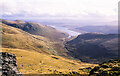
Slope descending towards Nest of Fannich
by Trevor Littlewood geograph for square NH1371 The slope is descending from high on the Munro, A' Chailleach, towards the... (more)
Tags:
type:GeographX
GlenX
Minor Rocks
Mountain SlopesX
top:Rivers, Streams, DrainageX
top:Rocks, Scree, CliffsX
top:UplandsX
|
|
Slope with sheep above Mitchell Cove
by Trevor Littlewood geograph for square NY2110 The foreground slope curves down to the right into the shallow hollow of... (more)
Tags:
top:Farm, Fishery, Market GardeningX
type:GeographX
Minor Rocks
Mountain SlopesX
top:Rocks, Scree, CliffsX
SheepX
top:UplandsX
|
|
Grassy slope of south side of Duchray Hill
by Trevor Littlewood geograph for square NO1666 Gentle grassy slopes descend towards the col between Duchray Hill and Mount... (more)
Tags:
type:GeographX
Grassy Hill SlopeX
Minor Rocks
top:Rocks, Scree, CliffsX
subject:SlopeX
top:UplandsX
|

|
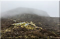
Thinly snowed ground at far-eastern top of Beinn Liath Mhòr
by Trevor Littlewood geograph for square NG9851 Ground at the 876 metre, far-eastern top of Beinn Liath Mhòr. A similar image,... (more)
Tags:
type:GeographX
Minor Rocks
MountainsX
top:Rocks, Scree, CliffsX
subject:SlopeX
Snow SlopeX
top:UplandsX
|
|
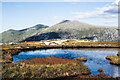
Pool on moorland north of Ceann Garbh
by Trevor Littlewood geograph for square NC3053 The small lochan is one of a number on the moorland shelf north of Ceann Garbh,... (more)
|
|
Snow patch below summit of Meall na Meoig
by Trevor Littlewood geograph for square NN4464 The large snow patch lies just north of the mountain's summit. Carn Dearg... (more)
Tags:
top:Air, Sky, WeatherX
type:GeographX
Minor Rocks
top:Rocks, Scree, CliffsX
subject:SnowX
Snow PatchesX
top:UplandsX
|
|
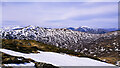
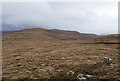
Moorland ridge north-east of Black Hill
by Trevor Littlewood geograph for square NY6847 Black Hill is merely a location along the ridge which rises out of the valley of... (more)
Tags:
type:GeographX
Minor Rocks
top:MoorlandX
Moorland RidgeX
top:Rocks, Scree, CliffsX
top:UplandsX
|
|
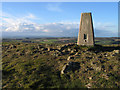
Trig point at Hooker Crag
by Trevor Littlewood geograph for square SD1198 The trig point is at Hooker Crag but that's not the highest point along the... (more)
Tags:
type:GeographX
top:Historic Sites and ArtefactsX
Minor Rocks
top:Rocks, Scree, CliffsX
subject:SummitX
Trig PointX
top:UplandsX
|

|
Rockiness on ridge of Cold Moor
by Trevor Littlewood geograph for square NZ5502 The moorland ridge of Cold Moor seen heading north towards its highest point at... (more)
Tags:
BridlewayX
type:GeographX
Heather MoorlandX
Minor Rocks
top:MoorlandX
Moorland RidgeX
top:PathsX
subject:RidgeX
top:Rocks, Scree, CliffsX
top:UplandsX
|
|
Moorland of Kirkby Fell
by Trevor Littlewood geograph for square SD8763 The view to the west from Kirkby Fell's summit with Rye Loaf Hill rising in... (more)
Tags:
type:GeographX
Grassy MoorlandX
Hill Summit AreaX
Minor Rocks
top:MoorlandX
top:Rocks, Scree, CliffsX
top:UplandsX
|
|
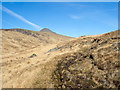
Steep bracken slope west of Gill Beck
by Trevor Littlewood geograph for square NY1205 The fragmenting remains of the previous year's bracken on a steep hill slope.
Tags:
Dead BrackenX
type:GeographX
Hill SlopeX
Minor Rocks
top:Rocks, Scree, CliffsX
subject:SlopeX
top:UplandsX
|
|
East ridge of Swirl How
by Trevor Littlewood geograph for square NY2700 The ridge descends to the col between Swirl How and Wetherlam/Black Sails... (more)
Tags:
top:Air, Sky, WeatherX
type:GeographX
Minor Rocks
Mountain RidgeX
subject:RidgeX
top:Rocks, Scree, CliffsX
Snow PatchesX
top:UplandsX
|
|
Ridge rising to Meall Garbh
by Trevor Littlewood geograph for square NN3773 Meall Garbh is the southern top of the Munro, Chno Dearg; it's viewed here... (more)
Tags:
type:GeographX
Minor Rocks
Mountain RidgeX
subject:RidgeX
top:Rocks, Scree, CliffsX
top:UplandsX
|
|
Remains of trig point on Ben Resipol
by Trevor Littlewood geograph for square NM7665 The trig point at the summit of Ben Resipol was destroyed some time ago, perhaps... (more)
Tags:
top:Derelict, DisusedX
type:GeographX
top:Historic Sites and ArtefactsX
Minor Rocks
Mountain Summit AreaX
top:Rocks, Scree, CliffsX
Stump of Trig PointX
subject:Trig PointX
Trig PointX
top:UplandsX
|
|
Ridge - An Aisridh Mhòr
by Trevor Littlewood geograph for square NM8978 An Aisridh Mhòr is a name applied at the ridge top descending to the west from... (more)
Tags:
type:GeographX
Minor Rocks
Mountain RidgeX
subject:RidgeX
top:Rocks, Scree, CliffsX
top:UplandsX
|
|
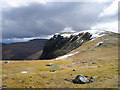
Ground of ridge east of summit of Meall Bhanabhie
by Trevor Littlewood geograph for square NN1178 Meall Bhanabhie is a hill of modest height north of Fort William and its... (more)
|
|
Summit area of Beinn na Gucaig
by Trevor Littlewood geograph for square NN0665 The view past the small cairn and trig point is generally to the north-east... (more)
Tags:
CairnX
type:GeographX
Minor Rocks
Mountain Summit AreaX
top:Rocks, Scree, CliffsX
subject:SummitX
Trig PointX
top:UplandsX
|
|
Summit ridge of Beinn Bhreac
by Trevor Littlewood geograph for square NG2454 Beinn Bhreac is a moorland hill of northern Skye lying between Loch Dunvegan and... (more)
Tags:
Grass and Heather MoorlandX
Minor Rocks
subject:MoorlandX
top:MoorlandX
Moorland RidgeX
top:Rocks, Scree, CliffsX
top:UplandsX
|
|
Path climbing in valley of Allt Teanga Brideig
by Trevor Littlewood geograph for square NM5632 The path passes through the length of the valley of the Allt Teanga Brideig... (more)
Tags:
Minor Rocks
Mountain PathX
Mountain SlopesX
subject:PathX
top:PathsX
top:Rocks, Scree, CliffsX
top:UplandsX
|
|
West ridge of Stybarrow Dodd
by Trevor Littlewood geograph for square NY3318 Stybarrow Dodd lies on the north side of the Sticks Pass route and is seen from... (more)
|
|
Bealach a' Chuirn
by Trevor Littlewood geograph for square NG4854 The Bealach a' Chuirn lies between Hartaval and The Storr; Hartaval is the... (more)
|