Geograph - photograph every grid square
About tags on Geograph
Tags
Geographical Context
Subjects
Types
Other Prefixes
Public Tags
Related Tags
|
Coverage Map
Tag:
Missile·Range
Showing images tagged with
Missile Range
tag.
View all tagged images
-
In Browser
Search within these images
:
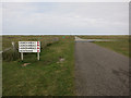
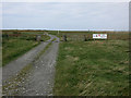
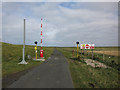
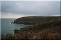
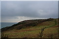
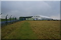
South Uist missile range
by
Hugh Venables
geograph for square
NF7642
There is access to the range when it is not active.
Tags:
top:
Defence, Military
X
Missile Range
island:
South Uist
X
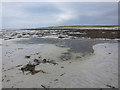
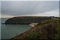
Beach near Ardivachar
by
Hugh Venables
geograph for square
NF7444
By the missile range, the beach is closed when the range is active.
Tags:
top:
Coastal
X
Missile Range
Sandy Beach
X
island:
South Uist
X
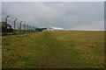
South Uist missile range
by
Hugh Venables
geograph for square
NF7542
A sign to the three launch areas and the rifle range. The area is generally open... (
more
)
Tags:
top:
Defence, Military
X
top:
Islands
X
Machair
X
Missile Range
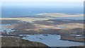
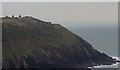
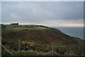
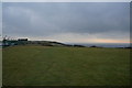
Loch Druidbeag and Ruabhal
by
Richard Webb
for square
NF7740
Ruabhal has tracking equipment for the missile range on the summit. Beyond Space... (
more
)
Tags:
loch:
Bi
X
top:
Coastal
X
top:
Defence, Military
X
loch:
Druidibeag
X
top:
Islands
X
top:
Lakes, Wetland, Bog
X
Machair
X
Missile Range
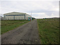
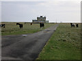
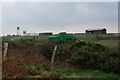
Entrance to the missile range at Gerinish
by
Hugh Venables
geograph for square
NF7641
The opening times are posted at a few points round the island.
Tags:
top:
Defence, Military
X
Missile Range
island:
South Uist
X
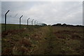
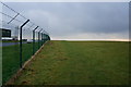
Mobile rocket launchers at Manorbier Missile Range
by
Ian S
for square
SS0796
Tags:
top:
Coastal
X
top:
Defence, Military
X
Missile Range
top:
Paths
X
long distance path:
Pembrokeshire Coast Path
X
Public Right of Way
X
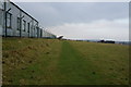
Path alongside Manorbier Missile Range
by
Ian S
geograph for square
SS0797
Tags:
top:
Coastal
X
top:
Defence, Military
X
Missile Range
top:
Paths
X
Public Right of Way
X
Closed path at Manorbier Missile Range
by
Ian S
geograph for square
SS0797
Tags:
top:
Coastal
X
top:
Defence, Military
X
Missile Range
top:
Paths
X
Missile range entry point
by
Hugh Venables
geograph for square
NF7541
By the beach at Gerinish.
Tags:
Arable Land
X
top:
Defence, Military
X
top:
Farm, Fishery, Market Gardening
X
Machair
X
Missile Range
island:
South Uist
X
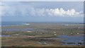
Loch Druidibeag and the northern machair of South Uist
by
Richard Webb
for square
NF7737
View northwards from Hatharsal. The immense flat landscape to the north of Loch... (
more
)
Tags:
Bog
X
top:
Defence, Military
X
loch:
Druidibeag
X
top:
Lakes, Wetland, Bog
X
Machair
X
Missile Range
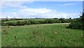
Cattle on the machair
by
Hugh Venables
geograph for square
NF7444
In the missile launch site, which is open when not in use, as displayed on signs... (
more
)
Tags:
top:
Defence, Military
X
top:
Farm, Fishery, Market Gardening
X
top:
Grassland
X
Missile Range
island:
South Uist
X
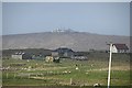
Tobha Mòr and Space City
by
Richard Webb
geograph for square
NF7536
A view over fields which are bounded by barbed wire at Howmore. The missile... (
more
)
Tags:
top:
Defence, Military
X
top:
Farm, Fishery, Market Gardening
X
Missile Range
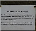
Air Defence Range Manorbier, Pembrokeshire
by
Ian S
for square
SS0796
Tags:
top:
Coastal
X
top:
Defence, Military
X
Missile Range
Air Defence Range Manorbier, Pembrokeshire
by
Ian S
geograph for square
SS0797
Tags:
top:
Coastal
X
top:
Defence, Military
X
Missile Range
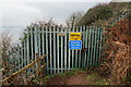
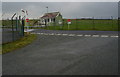
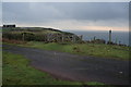
The Gatehouse at Manorbier Range, Pembrokeshire
by
Ian S
geograph for square
SS0797
Tags:
Army Gatehouse
X
top:
Coastal
X
top:
Defence, Military
X
Missile Range
top:
Paths
X
long distance path:
Pembrokeshire Coast Path
X
Public Right of Way
X
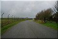
Manorbier Air Defence Range, Pembrokeshire
by
Ian S
geograph for square
SS0897
Tags:
top:
Coastal
X
top:
Defence, Military
X
Missile Range
top:
Paths
X
long distance path:
Pembrokeshire Coast Path
X
Public Right of Way
X
Notice at Air Defence Range Manorbier
by
Ian S
for square
SS0897
Tags:
top:
Coastal
X
top:
Defence, Military
X
Missile Range
top:
Paths
X
long distance path:
Pembrokeshire Coast Path
X
Public Right of Way
X
Ministry of Defence Site at Aberporth
by
Sandy Gerrard
for square
SN2452
Tags:
top:
Coastal
X
type:
Cross Grid
X
top:
Defence, Military
X
subject:
Defences
X
Missile Range
Pembrokeshire Coast Path at Conigar Pit
by
Ian S
geograph for square
SS0797
Link
Tags:
top:
Coastal
X
top:
Defence, Military
X
Missile Range
top:
Paths
X
long distance path:
Pembrokeshire Coast Path
X
Public Right of Way
X
Pembrokeshire Coast Path at Manorbier Camp
by
Ian S
geograph for square
SS0797
Tags:
top:
Coastal
X
top:
Defence, Military
X
Missile Range
top:
Paths
X
long distance path:
Pembrokeshire Coast Path
X
Public Right of Way
X
Pembrokeshire Coast Path at Skrinkle Haven
by
Ian S
geograph for square
SS0797
Tags:
top:
Coastal
X
top:
Defence, Military
X
Missile Range
top:
Paths
X
long distance path:
Pembrokeshire Coast Path
X
Public Right of Way
X
Footpath towards Manorbier Camp
by
Ian S
geograph for square
SS0797
Tags:
top:
Coastal
X
top:
Defence, Military
X
Missile Range
top:
Paths
X
Public Right of Way
X
Pembrokeshire Coast Path at Manorbier Camp
by
Ian S
geograph for square
SS0797
Tags:
top:
Coastal
X
top:
Defence, Military
X
top:
Farm, Fishery, Market Gardening
X
Missile Range
top:
Paths
X
long distance path:
Pembrokeshire Coast Path
X
Public Right of Way
X
Pembrokeshire Coast Path at Manorbier Camp
by
Ian S
geograph for square
SS0797
Tags:
top:
Coastal
X
top:
Defence, Military
X
top:
Farm, Fishery, Market Gardening
X
Missile Range
top:
Paths
X
long distance path:
Pembrokeshire Coast Path
X
Public Right of Way
X
Pembrokeshire Coast Path at Manorbier Camp
by
Ian S
geograph for square
SS0797
Tags:
top:
Coastal
X
top:
Defence, Military
X
top:
Farm, Fishery, Market Gardening
X
Missile Range
top:
Paths
X
long distance path:
Pembrokeshire Coast Path
X
Public Right of Way
X
Pembrokeshire Coast Path at Manorbier Camp
by
Ian S
geograph for square
SS0797
Tags:
top:
Coastal
X
top:
Defence, Military
X
top:
Farm, Fishery, Market Gardening
X
Farmhouse
X
Missile Range
top:
Paths
X
long distance path:
Pembrokeshire Coast Path
X
Public Right of Way
X
Pembrokeshire Coast Path at Manorbier Camp
by
Ian S
geograph for square
SS0797
Tags:
top:
Coastal
X
top:
Defence, Military
X
top:
Farm, Fishery, Market Gardening
X
Missile Range
top:
Paths
X
long distance path:
Pembrokeshire Coast Path
X
Public Right of Way
X
Pembrokeshire Coast Path at Skrinkle Haven
by
Ian S
for square
SS0797
Tags:
Bay
X
top:
Coastal
X
top:
Defence, Military
X
Missile Range
top:
Paths
X
long distance path:
Pembrokeshire Coast Path
X
Public Right of Way
X
View more in the Image Search
or
in Browser
View images matching 'Missile Range' anywhere
in
the tags
Don't click these:
PotMel 1
PotMel 2
☰
Home
View
Search
Marked Images
Maps
Browser
Explore
Showcase
New Images
Collections
Interact
Games
Discussions
Blog
Contributors
Submit
Statistics
Leaderboards
General
FAQ
Help Pages
Sitemap
Contact Us
Support Us
sponsored by
🔍
What to search:
Photos
Enter keywords or a location/postcode to search nearby images
Enter a Grid Reference
Placenames
Collections
Website Pages
Everything
Others:
Advanced Search
|
Image Browser
Or:
Coverage Map
|
Searchable Map
You are not logged in
login
|
register