Geograph - photograph every grid square
About tags on Geograph
Tags
Geographical Context
Subjects
Types
Other Prefixes
Public Tags
Related Tags
|
Coverage Map
Prefix:
name
Tag:
Kellingley·Colliery
Showing images tagged with
name:
Kellingley Colliery
tag.
View all tagged images
-
In Browser
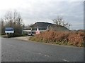
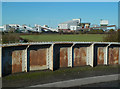
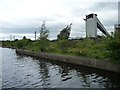
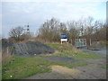
A Sudforth Lane entrance to Kellingley regeneration scheme
by
Christine Johnstone
geograph for square
SE5323
Formerly Kellingley Colliery, as this 2011 image shows
SE5323 : Sudforth Lane entrance, Kellingley Colliery
.
Tags:
top:
Derelict, Disused
X
subject:
Entrance
X
Former Colliery Site
X
type:
Geograph
X
name:
Kellingley Colliery
Locked Gates
X
Regeneration Scheme
X
Spoil Heap
X
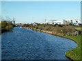
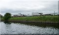
Aire & Calder Navigation from Stubbs Bridge
by
Chris Allen
for square
SE5223
This is a view of historic value. Kellingley Colliery on the right has closed... (
more
)
Tags:
Aire and Calder Navigation
X
Colliery
X
type:
Cross Grid
X
top:
Energy Infrastructure
X
Ferrybridge Power Station
X
name:
Kellingley Colliery
Power Station
X
subject:
River
X
top:
Rivers, Streams, Drainage
X
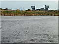
South bank of the River Aire at Kellingley Scalp
by
Christine Johnstone
geograph for square
SE5224
With Kellingley Colliery on the horizon.
Tags:
river:
Aire
X
top:
Canals
X
name:
Kellingley Colliery
Navigable River
X
subject:
River Bank
X
River Navigation
X
top:
Rivers, Streams, Drainage
X
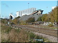
Kellingley Colliery - Tomorrow's energy standards today
by
Christine Johnstone
geograph for square
SE5223
The notice on the former colliery wharf can only be read as ironic, as it has... (
more
)
Tags:
canal:
Aire and Calder
X
Aire and Calder Navigation
X
top:
Canals
X
subject:
Coal Mine
X
Coal Stockpile
X
Former Colliery Wharf
X
name:
Kellingley Colliery
Notice
X
top:
Quarrying, Mining
X
Kellingley Colliery from Stubbs Bridge
by
Chris Allen
for square
SE5223
Britain's last dep coal mine that has now been closed and demolished. There... (
more
)
Tags:
Colliery
X
type:
Cross Grid
X
name:
Kellingley Colliery
subject:
Mine
X
top:
Quarrying, Mining
X
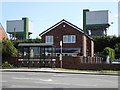
Kellingley Colliery
by
Chris Allen
for square
SE5223
The photographer position is approximate. This when it closed was Britain's... (
more
)
Tags:
Colliery
X
type:
Cross Grid
X
Ferrybridge Power Station
X
name:
Kellingley Colliery
subject:
Mine
X
Power Station
X
top:
Quarrying, Mining
X
Railway Line
X
Kellingley across the A645
by
Chris Allen
geograph for square
SE5223
This view is surely threatened as the colliery ceased production in December 2015.
Tags:
Colliery
X
type:
Geograph
X
name:
Kellingley Colliery
subject:
Mine
X
top:
Quarrying, Mining
X
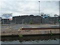
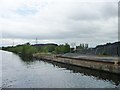
Disused wharf, Kellingley Colliery
by
Christine Johnstone
geograph for square
SE5223
On the north bank of the Aire & Calder Navigation. It has been announced... (
more
)
Tags:
Aire & Calder Navigation
X
canal:
Aire and Calder
X
Aire and Calder Navigation
X
Canal Bank
X
top:
Canals
X
subject:
Coal Mine
X
Former Colliery Wharf
X
name:
Kellingley Colliery
top:
Quarrying, Mining
X
Disused conveyor, Kellingley Colliery
by
Christine Johnstone
geograph for square
SE5223
On the north bank of the Aire & Calder Navigation. It has been announced... (
more
)
Tags:
Canal Bank
X
subject:
Coal Mine
X
Former Colliery Wharf
X
name:
Kellingley Colliery
top:
Quarrying, Mining
X
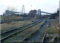
The railway into Kellingley Colliery
by
Alan Murray-Rust
geograph for square
SE5323
The tall hoppers just right of centre are the loading hoppers for block trains... (
more
)
Tags:
Colliery
X
Conveyor Bridge
X
name:
Kellingley Colliery
top:
Quarrying, Mining
X
Railway
X
top:
Railways
X
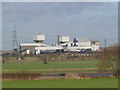
Kellingley Colliery
by
Alan Murray-Rust
for square
SE5223
One of the last three operating deep pits in the UK at the time the picture was taken.
Tags:
Colliery
X
name:
Kellingley Colliery
top:
Quarrying, Mining
X
Kellingley Colliery, from the Aire & Calder
by
Christine Johnstone
geograph for square
SE5223
It has been announced that the pit will close in December 2015.
Tags:
Canal Bank
X
subject:
Coal Mine
X
name:
Kellingley Colliery
top:
Quarrying, Mining
X
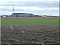
Westbound traffic, M62
by
Christine Johnstone
geograph for square
SE5322
With farmland north of Cobcroft Lane in the foreground, and Kellingley Colliery... (
more
)
Tags:
top:
Farm, Fishery, Market Gardening
X
Farmland
X
name:
Kellingley Colliery
motorway:
M62
X
Ploughed Field
X
top:
Roads, Road Transport
X
Entrance to Kellingley regeneration scheme, Beal Lane
by
Christine Johnstone
geograph for square
SE5222
Officially locked and blocked, but people with bikes have found a way in. The... (
more
)
Tags:
top:
Derelict, Disused
X
subject:
Entrance
X
Entrance Blocked
X
Former Colliery Site
X
type:
Geograph
X
name:
Kellingley Colliery
Locked Gates
X
Public Bridleway
X
Regeneration Scheme
X
View more in the Image Search
or
in Browser
View images matching 'Kellingley Colliery' anywhere
in
the tags
Don't click these:
PotMel 1
PotMel 2
☰
Home
View
Search
Marked Images
Maps
Browser
Explore
Showcase
New Images
Collections
Interact
Games
Discussions
Blog
Contributors
Submit
Statistics
Leaderboards
General
FAQ
Help Pages
Sitemap
Contact Us
Support Us
sponsored by
🔍
What to search:
Photos
Enter keywords or a location/postcode to search nearby images
Enter a Grid Reference
Placenames
Collections
Website Pages
Everything
Others:
Advanced Search
|
Image Browser
Or:
Coverage Map
|
Searchable Map
You are not logged in
login
|
register