|
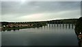
River Tweed
by Steven Haslington
geograph for square NT9952
The River Tweed in Northumberland, with the rail bridge between Tweedmouth and... (more)
|

|
Berwick-upon-Tweed Travelodge
by Steven Haslington
geograph for square NT9954
A Travelodge motel in the Newfields area of Berwick-upon-Tweed, in... (more)
|
|
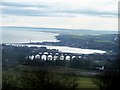
Berwick upon Tweed
by David Chatterton
geograph for square NU0052
A view of Berwick from the viewpoint on Halidon Hill, the site of a battle... (more)
|
|
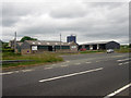
Conundrum farm, Berwick-upon-Tweed
by Graham Robson
geograph for square NT9855
Looking across the A1 toward the buildings of Conundrum Farm on the northern... (more)
|
|
East Coast Train north of Berwick-upon-Tweed
by Graham Robson
geograph for square NT9855
An East Coast train is travelling south along the East coast Mainline north of... (more)
|
|
Coastal Northumberland : View northwards up the coast to Needles Eye, near Berwick-upon-Tweed
by Richard West
geograph for square NT9955
A stunneroo day on the east coast, north of Berwick.
|
|
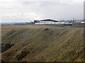
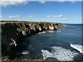
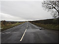
Traffic on the A1 north of Berwick
by Graham Robson
geograph for square NT9855
Looking at traffic using the short stretch of dual carriageway north of... (more)
|
|
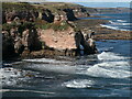
Coastal Northumberland : Low tide at Needles Eye, near Berwick-upon-Tweed
by Richard West
geograph for square NT9955
|
|
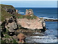
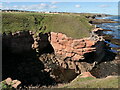
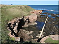
Coastal Northumberland : Erosion of sandstone cliffs at Needles Eye, near Berwick-upon-Tweed
by Richard West
geograph for square NT9955
|
|
Coastal Northumberland : Sandstone at Brotherston's Hole, near Berwick-upon-Tweed
by Richard West
geograph for square NU0054
|
|
Coastal Northumberland : Coastal Erosion at Brotherston's Hole, near Berwick-upon-Tweed
by Richard West
geograph for square NU0054
|
|
Buildings at Folly Farm
by Graham Robson
geograph for square NT9856
Three of the farm buildings at Folly Farm, north of Berwick-upon-Tweed.
|
|
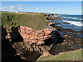
Coastal Northumberland : Brotherston's Hole, north of Berwick-upon-Tweed
by Richard West
geograph for square NU0054
|
|
Coastal Northumberland : Sea caves and cliffs south of Brotherston's Hole, Berwick-upon-Tweed
by Richard West
geograph for square NU0054
|
|
Coastal Northumberland : View to cliffs on north side of Dodd's Well, Berwick-upon-Tweed
by Richard West
geograph for square NU0054
|
|
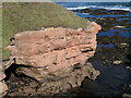
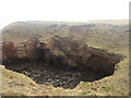
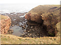
Erosion at Brotherston's Hole, Berwick-upon-Tweed
by Graham Robson
geograph for square NU0054
Looking into Brotherston's Hole. On the far side of the hole the large... (more)
|
|
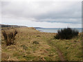
Cliff top public footpath
by Graham Robson
geograph for square NT9955
The public footpath runs along the top of cliffs north of Berwick-upon-Tweed.... (more)
|
|
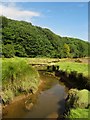
The Common Burn near its confluence with the River Tweed
by Graham Robson
geograph for square NT9752
Looking down stream along the Common Burn as it flows towards its confluence... (more)
|
|
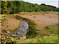
The Common Burn entering the Tweed
by Graham Robson
geograph for square NT9752
The channel carrying the Common Burn as it enters the River Tweed. At high tide... (more)
|
|
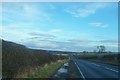
The A698 towards Berwick
by David Chatterton
for square NT9751
A rather misty view eastwards downhill towards the A1 and Berwick in the distance.
|
|
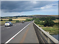
The A1 crossing the River Tweed
by Graham Robson
geograph for square NT9751
Looking north along the A1 as it crosses the River Tweed.
|
|
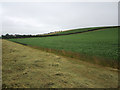
Field of Peas near Brow of the Hill
by Graham Robson
geograph for square NT9754
A field of peas is in flower near Brow of the Hill. The photo was taken from a... (more)
|
|
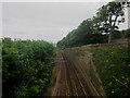
Looking south along the East Coast Mainline near Marshall Meadows
by Graham Robson
geograph for square NT9856
Looking south from the road bridge over the tracks of the East Coast Mainline... (more)
|
|
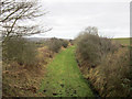
Looking east along line of former railway, near Loanend
by Graham Robson
geograph for square NT9450
The line of a former railway line passing under a country road near Loanend.... (more)
|
|
Sowing winter cereals near Letham Shank
by Graham Robson
geograph for square NT9753
A New Holland tractor and combination seed drill are sowing seed, probably a... (more)
|
|
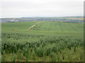
Arable field near Brow of the Hill
by Graham Robson
geograph for square NT9754
A field of oats is growing on land south east of Brow of the Hill. The west end... (more)
|
|
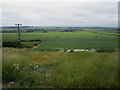
Arable land west of White Damhead Farm
by Graham Robson
geograph for square NT9653
Looking south over arable land to the west of White Damhead Farm.
|
|
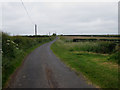
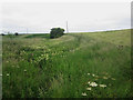
Country road west of White Damhead Farm
by Graham Robson
geograph for square NT9653
Looking along the country road west of White Damhead Farm.
|
|
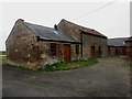
Stone farm building at White Damhead Farm
by Graham Robson
geograph for square NT9653
Part of the range of stone farm buildings at White Damhead Farm.
|
|
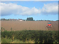
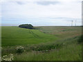
Arable land north of Folly Farm
by Graham Robson
geograph for square NT9756
Arable land seen from the A1 road north of Folly Farm.
|
|
Looking west along the A6105, Duns Road
by Graham Robson
geograph for square NT9854
Looking west along the A6105, Duns Road from its junction with the minor road... (more)
|
|
Coastal Northumberland : Caves, cliffs and outflow pipe, south of Brotherston's Hole
by Richard West
geograph for square NU0054
|
|
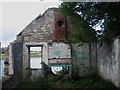
Interior of Clayhole Shiel
by Graham Robson
for square NT9751
The interior of the roofless, derelict Clayhole Shiel.
|
|
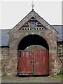
Entrance to range of buildings at Baldersbury Hill
by Graham Robson
for square NT9553
The central entrance archway to the late 19th century range of buildings at... (more)
|
|
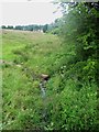
White Damhead Burn
by Graham Robson
geograph for square NT9653
This trickle of water is the White Damhead Burn. The burn flows along the right... (more)
|
|
White Damhead Burn valley
by Graham Robson
geograph for square NT9653
Somewhere at the bottom of this mass of grass and wild plants the White Damhead... (more)
|
|
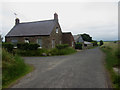
Country road past High Letham
by Graham Robson
geograph for square NT9753
Looking along the country road which runs past the farm buildings and cottages... (more)
|
|
Looking towards a walled enclosure at Sanson Seal
by Graham Robson
geograph for square NT9654
Looking across arable land towards a walled enclosure at Sanson Seal. I think... (more)
|
|
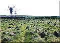
Footpath over the railway
by Barbara Carr
geograph for square NT9955
Leaving the scary cliffs, the footpath goes directly over the fast East Coast railway!
|
|
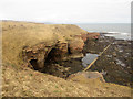
Caves in the cliff face of Burgess Cove
by Graham Robson
geograph for square NU0054
Looking down into Burgess Cove at the caves in the cliff face. What looks like a... (more)
|
|
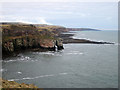
Looking out to sea from above Brotherston's Hole
by Graham Robson
geograph for square NU0054
Looking into Brotherston's Hole. The cove creates a natural obstacle to be... (more)
|
|
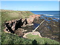
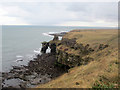
Looking south towards Needles Eye rock arch
by Graham Robson
geograph for square NT9955
Looking south from the cliff tops towards Needles Eye, a natural rock arch on... (more)
|
|
Looking north towards Needle's Eye
by Graham Robson
geograph for square NT9955
Looking north along the coast towards the Needles Eye Arch, formed by the... (more)
|
|
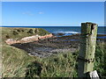
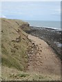
Coastal Erosion east of Newfields
by Graham Robson
geograph for square NT9954
Looking from the cliff top, coastal footpath onto a short section of beach. The... (more)
|
|
Former railway bridge, Mount Pleasant
by Graham Robson
geograph for square NT9550
The railway cutting originally crossed by the bridge has been filled in at some... (more)
|
|
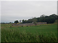
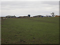
Looking towards West Longridge farm
by Graham Robson
geograph for square NT9549
Looking across a grass field towards the farm buildings at West Longridge.
|
|
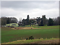
Looking towards Longridge Towers
by Graham Robson
for square NT9549
Looking across Murton Dean towards Longridge Towers. The site now houses a... (more)
|
|
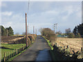
Narrow lane to Heathery Tops
by Graham Robson
geograph for square NU0049
Looking along the narrow lane, which serves the residential properties at... (more)
|
|
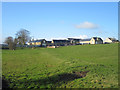
Redeveloped farm steading at Heathery Tops
by Graham Robson
for square NT9950
The farm buildings at Heathery Tops have undergone significant remodelling and... (more)
|
|
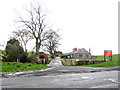
Private lane to Castle Hills Farm
by Graham Robson
geograph for square NT9853
Looking down the private lane towards Castle Hills Farm.
|