Public Tags
Other tags: place:Dalquhurn
Showing images tagged with near:Dalquhurn tag.
|
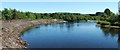
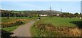
The River Leven at Dalquhurn Point
by Lairich Rig geograph for square NS3977 Category: River The southern side of the point is visible on the left. The large buildings on... (more)
|
|
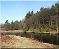
The River Leven at Dalquhurn Point
by Lairich Rig geograph for square NS3977 Category: River The other prominent loop in the river is that at Cordale Point, in the adjacent... (more)
|
|
The River Leven at Dalquhurn Point
by Lairich Rig geograph for square NS3977 Category: River The same stretch of the river is viewed in the opposite direction in... (more)
|
|
The River Leven at Dalquhurn Point
by Lairich Rig geograph for square NS3977 Category: River For further comments on the Point itself, see NS3977 : The River Leven at Dalquhurn Point.
On the other side... (more)
|
|
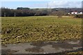
The former Pillanflatt
by Lairich Rig geograph for square NS3977 Category: Field The "Atlas of Scotland" (published by Joan Blaeu in 1654, but based on... (more)
Tags:
former:BleachfieldX
near:Dalquhurn
top:Farm, Fishery, Market GardeningX
FieldX
National Cycle NetworkX
NCN 7X
PillanflattX
near:River LevenX
person:Robert the BruceX
ToponymyX
|
|
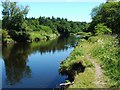
The River Leven at Dalquhurn Point
by Lairich Rig geograph for square NS3977 Category: River The northern side of the point is visible on the right. Compare NS3977 : The River Leven at Dalquhurn Point,... (more)
|
|
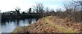
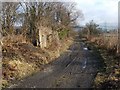
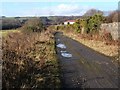
The Howgate
by Lairich Rig geograph for square NS3977 Category: Track Visible on the left is a surviving portion of the southern wall of the former... (more)
|
|
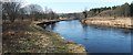
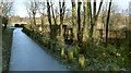
Former railway bridge over a lade
by Lairich Rig geograph for square NS3977 The metal-sided bridge is shown from the other side in NS3977 : The Lade at Dalquhurn Renton. As shown... (more)
|
|
The Howgate
by Lairich Rig geograph for square NS3977 Category: Track For the main description, see NS3977 : The Howgate, which is a view in the opposite... (more)
|
|
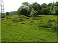
The former Pillanflatt
by Lairich Rig geograph for square NS3977 Category: Field See NS3977 : The former Pillanflatt for the main historical description of this area, and a... (more)
Tags:
former:BleachfieldX
near:Dalquhurn
top:Farm, Fishery, Market GardeningX
FieldX
National Cycle NetworkX
NCN 7X
PillanflattX
near:River LevenX
|
|
The line of an old track
by Lairich Rig geograph for square NS3877 Category: Ditch This photograph was taken at the far side of the field that is shown in... (more)
|