Public Tags
Other tags: Earlsferry
Showing images tagged with near:Earlsferry tag.
|
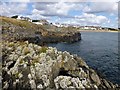
View Towards Earlsferry
by Rude Health geograph for square NT4899 A view towards the coastal village of Earlsferry from the rocks near Chapel Ness.
Tags:
top:Air, Sky, WeatherX
Chapel NessX
subject:CoastX
top:CoastalX
near:Earlsferry
top:Estuary, MarineX
top:LowlandsX
top:Village, Rural SettlementX
|
|
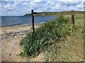
Fife Coastal Path
by Rude Health geograph for square NT4799 The Fife Coastal Path near Earlsferry Links. Should I walk along the beach or... (more)
Tags:
top:Air, Sky, WeatherX
subject:BeachX
top:CoastalX
near:Earlsferry
Earlsferry LinksX
top:Estuary, MarineX
Fife Coastal PathX
top:PathsX
top:Sport, LeisureX
|
|
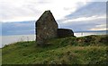
Ruined chapel?
by Bill Kasman geograph for square NT4899 Sited at Earlsferry Point there is some doubt as to what this building was. The... (more)
Tags:
top:CoastalX
top:Derelict, DisusedX
near:Earlsferry
Earlsferry PointX
type:GeographX
top:Historic Sites and ArtefactsX
Ruined ChapelX
top:Suburb, Urban FringeX
|
|
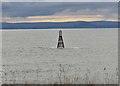
Navigation beacon
by Bill Kasman geograph for square NT4899 Dating from 1847 this beacon marks the rocks of East Vows which lie just... (more)
|
|
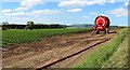
Watering a field of potatoes
by Bill Kasman geograph for square NO4801 Just outside of the Fife village of Earlsferry this field of potatoes was being... (more)
Tags:
CropX
near:Earlsferry
top:Farm, Fishery, Market GardeningX
type:GeographX
IrrigationX
crop:PotatoesX
top:Suburb, Urban FringeX
|
|
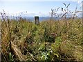
Kincraig Hill Trig
by Rude Health geograph for square NT4699 Parked in Earlferry then bagged Chapel Ness and then used the Fife Coastal Trail... (more)
Tags:
top:CoastalX
near:Earlsferry
top:GrasslandX
Kincraig HillX
P49X
subject:Trig PointX
TumpX
top:UplandsX
|
|
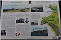
Information board
by Bill Kasman for square NT4799 This one of several information boards in the area.
Tags:
type:Close LookX
near:Earlsferry
Elie Chain WalkX
Fife Coastal PathX
top:Historic Sites and ArtefactsX
top:Suburb, Urban FringeX
|