Geograph - photograph every grid square
About tags on Geograph
Tags
Geographical Context
Subjects
Types
Other Prefixes
Public Tags
Related Tags
|
Coverage Map
Prefix:
near
Tag:
Lodge·Farm
Other tags:
Lodge Farm
farm:
Lodge Farm
place:
Lodge Farm
to:
Lodge Farm
Showing images tagged with
near:
Lodge Farm
tag.
View all tagged images
-
In Browser
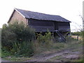
Barn off Lodge Lane
by
Geographer
geograph for square
TM1082
At the junction with the B1077 Shelfanger Road near Lodge Farm
Tags:
B1077
X
B1077 Shelfanger Road
X
subject:
Barn
X
top:
Farm, Fishery, Market Gardening
X
near:
Lodge Farm
off:
Lodge Lane
X
Road Junction
X
at:
Shelfanger
X
Shelfanger Road
X
B1077 Shelfanger Road, Shelfanger
by
Geographer
geograph for square
TM1082
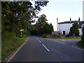
Looking towards Diss at the junction with Lodge Lane near Lodge Farm
Tags:
B Road (Classified B)
X
B1077
X
B1077 Shelfanger Road
X
looking towards:
Diss
X
near:
Lodge Farm
Lodge Lane
X
subject:
Road Junction
X
top:
Roads, Road Transport
X
at:
Shelfanger
X
Shelfanger Road
X
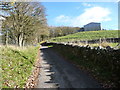
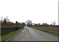
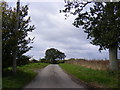
Lodge Road approaching Lodge Farm
by
Christine Johnstone
geograph for square
SD8261
A farm access lane and public bridleway.
Tags:
rights of way:
Bridleway
X
Bridleway
X
Farm Access Road
X
type:
Geograph
X
subject:
Lane
X
near:
Lodge Farm
on:
Lodge Road
X
Public Bridleway
X
top:
Roads, Road Transport
X
national park:
Yorkshire Dales
X
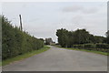
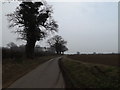
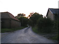
Road to Lodge Farm
by
J.Hannan-Briggs
geograph for square
TF1143
Off Asgarby Road.
Tags:
near:
Asgarby Road
X
Farm Access Track
X
near:
Lodge Farm
top:
Roads, Road Transport
X
Rectory Road, Bacton
by
Geographer
geograph for square
TM0466
Near Lodge Farm
Tags:
at:
Bacton
X
near:
Lodge Farm
Rectory Road
X
subject:
Road
X
top:
Roads, Road Transport
X
Gawdy Lane, Harleston
by
Geographer
geograph for square
TM2484
Near Lodge Farm
Tags:
Gawdy Lane
X
at:
Harleston
X
subject:
Lane
X
near:
Lodge Farm
top:
Roads, Road Transport
X
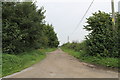
Moor Lane, near Lodge Farm
by
J.Hannan-Briggs
geograph for square
SK8364
Tags:
near:
Lodge Farm
lane:
Moor Lane
X
top:
Roads, Road Transport
X
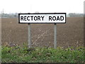
Rectory Road sign
by
Geographer
for square
TM0466
On Rectory Road near Lodge Farm
Tags:
at:
Bacton
X
near:
Lodge Farm
on:
Rectory Road
X
Road Name Sign
X
top:
Roads, Road Transport
X
subject:
Sign
X
Mill Road, Peasenhall
by
Geographer
geograph for square
TM3469
Category: Road
Looking towards Segmore Lane footpath near Lodge Farm Road No.U2611
Tags:
Footpath
X
near:
Lodge Farm
Mill Road
X
at:
Peasenhall
X
subject:
Road
X
looking towards:
Segmore Lane Footpath
X
U Road (Classified U)
X
Lodge Lane, Shelfanger
by
Geographer
geograph for square
TM1082
At the junction with the B1077 Shelfanger Road
Tags:
B1077
X
B1077 Shelfanger Road
X
near:
Lodge Farm
Lodge Lane
X
subject:
Road Junction
X
top:
Roads, Road Transport
X
at:
Shelfanger
X
Shelfanger Road
X
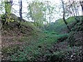
Dry watercourse, east of Lodge Farm
by
Christine Johnstone
geograph for square
SD8261
Issue-fed, and obviously in spate sometimes.
Tags:
type:
Geograph
X
near:
Lodge Farm
top:
Rivers, Streams, Drainage
X
subject:
Stream
X
Water Erosion
X
Watercourse
X
View more in the Image Search
or
in Browser
View images matching 'Lodge Farm' anywhere
in
the tags
Don't click these:
PotMel 1
PotMel 2
☰
Home
View
Search
Marked Images
Maps
Browser
Explore
Showcase
New Images
Collections
Interact
Games
Discussions
Blog
Contributors
Submit
Statistics
Leaderboards
General
FAQ
Help Pages
Sitemap
Contact Us
Support Us
sponsored by
🔍
What to search:
Photos
Enter keywords or a location/postcode to search nearby images
Enter a Grid Reference
Placenames
Collections
Website Pages
Everything
Others:
Advanced Search
|
Image Browser
Or:
Coverage Map
|
Searchable Map
You are not logged in
login
|
register