Geograph - photograph every grid square
About tags on Geograph
Tags
Geographical Context
Subjects
Types
Other Prefixes
Public Tags
Related Tags
|
Coverage Map
Prefix:
near
Tag:
Marlinspike·Hall
Other tags:
Marlinspike Hall
looking towards:
Marlinspike Hall
to:
Marlinspike Hall
Showing images tagged with
near:
Marlinspike Hall
tag.
View all tagged images
-
In Browser
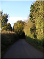
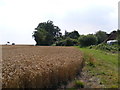
Bramfield Road,Walpole
by
Geographer
geograph for square
TM3674
Looking towards Peasenhall Road near Marlinspike Hall Road No.C208
Tags:
Bramfield Road
X
C Road (Classified C)
X
near:
Marlinspike Hall
looking towards:
Peasenhall Road
X
Peasenhall Road
X
subject:
Road
X
top:
Roads, Road Transport
X
at:
Walpole
X
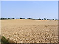
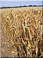
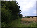
Wheat field off Bramfield Road
by
Geographer
geograph for square
TM3674
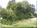
Near Marlinspike Hall
Tags:
off:
Bramfield Road
X
top:
Farm, Fishery, Market Gardening
X
subject:
Farmland
X
Field
X
near:
Marlinspike Hall
Permissive Path
X
at:
Walpole
X
Wheat Crop
X
Wheat Field
X
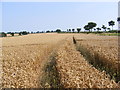
Wheat Crop along the tram lines
by
Geographer
geograph for square
TM3674
Off Bramfield Road near Marlinspike Hall
Tags:
off:
Bramfield Road
X
top:
Farm, Fishery, Market Gardening
X
subject:
Farmland
X
near:
Marlinspike Hall
along:
The Tram Lines
X
at:
Walpole
X
Wheat Crop
X
Wheat Field
X
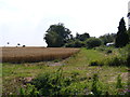
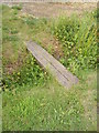
Permissive Path to Bramfield Road
by
Geographer
geograph for square
TM3674
Near Marlinspike Hall
Tags:
looking towards:
Bramfield Road
X
to:
Bramfield Road
X
near:
Marlinspike Hall
subject:
Path
X
top:
Paths
X
Permissive Path
X
at:
Walpole
X
Permissive Path to Bramfield Road
by
Geographer
geograph for square
TM3674
Near Marlinspike Hall
Tags:
to:
Bramfield Road
X
Crop
X
Field
X
near:
Marlinspike Hall
subject:
Path
X
top:
Paths
X
Permissive Path
X
at:
Walpole
X
Wheat
X
Wheat Crop
X
Wheat Field
X
Permissive Path to the B1117 Halesworth Road
by
Geographer
geograph for square
TM3674
Off Bramfield Road near Marlinspike Hall
Tags:
B1117
X
off:
Bramfield Road
X
Field
X
Halesworth Road
X
near:
Marlinspike Hall
subject:
Path
X
top:
Paths
X
Permissive Path
X
to:
The B1117 Halesworth Road
X
at:
Walpole
X
Wheat Field
X
Wheat Crop off Bramfield Road
by
Geographer
geograph for square
TM3674
Near Marlinspike Hall
Tags:
off:
Bramfield Road
X
Crop
X
top:
Farm, Fishery, Market Gardening
X
Field
X
near:
Marlinspike Hall
Permissive Path
X
at:
Walpole
X
Wheat
X
Wheat Crop
X
Wheat Field
X
Permissive Path to the B1117 Halesworth Road
by
Geographer
geograph for square
TM3674
Off Bramfield Road near Marlinspike Hall
Tags:
B1117
X
off:
Bramfield Road
X
Field
X
Halesworth Road
X
near:
Marlinspike Hall
subject:
Path
X
top:
Paths
X
Permissive Access
X
Permissive Path
X
to:
The B1117 Halesworth Road
X
at:
Walpole
X
Wheat Field
X
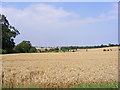
Wheat field off Bramfield Road
by
Geographer
geograph for square
TM3674
Near Marlinspike Hall
Tags:
off:
Bramfield Road
X
Bramfield Road
X
top:
Farm, Fishery, Market Gardening
X
subject:
Farmland
X
Field
X
near:
Marlinspike Hall
at:
Walpole
X
Wheat Field
X
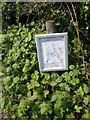
Permissive Access map off Bramfield Road
by
Geographer
for square
TM3674
Near Marlinspike Hall
Tags:
off:
Bramfield Road
X
Map
X
near:
Marlinspike Hall
top:
Paths
X
Permissive Access
X
subject:
Sign
X
at:
Walpole
X
Footbridge of the permissive Path to the B1117 Halesworth Road
by
Geographer
geograph for square
TM3674
Off Bramfield Road near Marlinspike Hall
Tags:
B1117
X
off:
Bramfield Road
X
Bramfield Road
X
Footbridge
X
Halesworth Road
X
near:
Marlinspike Hall
subject:
Path
X
top:
Paths
X
Permissive Path
X
to:
The B1117 Halesworth Road
X
at:
Walpole
X
Permissive Path to the B1117 Halesworth Road
by
Geographer
geograph for square
TM3674
Off Bramfield Road near Marlinspike Hall
Tags:
B1117
X
off:
Bramfield Road
X
Halesworth Road
X
near:
Marlinspike Hall
subject:
Path
X
top:
Paths
X
Permissive Path
X
to:
The B1117 Halesworth Road
X
at:
Walpole
X
Permissive Path to the B1117 Halesworth Road
by
Geographer
geograph for square
TM3674
Off Bramfield Road near Marlinspike Hall
Tags:
B1117
X
off:
Bramfield Road
X
Halesworth Road
X
near:
Marlinspike Hall
subject:
Path
X
top:
Paths
X
Permissive Path
X
to:
The B1117 Halesworth Road
X
at:
Walpole
X
View more in the Image Search
or
in Browser
View images matching 'Marlinspike Hall' anywhere
in
the tags
Don't click these:
PotMel 1
PotMel 2
☰
Home
View
Search
Marked Images
Maps
Browser
Explore
Showcase
New Images
Collections
Interact
Games
Discussions
Blog
Contributors
Submit
Statistics
Leaderboards
General
FAQ
Help Pages
Sitemap
Contact Us
Support Us
sponsored by
🔍
What to search:
Photos
Enter keywords or a location/postcode to search nearby images
Enter a Grid Reference
Placenames
Collections
Website Pages
Everything
Others:
Advanced Search
|
Image Browser
Or:
Coverage Map
|
Searchable Map
You are not logged in
login
|
register