Geograph - photograph every grid square
About tags on Geograph
Tags
Geographical Context
Subjects
Types
Other Prefixes
Public Tags
Related Tags
|
Coverage Map
Prefix:
near
Tag:
Stratford-Upon-Avon
Other tags:
Stratford-Upon-Avon
place:
Stratford-Upon-Avon
Showing images tagged with
near:
Stratford-Upon-Avon
tag.
View all tagged images
-
In Browser
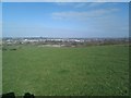
Overlooking Stratford-upon-Avon
by
Barry Hunter
geograph for square
SP1754
Category: Farmland
Taken next to the Bordon Hill Trigpoint. (over-watched by cows:
SP1754 : Inquistive Cows on Bordon Hill
)
Tags:
Bordon Hill
X
Field
X
top:
Grassland
X
top:
Lowlands
X
Stratford Upon Avon
X
near:
Stratford-Upon-Avon
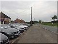
Roadside car sales north of Stratford-upon-Avon
by
Robin Stott
geograph for square
SP1858
The A3400 Birmingham Road approaches Pathlow. This forecourt is opposite the... (
more
)
Tags:
road:
A3400
X
Arden
X
Bus Stop
X
top:
Business, Retail, Services
X
Car Dealer
X
Car Sales
X
postcode district:
CV37
X
type:
Geograph
X
top:
Lowlands
X
Middle of Nowhere
X
near:
Pathlow
X
top:
Roads, Road Transport
X
near:
Stratford-Upon-Avon
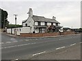
The former Dun Cow pub by the A3400
by
Robin Stott
geograph for square
SP1858
It was boarded up and to let in 2012
SP1858 : The Dun Cow
and is now a private dwelling.... (
more
)
Tags:
road:
A3400
X
Arden
X
postcode district:
CV37
X
Former Pub
X
type:
Geograph
X
top:
Housing, Dwellings
X
top:
Lowlands
X
Middle of Nowhere
X
near:
Pathlow
X
Private House
X
near:
Stratford-Upon-Avon
Ingon Lane by Ingon Bank Cottages
by
Robin Stott
geograph for square
SP2157
Postbox CV37 94. On the left is a small parking space to serve visitors to... (
more
)
Tags:
postcode area:
CV37
X
top:
Lowlands
X
top:
Roads, Road Transport
X
near:
Stratford-Upon-Avon
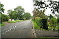
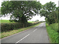
Bend on Ingon Lane
by
Robin Stott
geograph for square
SP2157
Tags:
postcode area:
CV37
X
Hedgerow Oak
X
top:
Lowlands
X
top:
Roads, Road Transport
X
near:
Stratford-Upon-Avon
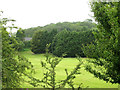
Potato Hill
by
Robin Stott
geograph for square
SP2156
Glimpsed from the A439 Warwick Road.
Tags:
top:
Country Estates
X
postcode area:
CV37
X
top:
Lowlands
X
near:
Stratford-Upon-Avon
top:
Suburb, Urban Fringe
X
top:
Woodland, Forest
X
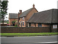
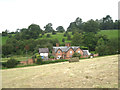
Oxstalls Farmhouse
by
Robin Stott
geograph for square
SP2156
The complex is by the Warwick Road A439, opposite the drive to the Welcombe House Hotel.
Tags:
postcode area:
CV37
X
converted:
Farm Buildings
X
top:
Flat Landscapes
X
top:
Housing, Dwellings
X
near:
Stratford-Upon-Avon
top:
Suburb, Urban Fringe
X
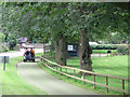
By buggy to the first tee, Welcombe Golf Course
by
Robin Stott
geograph for square
SP2156
Four young men (two in another buggy) were meeting up for a round of golf.
Tags:
top:
Country Estates
X
postcode area:
CV37
X
Golf Course
X
top:
Lowlands
X
top:
Sport, Leisure
X
near:
Stratford-Upon-Avon
top:
Suburb, Urban Fringe
X
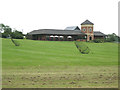
Clubhouse and practice area, Welcombe Golf Course
by
Robin Stott
geograph for square
SP2156
All those daisies in the grass are golf balls.
Tags:
top:
Business, Retail, Services
X
top:
Country Estates
X
postcode area:
CV37
X
Golf Course
X
top:
Lowlands
X
near:
Stratford-Upon-Avon
top:
Suburb, Urban Fringe
X
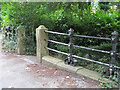
Garden railings and gate pillars, Welcombe House Hotel
by
Robin Stott
for square
SP2056
This horizontal bar fence has grotesquely shaped and modelled cast iron supports... (
more
)
Tags:
top:
Business, Retail, Services
X
top:
Country Estates
X
postcode area:
CV37
X
railings:
Horizontal Bar
X
Hotel
X
top:
Lowlands
X
near:
Stratford-Upon-Avon
top:
Suburb, Urban Fringe
X
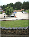
Car park north of Welcombe House Hotel
by
Robin Stott
geograph for square
SP2056
With a neat stack of bricks forming a low wall in the foreground.
Tags:
top:
Business, Retail, Services
X
top:
Country Estates
X
postcode area:
CV37
X
Hotel
X
top:
Lowlands
X
near:
Stratford-Upon-Avon
top:
Suburb, Urban Fringe
X
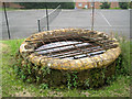
Former fountain basin, Welcombe Hotel grounds
by
Robin Stott
for square
SP2056
Welcombe (now Welcombe House Hotel) was completed for Mark Philips in 1869. This... (
more
)
Tags:
top:
Business, Retail, Services
X
top:
Country Estates
X
postcode area:
CV37
X
former:
Fountain
X
Hotel
X
top:
Lowlands
X
near:
Stratford-Upon-Avon
top:
Suburb, Urban Fringe
X
Welcombe Hotel Cottage, Welcombe Bank
by
Robin Stott
geograph for square
SP2056
Seen from the Welcombe Hills Country Park, on the hillside below the mighty... (
more
)
Tags:
postcode area:
CV37
X
top:
Housing, Dwellings
X
top:
Lowlands
X
near:
Stratford-Upon-Avon
top:
Suburb, Urban Fringe
X
View more in the Image Search
or
in Browser
View images matching 'Stratford-Upon-Avon' anywhere
in
the tags
Don't click these:
PotMel 1
PotMel 2
☰
Home
View
Search
Marked Images
Maps
Browser
Explore
Showcase
New Images
Collections
Interact
Games
Discussions
Blog
Contributors
Submit
Statistics
Leaderboards
General
FAQ
Help Pages
Sitemap
Contact Us
Support Us
sponsored by
🔍
What to search:
Photos
Enter keywords or a location/postcode to search nearby images
Enter a Grid Reference
Placenames
Collections
Website Pages
Everything
Others:
Advanced Search
|
Image Browser
Or:
Coverage Map
|
Searchable Map
You are not logged in
login
|
register