Public Tags
Tag: No·Through·Road
Other tags: road sign:No Through Road
Showing latest 50 of 1,319 images tagged with No Through Road tag.
|
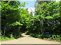
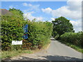
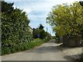
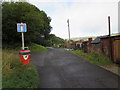
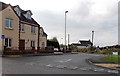
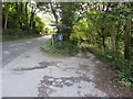
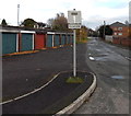
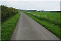
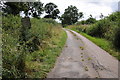
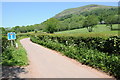
Duckmead Lane, Liss, near Petersfield
by Malc McDonald geograph for square SU7828 Duckmead Lane is a narrow lane in the South Downs National Park. The blue signs... (more)
Tags:
type:GeographX
county:HampshireX
subject:LaneX
near:LissX
Minor LaneX
Minor RoadX
Minor Rural LaneX
Narrow Country LaneX
Narrow LaneX
road sign:No Through Road
No Through Road
No Through Road SignX
No Through Road SignsX
near:PetersfieldX
top:Roads, Road TransportX
Rural LaneX
national park:South DownsX
South Downs National ParkX
place:South Downs National ParkX
|
|
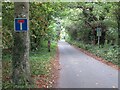
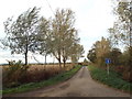
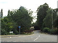
Beryl Burton Cycleway, near Knaresborough
by Malc McDonald geograph for square SE3357 A view along the Beryl Burton Cycleway, looking westwards towards Harrogate.... (more)
Tags:
Beryl Burton CyclewayX
subject:DriveX
type:GeographX
near:HarrogateX
long distance path:Harrogate RingwayX
near:KnaresboroughX
long distance path:Knaresborough RoundX
Knaresborough RoundX
National Cycle NetworkX
NCNX
NCN 636X
NCN636X
No Through Road
road sign:No Through Road
No Through Road Except CyclesX
No Through Road SignX
No Through Road SignsX
county:North YorkshireX
top:PathsX
top:Roads, Road TransportX
Shared PathX
Shared Use PathX
|
|
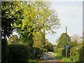
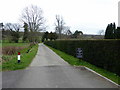
Tye Green Road, Fuller's End, near Elsenham
by Malc McDonald geograph for square TL5325 Tye Green Road in the small hamlet of Fuller's End in north Essex. Signs... (more)
Tags:
AutumnX
Autumn ColoursX
Autumn DayX
Autumn LightX
Autumn TintsX
Autumn TreeX
Autumn Tree ColoursX
Autumnal TreeX
near:Bishops StortfordX
near:ElsenhamX
county:EssexX
Fallen Autumn LeavesX
Fallen LeavesX
type:GeographX
HamletX
subject:HamletX
Minor RoadX
road:Minor RoadX
road sign:No Through Road
No Through Road
No Through Road SignX
No Through Road SignsX
top:Village, Rural SettlementX
|
|
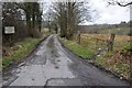
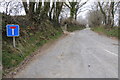
Newmills Hill near Goodrich
by Jaggery geograph for square SO5618 Viewed from the B4229 junction. On the left is a standard No Through Road sign.... (more)
|

|
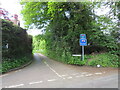
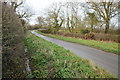
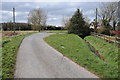
Beggarman's Lane, near Puckeridge
by Malc McDonald geograph for square TL3622 Beggarman's Lane is a minor lane through Hertfordshire countryside. The... (more)
Tags:
Country LaneX
type:GeographX
county:HertfordshireX
subject:LaneX
Minor LaneX
road:Minor RoadX
Minor Rural LaneX
Minor Rural RoadX
No Through Road
road sign:No Through Road
No Through Road SignX
sign:Public FootpathX
Public Footpath SignX
Public Footpath SignpostX
near:PuckeridgeX
top:Roads, Road TransportX
Rural LaneX
Rural RoadX
near:StevenageX
|
|
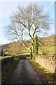
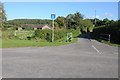
Boast Lane, Barcombe Cross, near Lewes
by Malc McDonald geograph for square TQ4216 Boast Lane is a minor road in East Sussex countryside, near the village of... (more)
Tags:
near:Barcombe CrossX
county:East SussexX
type:GeographX
subject:LaneX
near:LewesX
Minor Country LaneX
Minor LaneX
Minor Rural LaneX
No Through Road
road sign:No Through Road
No Through Road SignX
No Through RouteX
top:Roads, Road TransportX
Rural LaneX
near:UckfieldX
|
|
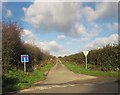
Fen Lane, near Orsett
by Malc McDonald geograph for square TQ6382 This branch of Fen Lane is a no-through-road, as inidcted by the blue sign.
Tags:
county:EssexX
type:GeographX
near:GraysX
subject:LaneX
Narrow Country LaneX
No Through Road
No Through Road for VehiclesX
No Through Road SignX
No Through RouteX
near:OrsettX
top:Roads, Road TransportX
Rural LaneX
near:TilburyX
|
|
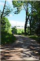
No Through Road at Bateman's
by PAUL FARMER geograph for square TQ6723 The Road leads to Bateman's Mill and is a footpath
|
|
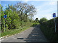
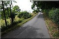
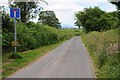
Woolmer Lane, Bramshott, near Liphook
by Malc McDonald geograph for square SU8433 Woolmer Lane is a narrow lane in the village of Bramshott, near Liphook in... (more)
Tags:
place:BramshottX
type:GeographX
county:HampshireX
near:HaslemereX
subject:LaneX
near:LiphookX
Minor Country LaneX
Minor LaneX
Minor Rural LaneX
No Through Road
road sign:No Through Road
No Through Road SignX
top:Roads, Road TransportX
Unsuitable for Heavy Goods VehiclesX
road sign:Unsuitable for Heavy Goods VehiclesX
Unsuitable for Heavy Goods Vehicles SignX
Unsuitable for HGVsX
Unsuitable for HGVs SignX
|
|
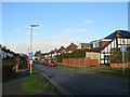
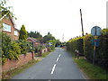
Derek Avenue, West Ewell
by Malc McDonald geograph for square TQ1963 Derek Avenue is a residential road in West Ewell, in Surrey. Signs indicate... (more)
Tags:
near:ChessingtonX
type:GeographX
Long ShadowsX
No Through Road
road sign:No Through Road
No Through Road SignX
ResidentialX
Residential AreaX
Residential RoadX
Residential StreetX
place:South West LondonX
subject:SuburbX
top:Suburb, Urban FringeX
Suburban HousesX
Suburban HousingX
Sunlight and ShadowsX
county:SurreyX
place:West EwellX
Winter ShadowsX
|
|
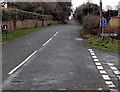
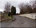
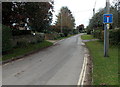
No Through Road from Roborough Road, Barnstaple
by PAUL FARMER geograph for square SS5634 Tags:
place:BarnstapleX
Country RoadX
Country Road JunctionX
type:GeographX
Narrow Country RoadX
road sign:No Through Road
No Through Road
No Through Road SignX
top:PathsX
RoadX
subject:RoadX
top:Roads, Road TransportX
top:Village, Rural SettlementX
|
|
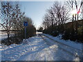
Foxcovert Road, Peakirk, in the snow
by Paul Bryan geograph for square TF1605 Foxcovert Road (occasionally also written in some sources as Fox Covert Road)... (more)
Tags:
top:Air, Sky, WeatherX
Country RoadX
Cul De Sac RoadX
top:Flat LandscapesX
type:GeographX
No Through Road
No Through Road for VehiclesX
No Through Road SignX
No Through RouteX
RoadX
subject:RoadX
top:Roads, Road TransportX
Rural RoadX
Skid Risk SignX
weather:SnowX
SnowX
WinterX
season:WinterX
Winter SceneX
|
|
Signs at the eastern end of Llwyncrwn Road, Beddau
by Jaggery geograph for square ST0684 No motor vehicles except for access and No Through Road. Llwyncrwn Road is not... (more)
|
|
No through road at Talbot's End
by Philip Halling geograph for square ST7090 No through road leading off Farleigh Lane at Cromhall. Beyond the no through... (more)
|
|
Gutteridge Hall Lane, Weeley
by Malc McDonald geograph for square TM1421 The blue square sign indicates that Gutteridge Hall Lane is a no-through road.
Tags:
Cul De Sac RoadX
Cul-De-SacX
county:EssexX
LaneX
subject:LaneX
No Through Road
No Through Road SignX
No Through RouteX
top:Roads, Road TransportX
place:WeeleyX
|
|
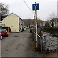
No through road, Penrhiwgarreg, Abertillery
by Jaggery geograph for square SO2203 Signs on the wall show 9-12 Penrhiwgarreg and No Through Road.
At about 280... (more)
Tags:
No Through Road
No Through Road SignX
top:Roads, Road TransportX
top:Suburb, Urban FringeX
top:UplandsX
|
|
No longer a through road
by Mr Ignavy geograph for square SU6254 Category: No Through Road With the new housing development and the new Everest School in Popley this lane... (more)
|
|
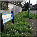
Kinson: Markham Close
by Chris Downer geograph for square SZ0797 In a town that has seen much infill development in the last 20 years, Markham... (more)
Tags:
type:GeographX
top:Housing, DwellingsX
No Through Road
subject:RoadX
RoadX
Road SignX
top:Roads, Road TransportX
SuburbX
top:Suburb, Urban FringeX
|
|
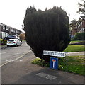
Ensbury Park: Greaves Close
by Chris Downer geograph for square SZ0795 A cul-de-sac off Stanton Road, itself a no-through road, containing these... (more)
Tags:
Detached HousesX
type:GeographX
HousesX
top:Housing, DwellingsX
No Through Road
subject:RoadX
RoadX
Road SignX
top:Roads, Road TransportX
Semi-Detached HousesX
SuburbX
top:Suburb, Urban FringeX
|
|
No through road to Oakwood Farm
by Philip Halling geograph for square SO3159 This no through road provides access to Oakwood Farm at Eywood. This road... (more)
|
|
Rectory Chase, Little Warley
by Malc McDonald geograph for square TQ6089 Rectory Chase is a lane in Little Warley, in Essex. Signs show that Rectory... (more)
Tags:
near:BrentwoodX
county:EssexX
type:GeographX
subject:LaneX
place:Little WarleyX
Narrow Country LaneX
Narrow LaneX
No Through Road
No Through Road SignX
No Through RouteX
top:Roads, Road TransportX
|
|
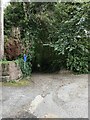
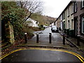
No through road sign, Tramroadside, Newbridge
by Jaggery geograph for square ST2096 Metal barriers across Tramroadside out of shot ahead make this a dead end route... (more)
|
|
Dairyhouse Lane, Bradfield Heath
by Malc McDonald geograph for square TM1429 The square blue sign indicates that Dairyhouse Lane is a no through road.
|
|
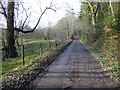
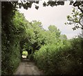
Lane from Newtown
by Derek Harper geograph for square ST9918 The no through lane, actually a continuation of Longcroft Road through Chase... (more)
|
|
Five metal posts across Ynysangharad Road, Pontypridd
by Jaggery geograph for square ST0790 No through road for motor vehicles, but no barrier for walkers and cyclists.... (more)
|
|
Towards the SW end of Coychurch Road, Pencoed
by Jaggery geograph for square SS9580 There are No Through Road signs at this junction with Pencoed Way. Formerly a... (more)
|
|
No through road to The Barnards
by Philip Halling geograph for square SO7930 No through road to The Barnards, though the OS map indicates there is a public... (more)
|
|
No through road
by Philip Halling geograph for square SO6059 No through road providing access to farm buildings and farmland near Hatfield.
|
|
No through road, Dunsmore Green
by Philip Halling geograph for square SO8532 A no through road at Dunsmore Green, Forthampton.
|
|
No Through Road sign, Burleigh
by Jaggery geograph for square SO8601 A dead-end side road diverges from the main road, Brimscombe Hill.
|
|
West along Folly Lane East, Lacock
by Jaggery geograph for square ST9168 The sign shows that this is not a through route. Folly Lane used to be.
Now... (more)
|

|
No through road at Kyrewood
by Philip Halling geograph for square SO6067 No through road off the B4204 at Kyrewood.
|
|
No through road
by Philip Halling geograph for square SO6265 No through road to Honeycombe Farm near Kyre.
|
|
Western end of Water Street, Pontarddulais
by Jaggery geograph for square SN5903 The sign shows No Through Road. In the lower right corner, a bridge... (more)
|
|
No through road except for bicycles, Star Street, Cwmbran
by Jaggery geograph for square ST2994 Near the corner of Broadweir Road. A footpath and cycleway are ahead, at the... (more)
|
|
No through road, Viverdon Down
by Derek Harper geograph for square SX3766 Used by bridleway 631 3/1, which comes to an abrupt halt when the lane meets the... (more)
|
|
No through road to Wernfach
by Philip Halling geograph for square SO2137 No through road to Wernfach, a farm of which some of the buildings are visible.
|
|
No through road
by Philip Halling geograph for square SO1943 No through road near Llowes Common. The Brecon Beacons are in the distance.
|
|
No through road near Manor Farm
by Philip Halling geograph for square SU0799 A no through road approaching Manor Farm to the south of Driffield.
|
|
No through road
by Philip Halling geograph for square SO0066 No through road to Betting to the south of Gaufron.
|
|
No through road
by Philip Halling geograph for square SP1719 No through road to the south of Bourton-on-the-Water.
|
|
No through road
by Philip Halling geograph for square SO2520 No through road near Dryfryn in the shadows of Sugar Loaf.
|
|
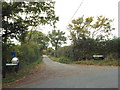
No through road near Clipston
by Philip Halling geograph for square SP7180 This became a no through road when the A14 was built.
|
|
No through road at Gwastad
by Philip Halling geograph for square SN0424 This no through road at Gwastad gives access to Brynteg.
Tags:
No Through Road
top:Roads, Road TransportX
|
|
No through road at Maund Bryan
by Philip Halling geograph for square SO5550 No through road and common land at Maund Bryan.
|
|
No through road
by Philip Halling geograph for square ST6596 No through road to Upper Hill Farm near Hill in the Vale of Berkeley.
|
|
No through road in the Vale of Ewyas
by Philip Halling geograph for square SO2827 This no-through road in the Vale of Ewyas provides access to farms and farmland... (more)
|
|
No Through Road
by Philip Halling geograph for square SO4602 No Through Road to some houses on Star Hill.
|
|
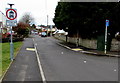
Percy Road, North Finchley
by Malc McDonald geograph for square TQ2692 Percy Road is a residential road in North Finchley, in the suburbs of north... (more)
Tags:
near:BarnetX
Cul-De-SacX
near:FinchleyX
type:GeographX
No Through Road
road sign:No Through Road
No Through Road SignX
place:North FinchleyX
place:North LondonX
ResidentialX
Residential AreaX
Residential RoadX
Residential StreetX
subject:SuburbX
top:Suburb, Urban FringeX
|

|
Crossroads on Henstill Lane
by Hugh Craddock geograph for square SS8103 Crossroads at junction of Henstill Lane with another minor road from... (more)
Tags:
type:GeographX
Give Way Road MarkingsX
Minor Road JunctionX
No Through Road
road sign:No Through Road
subject:Road JunctionX
top:Roads, Road TransportX
|