Public Tags
Tag: Other·Route·with·Public·Access
Other tags: category:Other Route with Public Access
Showing latest 50 of 818 images tagged with Other Route with Public Access tag.
|
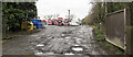
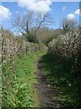
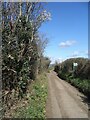
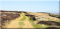
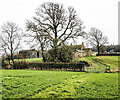
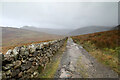
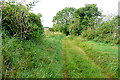
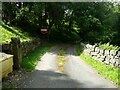
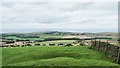
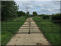
'Other route with public access' passing through haulage yard
by Trevor Littlewood geograph for square NZ0916 Routes with 'other public access' have a curious status. It seems that... (more)
Tags:
top:Boundary, BarrierX
top:Business, Retail, ServicesX
type:GeographX
Haulage YardX
top:LowlandsX
Other Route with Public Access
top:PathsX
Power-Operated GatesX
top:Roads, Road TransportX
|
|
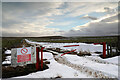
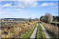
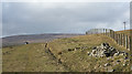
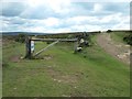
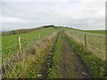
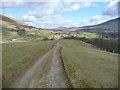
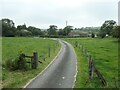
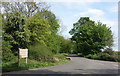
Right of Way into Feldom Range
by Andy Waddington geograph for square NZ0806 Category: Other route with public access Behind the photographer, a bridleway leads to this point. Off to left, and... (more)
|
|
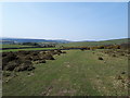
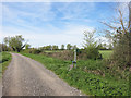
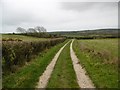
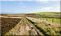
Public access route near Hatchwell Farm
by Vieve Forward geograph for square SX7077 This is not a public footpath, but a public access route linking Widecombe and... (more)
|
|
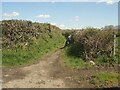
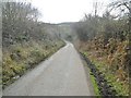
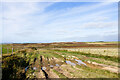
The start of a route with public access just east of Laleston
by eswales geograph for square SS8780 An Ordnance Survey map marked other route with public access seen at its... (more)
Tags:
Ancient Cart TrackX
type:GeographX
area:LalestonX
Other Route with Public Access
top:PathsX
Route with Public AccessX
|
|
Route with public access west of Bryntirion, Bridgend
by eswales geograph for square SS8880 The image shows part of the route of an ancient cart track, marked as an other... (more)
|
|
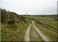
Fremington to Hurst track
by Andy Waddington geograph for square NZ0401 Category: Other route with public access This is one of those tracks whose status is not entirely clear on the OS maps,... (more)
Tags:
type:GeographX
top:MoorlandX
category:Other Route with Public AccessX
top:Roads, Road TransportX
top:UplandsX
|
|
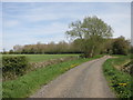
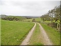
Public access route to minor road near Blackaton
by Vieve Forward geograph for square SX6977 This is not a public footpath, but a public access route linking Widecombe and... (more)
|
|
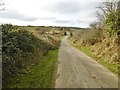
Route with public access just east of Waun Bant Road
by eswales geograph for square SS8482 Mountain Lane seen heading towards Cefn Cribwr just after its start, a spot by... (more)
Tags:
Country TrackX
type:GeographX
Other Route with Public Access
top:PathsX
Route with Public AccessX
subject:TrackX
|
|
Other route with public access at Kenfig
by eswales geograph for square SS8081 This lane has the status of an other route with public access in Ordnance... (more)
Tags:
Footpath SignX
type:GeographX
subject:LaneX
Other Route with Public Access
top:PathsX
top:Roads, Road TransportX
|
|
'Other route with public access' below Scarney Hill
by Trevor Littlewood geograph for square NY9721 The moorland feature, Scarney Hill, rises to the left out of the image. The road... (more)
Tags:
top:Boundary, BarrierX
Dry Stone WallX
type:GeographX
Hill RoadX
Other Route with Public Access
subject:RoadX
top:Roads, Road TransportX
|
|
Other route with public access
by Graham Horn geograph for square SU5959 Presumably its status as a "white" road has diminished over the years.... (more)
|
|
'Public way'
by Trevor Littlewood geograph for square NY7547 The term 'public way' is not seen often; it appears on signposts in... (more)
|
|
Other route with public access below B6277
by Trevor Littlewood geograph for square NY8332 The curious description 'other route with public access' applies to... (more)
|
|
Other Route With Access
by Des Blenkinsopp geograph for square SU3171 An old green lane runs north - south through the middle of SU3171. Designated... (more)
|
|
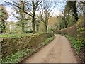
Route with public access near Ingerthorpe Hall
by Derek Harper geograph for square SE2966 Curving along a driveway past Ingerthorpe Cottages. Here the route with public... (more)
Tags:
HedgeX
top:LowlandsX
Other Route with Public Access
top:PathsX
long distance path:Ripon Rowel WalkX
Route with Public AccessX
TreesX
WallX
|
|
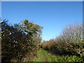
Draycott Road
by Vieve Forward geograph for square SU4098 Draycott Road formerly took vehicular traffic from Southmoor to Draycott Moor... (more)
|
|
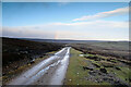
Sandy-surfaced hill road
by Trevor Littlewood geograph for square SE5593 The road, running at the boundary between access land and non-access land... (more)
|
|
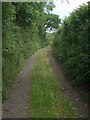
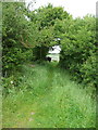
Farthing Lane, Lyneham
by Vieve Forward geograph for square SU0279 An "other route with public access".
|
|
Clough Hey Gate
by Christine Johnstone geograph for square SE0039 Two public footpaths this side of the gate, 'other route with public... (more)
|
|
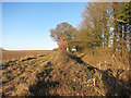
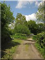
Lane junction, Millhayes
by Derek Harper geograph for square ST2303 There's a maze of little lanes around here; these are two back lanes (both... (more)
|
|
Trace of route across field
by Trevor Littlewood geograph for square NZ0917 The route is an 'ORPA', an 'other route with public access'.... (more)
|
|
Junction of biridleway and Glaisdale Rigg
by Christine Johnstone geograph for square NZ7604 The Rigg is a roughly surfaced 'other route with public access'. The... (more)
Tags:
Dismantled Railway LineX
Disused Mineral LineX
Former Mineral TramwayX
type:GeographX
place:Glaisdale RiggX
national park:North York MoorsX
Old Mineral LineX
Open Access LandX
Open Access MoorlandX
Other Route with Public Access
top:PathsX
Public BridlewayX
top:Roads, Road TransportX
Track and Bridleway JunctionX
subject:Track JunctionX
|
|
Corfe Castle, other route
by Mike Faherty geograph for square SY9782 Other route with public access, descending Rollington Hill towards Sandy Hill Lane.
Tags:
top:Farm, Fishery, Market GardeningX
type:GeographX
subject:HillX
top:LowlandsX
Other Route with Public Access
top:Roads, Road TransportX
subject:RouteX
|
|
Grange, other route
by Mike Faherty geograph for square SY9181 "Other route with public access" from SY9081 : Grange, red flag, along the ridge... (more)
Tags:
top:Farm, Fishery, Market GardeningX
type:GeographX
top:LowlandsX
Other Route with Public Access
top:Roads, Road TransportX
subject:RouteX
|
|
Grange, other route
by Mike Faherty geograph for square SY9081 "Other route with public access", from SY9081 : Grange, red flag along the ridge... (more)
Tags:
top:Farm, Fishery, Market GardeningX
type:GeographX
top:LowlandsX
Other Route with Public Access
top:Roads, Road TransportX
subject:RouteX
|
|
Footpath along Marsh Lane
by Des Blenkinsopp geograph for square SP3000 South of Bampton and Clanfield there is a whole network of wide tracks and lanes... (more)
|
|
Marsh Lane
by Des Blenkinsopp geograph for square SP2901 South of Bampton and Clanfield there is a whole network of wide tracks and lanes... (more)
|
|
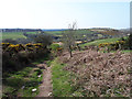
Road heading towards Broomielaw Plantation
by Trevor Littlewood geograph for square NZ0818 The road is at the buildings of Broomielaw and passing a property named The Old... (more)
|
|
Track to Brithdir
by Andy Waddington geograph for square SH5758 Category: Track The bridleway from Snowdon Ranger station over Bwlch Maesgwm has by this point... (more)
Tags:
type:GeographX
top:MoorlandX
category:Other Route with Public AccessX
top:Roads, Road TransportX
top:Sport, LeisureX
category:TrackX
top:UplandsX
|
|
Corfe Castle, other route
by Mike Faherty geograph for square SY9781 Other route with public access, at the base of Rollington Hill, approaching... (more)
Tags:
Farm RoadX
top:Farm, Fishery, Market GardeningX
type:GeographX
top:LowlandsX
Other Route with Public Access
subject:RoadX
top:Roads, Road TransportX
|
|
Corfe Castle, other route
by Mike Faherty geograph for square SY9782 Other route with public access, descending Rollington Hill to Studland Road.
|
|
Rough road rising towards Raisby Quarries
by Trevor Littlewood geograph for square NZ3435 There now seems to be a single massive excavation at Raisby quarries - perhaps... (more)
Tags:
top:Boundary, BarrierX
top:Derelict, DisusedX
type:GeographX
Old Quarry RoadX
Other Route with Public Access
Post and Wire FencingX
top:Quarrying, MiningX
subject:RoadX
|
|
Corfe Common, other route
by Mike Faherty geograph for square SY9580 Other route with public access, across National Trust's Corfe Common from... (more)
Tags:
top:Farm, Fishery, Market GardeningX
type:GeographX
top:LowlandsX
National Trust LandX
Other Route with Public Access
subject:RoadX
top:Roads, Road TransportX
|
|
Corfe Common, other route
by Mike Faherty geograph for square SY9581 Other route with public access, across the National Trust's Corfe Common... (more)
Tags:
top:Farm, Fishery, Market GardeningX
type:GeographX
top:LowlandsX
National Trust LandX
Other Route with Public Access
subject:RoadX
top:Roads, Road TransportX
|
|
The path from Latrigg to Brundholme
by Christine Johnstone geograph for square NY2925 An 'other route with public access' crossing open access land.
Tags:
FellX
type:GeographX
national park:Lake DistrictX
Open Access LandX
Other Route with Public Access
Ridge PathX
top:Roads, Road TransportX
subject:TrackX
|
|
Field access track at the end of Long Rigg
by Humphrey Bolton geograph for square NZ9107 A footpath ('other route with public access') goes through the gate... (more)
|
|
Route to Salperton
by Graham Horn geograph for square SP0921 Leaving the A436 we pass the long barrow on the left hand side then head along... (more)
Tags:
Other Route with Public Access
top:PathsX
|
|
Riding Lane
by Graham Horn geograph for square SU9191 One of those white roads on the map, that is not quite a surfaced route and is... (more)
|
|
Bollards block the Road
by Des Blenkinsopp geograph for square SU1176 What looks like a very old alignment of the main road past Broad Hinton village.... (more)
|
|
Route with public access towards Waun Bant Road
by eswales geograph for square SS8482 Mountain Lane seen about 200 metres from its south western end, a spot on Waun... (more)
Tags:
Country TrackX
type:GeographX
Other Route with Public Access
top:PathsX
Route with Public AccessX
subject:TrackX
|
|
Lane to Egerton, Scammonden
by Humphrey Bolton geograph for square SE0616 For some reason this is an 'other route with public access' rather... (more)
Tags:
type:GeographX
subject:LaneX
top:LowlandsX
Other Route with Public Access
top:Roads, Road TransportX
top:Woodland, ForestX
|
![SK3607 : Approaching Hill's Bridge [no 54] from the south by Christine Johnstone](https://s2.geograph.org.uk/geophotos/06/67/10/6671014_18908fe1_120x120.jpg)
|
Approaching Hill's Bridge [no 54] from the south
by Christine Johnstone geograph for square SK3607 The bridge carries an 'other route with public access' over the Ashby... (more)
Tags:
bridge:Field Access Track Over CanalX
type:GeographX
Other Route with Public Access
top:PathsX
|
|
The road to Ladymeadows Farm
by Christine Johnstone geograph for square SK0253 An 'other route with public access' with an ungated level crossing... (more)
|
|
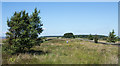
Moorland beside rough road
by Trevor Littlewood geograph for square NZ0746 The heather and grass moorland is part of an area around Whitehall Moss and... (more)
Tags:
type:GeographX
Heather and Grass MoorlandX
top:MoorlandX
subject:MoorlandX
Other Route with Public Access
top:Roads, Road TransportX
top:UplandsX
|
|
Rutted motor route north of Oxen Fell
by Trevor Littlewood geograph for square NZ0745 The route runs north from the buildings at the crossroads at Oxen Fell soon... (more)
Tags:
type:GeographX
top:MoorlandX
MoorlandX
Other Route with Public Access
subject:RoadX
top:Roads, Road TransportX
Rutted RoadX
top:UplandsX
|
|
Descending towards Newton Bank
by Trevor Littlewood geograph for square NZ7814 Although there's no trace of any route on the ground beside the wall... (more)
|
|
Road to Soho Farmhouse
by Des Blenkinsopp geograph for square SP3826 Marked on the map as Green Lane (track) and shown as an other route with public... (more)
|
|
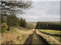
Saltersgate Lane
by Trevor Littlewood geograph for square NZ0742 Saltersgate Lane here is a broad tract of moorland, confined between dry stone... (more)
Tags:
type:GeographX
Grassy MoorlandX
Hill WalkerX
top:MoorlandX
Other Route with Public Access
top:PathsX
top:Sport, LeisureX
top:UplandsX
|
|
Track from Brandon Road
by Hugh Venables geograph for square TL7593 Marked as other route with public access, also along the edge of the open access area.
Tags:
type:GeographX
Other Route with Public Access
top:PathsX
Thetford ForestX
top:Woodland, ForestX
|
|
Gate on Cow Lane
by Hugh Venables geograph for square TL4370 Marked as 'Other route with public access' and a council right of way... (more)
|