|
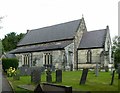
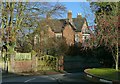
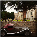
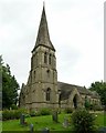
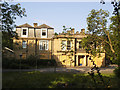
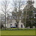
Church of St John the Baptist, Smalley
by Alan Murray-Rust
geograph for square SK4044
1850s porch in neo-Norman style.
|
|
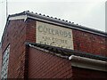
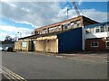
Old sign on the former Collards Butchers
by Sofia
for square ST5871
Collards Butchers opened in the 1850s. It later expanded to shops in Bedminster... (more)
|
|
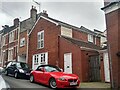
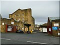
Former Collards Butchers, Braunton Road
by Sofia
geograph for square ST5871
Collards Butchers opened in the 1850s. It later expanded to shops in Bedminster... (more)
|
|
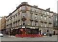
The Griffin, Bath Street at Elmbank Street
by Alan Murray-Rust
geograph for square NS5865
Tenement building of c.1850, with later public house of 1904 in Art Nouveau... (more)
|
|
Park House, Riddings
by Alan Murray-Rust
geograph for square SK4252
Formerly the farmhouse of Riddings Farm. Built c.1850, the decorative brickwork... (more)
|
|
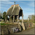
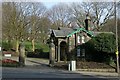
Lych gate, Ashwell churchyard
by Alan Murray-Rust
geograph for square SK8613
The wall around the churchyard, including this lych gate in the eastern section,... (more)
|
|
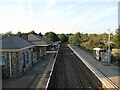
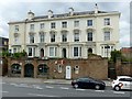
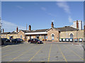
Chepstow Railway Station
by Sofia
geograph for square ST5393
Chepstow Railway Station was built in 1850. The buildings on the Chepstow side... (more)
|
|
Entrance to Waterloo Promenade, Forest Road West, Nottingham gate pier
by Alan Murray-Rust
geograph for square SK5640
Waterloo Promenade was developed in the 1850s as part of improvements under the... (more)
|
|
Entrance to Waterloo Promenade, Forest Road West, Nottingham
by Alan Murray-Rust
geograph for square SK5640
Waterloo Promenade was developed in the 1850s as part of improvements under the... (more)
|
|
Railings and wall at Wellington Circus, Nottingham
by Alan Murray-Rust
geograph for square SK5639
Dating from the original development of the area c.1850, Listed Grade II.
|
|
4 8 Oxford Street, Nottingham
by Alan Murray-Rust
geograph for square SK5639
A terrace of 3 houses from c.1850. Now converted to apartments.
|
|
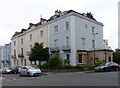
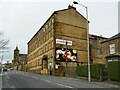
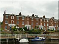
Nelson Parade from Boot Lane
by Sofia
geograph for square ST5871
Nelson Parade was built during the 1850s, and extended in the 1860s. From... (more)
|
|
St Mark's Church
by Sofia
for square ST3847
St Mark's Church was built in April 1268 as The Church of the Holy Cross.... (more)
|
|
Bard House, Shakespeare Street, Nottingham
by Alan Murray-Rust
geograph for square SK5740
Built c.1850 as a large town house, later an adult education centre for the... (more)
|
|
140-150 Hill Street, Garnethill, Glasgow
by Alan Murray-Rust
geograph for square NS5866
Tenement housing, c.1850, formerly part of the larger Randolph Terrace, Listed... (more)
|
|
1 Broadway, Nottingham
by Alan Murray-Rust
geograph for square SK5739
One of T C Hine's group of buildings forming Broadway, built for several... (more)
|
|
1 Kaye's Walk and Eastgate House, Stoney Street
by Alan Murray-Rust
geograph for square SK5739
Lace warehouses. The two premises appear to have been built as a single unit,... (more)
|
|
Parson's Cottage, Ironville
by Alan Murray-Rust
geograph for square SK4351
Formerly The Poplars, built c.1850 in Tudor Revival style, Listed Grade II.... (more)
|
|
Brunel Terrace, Derby Road
by Alan Murray-Rust
geograph for square SK5640
A group of 5 town houses from c.1850, later the Regency Hotel, now converted to... (more)
|
|
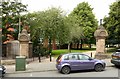
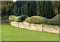
Walls near the Golden Gates
by Alan Murray-Rust
geograph for square SK4032
Erected around 1850 as part of the landscaping of the park by William Barron.... (more)
|
|
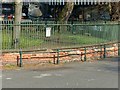
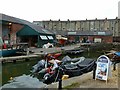
Underfall Yard slipway
by Alan Murray-Rust
geograph for square ST5772
To the right can be seen the cross-members of the cradle of the slipway. This... (more)
|
|
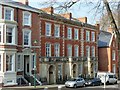
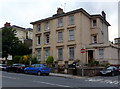
9 & 11 Richmond Park Road
by Alan Murray-Rust
geograph for square ST5773
Pair of attached houses, c.1850, limestone ashlar in neoclassical style, Listed... (more)
|
|
Clifton Park houses
by Alan Murray-Rust
geograph for square ST5773
A group of three attached houses on the corner of Clifton Park and Christchurch... (more)
|
|
Dyrham Court, Clifton Park
by Alan Murray-Rust
geograph for square ST5773
One of a small number of detached houses in the immediate neighbourhood.... (more)
|
|
44 & 46 Pembroke Road
by Alan Murray-Rust
geograph for square ST5773
Pair of attached houses, painted limestone ashlar, c.1850, Listed Grade II
|
|
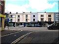
Southleigh Road, west side, 16-38
by Alan Murray-Rust
geograph for square ST5773
Terraced houses, c.1850 in neo-classical style, with some variation of... (more)
|
|
Entrance to the Lido
by Alan Murray-Rust
for square ST5773
Built in around 1850 as a swimming pool with ancillary baths, etc. Refurbished... (more)
|
|
46 & 438 St Paul's Road, Clifton
by Alan Murray-Rust
geograph for square ST5773
A pair of neo-classical attached houses, c.1850. Listed Grade II.
|
|
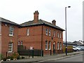
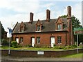
8 Station Road, Grantham
by Alan Murray-Rust
geograph for square SK9135
House built c.1850 by the Great Northern Railway possibly for the Station... (more)
|
|
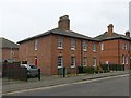
6-7 Station Road, Grantham
by Alan Murray-Rust
geograph for square SK9135
Pair of cottages built c.1850 by the Great Northern Railway for its employees.... (more)
|
|
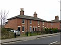
25 Station Road, Grantham
by Alan Murray-Rust
geograph for square SK9135
Group of 4 cottages built c.1850 by the Great Northern Railway for its... (more)
|
|
St Mary's Church, Abberley
by Alan Murray-Rust
geograph for square SO7567
Built 1850-2 by J J Cole as a replacement for the ruinous St Michael's... (more)
|
|
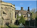
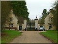
Gateway to Exton Hall
by Alan Murray-Rust
geograph for square SK9111
A pair of lodges flanking a gateway with ornamental wrought iron gates and stags... (more)
|
|
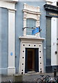
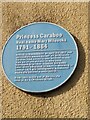
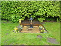
Blue plaque commemorating Princess Caraboo
by Sofia
for square ST5971
This blue plaque on the old Parker Bros. Tannery commemorates Princess Caraboo,... (more)
|
|
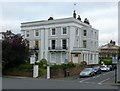
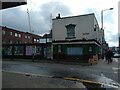
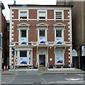
The Barley Mow, East Street
by Sofia
geograph for square ST5871
The Barley Mow was built around 1850 over a former stream. In 1853, the licensee... (more)
|
|
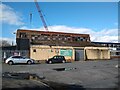
Eastman & Co Timber Ltd.
by Sofia
geograph for square ST5971
Eastman & Co Timber Ltd. is on the site of a Parker Bros. Tannery which is... (more)
|
|
Eastman & Co Timber Ltd.
by Sofia
geograph for square ST5971
Eastman & Co Timber Ltd. is on the site of a Parker Bros. Tannery which is... (more)
|
|
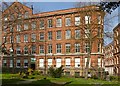
Allerton Mill (2)
by Stephen Craven
geograph for square SE1234
Once an extensive worsted mill, built c.1850-60, like most such former mill... (more)
|
|
Allerton Mill
by Stephen Craven
geograph for square SE1234
Once an extensive worsted mill, built c.1850-60, and at the time that the two... (more)
|
|
37 Tanner Row
by Bob Harvey
geograph for square SE5951
Built around 1850 as the George Hotel, serving the first of York's railway... (more)
|
|
Deva Terrace
by Stephen Craven
geograph for square SJ4166
This 1850s terrace overlooking the Dee is listed grade II, entry 1375769.
|
|
2-6 Manor Road, King's Bromley
by Alan Murray-Rust
geograph for square SK1216
A group of three almshouses, c.1850, built by the Lane family... (more)
|
|
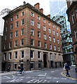
Grade II listed building
by Bob Harvey
geograph for square SJ8398
Described as "31 Pall Mall, 1 Booth Street" by Historic England, the... (more)
|
|
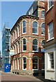
12 Shakespeare Street, Nottingham
by Alan Murray-Rust
geograph for square SK5740
Town house of c.1850, converted to offices late 20th century, Listed Grade II.
|
|
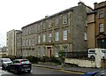
Bolton Royd, Manningham Lane
by Stephen Craven
geograph for square SE1534
Built c.1850-55, as a private villa, and latterly used as a college building... (more)
|
|
Towie parish hall
by Bill Harrison
geograph for square NJ4412
Dating from ca. 1850 and possibly a former Oddfellows' hall:... (more)
|
|
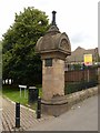
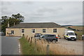
Village water stanchion
by Bob Harvey
geograph for square TF0226
|
|
Lodge to Bankfield
by Alan Murray-Rust
geograph for square SE0926
Built at the time that Edward Akroyd was enlarging the house at Bankfield... (more)
|
|
The Old Manse, Cluny
by Bill Harrison
geograph for square NJ6812
C-listed (see:... (more)
|
|
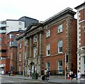
Newark Northgate Station
by Alan Murray-Rust
geograph for square SK8054
Although there are modern accretions, the original building from around 1850... (more)
|