Public Tags
Showing latest 50 of 96 images tagged with place:Aldford tag.
|
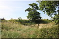
Aldford Castle (Blobb Hill) Motte
by Jeff Buck geograph for square SJ4159 The motte of Aldford Castle (also known as Blobb Hill). Aldford Castle is... (more)
Tags:
place:Aldford
Aldford CastleX
county:CheshireX
country:EnglandX
type:GeographX
top:Historic Sites and ArtefactsX
MotteX
Motte and BaileyX
Motte and Bailey CastleX
Norman MotteX
top:Village, Rural SettlementX
|
|
Motte and Bailey earthworks at Aldford Castle
by Jeff Buck geograph for square SJ4159 Aldford Castle is situated to the north of the church. It was founded by Richard... (more)
Tags:
place:Aldford
CastleX
place:CheshireX
EarthworksX
top:Historic Sites and ArtefactsX
Motte and BaileyX
top:Village, Rural SettlementX
|
|
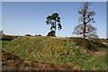
Aldford Motte and Bailey Castle (Blobb Hill)
by Jeff Buck geograph for square SJ4159 Aldford Castle is situated to the north of the church. It was founded by Richard... (more)
Tags:
place:Aldford
CastleX
place:CheshireX
top:Historic Sites and ArtefactsX
Motte and BaileyX
VillageX
top:Village, Rural SettlementX
|
|
|
Aldford Castle (Blobb Hill)
by Jeff Buck geograph for square SJ4159 Aldford Castle is situated to the north of Aldford church. It was founded by... (more)
Tags:
place:Aldford
CastleX
county:CheshireX
country:EnglandX
type:GeographX
top:Historic Sites and ArtefactsX
Motte and BaileyX
Motte and Bailey CastleX
top:Village, Rural SettlementX
|
|
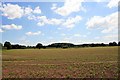
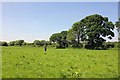
View towards Aldford
by Jeff Buck geograph for square SJ4059 The view east across the fields towards Aldford as seen from the path alongside... (more)
|
|
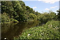
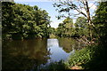
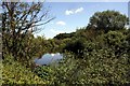
The River Dee near Aldford
by Jeff Buck geograph for square SJ4159 A calm looking River Dee as it slowly flows to the west of Aldford. Taken during... (more)
|
|
Riverside footpath near Aldford
by Jeff Buck geograph for square SJ4159 A riverside walk to the west of Aldford along the River Dee (the river is on the... (more)
|
|
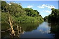
The River Dee near Aldford
by Jeff Buck geograph for square SJ4159 A calm looking River Dee as it slowly flows to the west of Aldford. Taken during... (more)
|
|
The River Dee at Aldford
by Jeff Buck geograph for square SJ4159 A calm looking River Dee as it slowly flows to the west of Aldford. Taken during... (more)
|
|
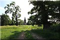
Approaching Aldford
by Jeff Buck geograph for square SJ4159 Approaching the village of Aldford from the north through the earthworks of... (more)
Tags:
place:Aldford
Castle (Remains)X
site of:Castle RemainsX
Castle RemainsX
county:CheshireX
EarthworksX
country:EnglandX
type:GeographX
top:Historic Sites and ArtefactsX
top:PathsX
top:Village, Rural SettlementX
|
|
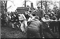
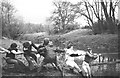
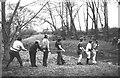
Aldford Tug of War, May Day 1979
by Jeff Buck for square SJ4259 The Aldford tug of war competition over Aldford Brook on May Day Bank Holiday... (more)
Tags:
place:Aldford
BrookX
county:CheshireX
type:Close LookX
country:EnglandX
May DayX
top:People, EventsX
Tug of WarX
top:Village, Rural SettlementX
|
|
Aldford Tug of War, May Day 1979
by Jeff Buck geograph for square SJ4259 Aldford tug of war competition over Aldford Brook on May Day Bank Holiday 1979.... (more)
Tags:
place:Aldford
BrookX
county:CheshireX
country:EnglandX
type:GeographX
May DayX
top:People, EventsX
top:Rivers, Streams, DrainageX
Tug of WarX
top:Village, Rural SettlementX
|
|
Aldford Tug of War, May Day 1979
by Jeff Buck geograph for square SJ4259 A team prepares for the Aldford tug of war competition over Aldford Brook on May... (more)
Tags:
place:Aldford
BrookX
county:CheshireX
country:EnglandX
type:GeographX
May DayX
top:People, EventsX
top:Rivers, Streams, DrainageX
Tug of WarX
top:Village, Rural SettlementX
|
|
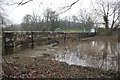
Aldford Brook in flood
by Jeff Buck geograph for square SJ4259 Aldford Brook in flood at Aldford Bridge.
Tags:
place:Aldford
BridgeX
BrookX
Brook in FloodX
county:CheshireX
country:EnglandX
Flooded BrookX
top:Rivers, Streams, DrainageX
|
|
Aldford Brook in flood
by Jeff Buck geograph for square SJ4259 Aldford Brook in flood at Aldford Bridge.
|
|
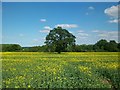
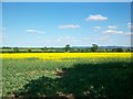
Field of Rapeseed near Aldford
by Jeff Buck geograph for square SJ4258 From Lower Lane between Aldford and Churton.
|
|
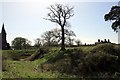
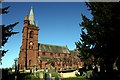
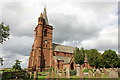
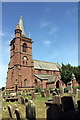
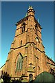
St John the Baptist's Church, Aldford
by Jeff Buck geograph for square SJ4159 The church was built in 1866 on the site of a previous church to a design by... (more)
|
|
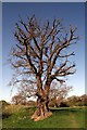
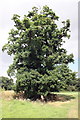
600 Year Old Oak tree near Aldford Castle
by Jeff Buck geograph for square SJ4159 The 600 year old oak tree next to Aldford Castle (Blobb Hill) still awaiting the... (more)
|
|
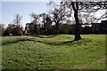
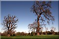
Trees near Aldford Castle
by Jeff Buck geograph for square SJ4159 Trees still awaiting the leaves to appear next to Aldford Castle (Blobb Hill).
|
|
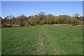
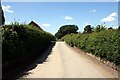
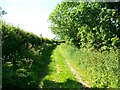
Footpath near Aldford
by Jeff Buck geograph for square SJ4159 Footpath north of Aldford seen here heading towards Iron Bridge over the River Dee.
|
|
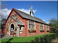
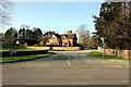
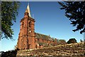
Aldford Village Hall
by Jeff Buck geograph for square SJ4159 Aldford Village Hall on Church Lane.
|
|
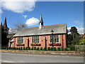
Aldford Village Hall
by Jeff Buck geograph for square SJ4159 Aldford Village Hall on Church Lane. The tower of St John's Church can be... (more)
|
|
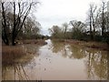
Aldford Brook in Flood
by Jeff Buck geograph for square SJ4259 Aldford Brook looking more like a river after recent heavy rain.
|
|
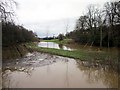
Aldford Brook in Flood
by Jeff Buck geograph for square SJ4259 Looking north along the brook from Aldford Bridge.
|
|
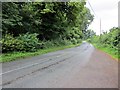
The B5130 near Aldford
by Jeff Buck geograph for square SJ4261 The B5130 near the 'Crook of Dee' looking north as it heads away from Aldford.
|
|
The B5130 near Aldford
by Jeff Buck geograph for square SJ4261 The B5130 near the 'Crook of Dee' looking south as it heads towards Aldford.
|
|
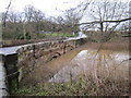
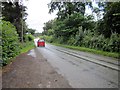
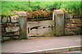
Road Junction in Aldford
by Jeff Buck geograph for square SJ4259 The junction of Church Lane and Chester Road, taken from near Aldford Bridge.
Tags:
place:Aldford
Road and Lane JunctionX
top:Roads, Road TransportX
top:Village, Rural SettlementX
|
|
The River Dee near Aldford
by Jeff Buck geograph for square SJ4158 The River Dee as seen from the riverside path between Aldford and Churton.
|
|
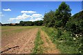
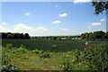
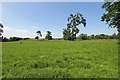
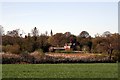
Field near Aldford
by Jeff Buck geograph for square SJ4159 A field to the west of Aldford.
Tags:
place:Aldford
Arable FieldX
top:Farm, Fishery, Market GardeningX
FieldX
top:Village, Rural SettlementX
|
|
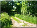
Footpath in Aldford
by Jeff Buck geograph for square SJ4159 Lane heading towards the River Dee at Aldford.
|
|
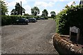
Aldford Village car park
by Jeff Buck geograph for square SJ4159 The village car park on Church Lane in Aldford, useful for exploring the area.
|
|
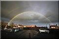
Double Rainbow at Aldford
by Jeff Buck geograph for square SJ4259 A double rainbow seen from the Grosvenor Arms car park at Aldford.
Tags:
top:Air, Sky, WeatherX
place:Aldford
county:CheshireX
Double RainbowX
country:EnglandX
type:GeographX
RainbowX
top:Village, Rural SettlementX
|
|
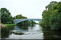
The Iron Bridge at Aldford
by Jeff Buck geograph for square SJ4160 The Grade I listed bridge at Aldford.
Wikipedia... (more)
Tags:
place:Aldford
BridgeX
county:CheshireX
country:EnglandX
type:GeographX
top:Historic Sites and ArtefactsX
Iron BridgeX
top:Rivers, Streams, DrainageX
|

|
Boat trip to Aldford Iron Bridge
by Jeff Buck geograph for square SJ4160 Tourists view Aldford Iron Bridge from a boat cruise on the River Dee.... (more)
|
|
Aldford Castle (Blobb Hill) Motte and Bailey
by Jeff Buck for square SJ4159 The site of Aldford Castle (Blobb Hill) seen from across the bailey from the east.
Tags:
place:Aldford
Castle (Remains)X
Castle BaileyX
site of:Castle RemainsX
Castle RemainsX
county:CheshireX
type:Cross GridX
EarthworksX
country:EnglandX
top:Historic Sites and ArtefactsX
Motte and BaileyX
Motte and Bailey CastleX
|
|
A field near Aldford
by Jeff Buck geograph for square SJ4058 Dairy farmland near Aldford and the River Dee.
|
|
St John the Baptist's Church, Aldford
by Jeff Buck geograph for square SJ4159 St John the Baptist's Church in Aldford was built in 1866 and is a Grade II... (more)
Tags:
place:Aldford
county:CheshireX
ChurchX
ChurchyardX
country:EnglandX
type:GeographX
Grade II Listed BuildingX
top:Religious SitesX
top:Village, Rural SettlementX
|
|
Aldford Village Stocks
by Jeff Buck geograph for square SJ4259 Aldford Village Stocks next to the B5130 are made from sandstone and oak and... (more)
Tags:
place:Aldford
road:B5130X
county:CheshireX
country:EnglandX
type:GeographX
Grade II ListedX
Grade II Listed StructureX
top:Historic Sites and ArtefactsX
StocksX
Village StocksX
top:Village, Rural SettlementX
|
|
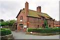
Aldford Post Office and Village Store
by Jeff Buck geograph for square SJ4159 Aldford Post Office and village store on the corner of Middle Lane and Church... (more)
Tags:
place:Aldford
top:Business, Retail, ServicesX
county:CheshireX
country:EnglandX
type:GeographX
Grade II Listed BuildingX
style:JacobeanX
Listed BuildingX
Post OfficeX
Post Office and General StoreX
Village StoreX
Village Store and Post OfficeX
top:Village, Rural SettlementX
|
|
The 600 Year Old Aldford Oak in Summer
by Jeff Buck geograph for square SJ4159 The 600 year old oak tree next to Aldford Castle (Blobb Hill) now with its... (more)
|
|
View of Beeston and Peckforton Hills
by Jeff Buck geograph for square SJ4258 Taken from Lower Lane near Aldford.
|
|
View towards Eaton Hall
by Jeff Buck geograph for square SJ4159 The view of Iron Bridge Lodge and Eaton Hall Tower from the footpath north of Aldford.
|
|
Footpath to Aldford
by Jeff Buck geograph for square SJ4256 The section of path near to Stud Farm.
|
|
Footpath to Aldford
by Jeff Buck geograph for square SJ4256 The start of the footpath from Lower Lane near Churton.
|
|
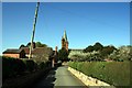
Middle Lane, Aldford
by Jeff Buck geograph for square SJ4159 Middle Lane heading towards St John the Baptist's Church.
|
|
St John the Baptist's Church, Aldford
by Jeff Buck geograph for square SJ4159 The church was built in 1866 on the site of a previous church to a design by... (more)
Tags:
place:Aldford
place:CheshireX
ChurchX
Church TowerX
top:Religious SitesX
VillageX
top:Village, Rural SettlementX
|
|
St John the Baptist's Church, Aldford
by Jeff Buck geograph for square SJ4159 The church was built in 1866 on the site of a previous church to a design by... (more)
|
|
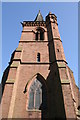
The tower of St John the Baptist's Church, Aldford
by Jeff Buck for square SJ4159 The church was built in 1866 on the site of a previous church to a design by... (more)
Tags:
place:Aldford
place:CheshireX
ChurchX
Church TowerX
top:Religious SitesX
VillageX
top:Village, Rural SettlementX
|